Bank nearby Bank of Ceylon
Sri Lanka
Bank nearby Bank of Ceylon
Bank of Ceylon
"Wijethunga Building", A5, Maha Oya Sri Lanka
contacts phone
:
+94
Latitude:
7.5305119
, Longitude:
81.3562224
read more
nearest Bank
129 m
Regional Development Bank
A5, Maha Oya
Bank
read more
136 m
People's Bank
Maha Oya
Bank
read more
18.698 km
Bimputh Finance PLC
Peradeniya-Badulla-Chenkaladi Highway, Padiyatalawa
Bank
read more
18.713 km
Bank of Ceylon Padiyathalawa Branch, ලංකා බැංකුව පදියතලාව ශාඛාව
Padiyatalawa
Bank
read more
18.728 km
Peoples Bank
Padiyatalawa
Bank
read more
18.892 km
LOLC MICRO CREDIT
Padiyathalawa Hospital Road
Bank
read more
23.115 km
Sanasa Bank
Polonnaruwa
Bank
read more
27.388 km
Bank of Ceylon Karadiyanaru Branch ලංකා බැංකුව කරදියනාරු shaakhaava
Karadiyanaru
Bank
read more
33.779 km
People's Bank
B502, Aralaganwila
Bank
read more
39.121 km
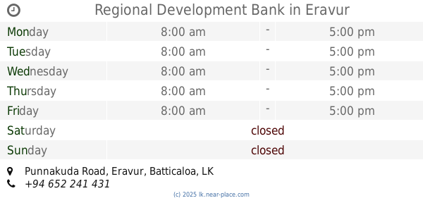
Regional Development Bank
Punnakuda Road, Eravur
Bank
read more
40.171 km
Peoples Bank Kokkaddicholai
Kokkaddicholai, Batticaloa
Bank
read more
42.957 km
Samurdhi Bank Office-Vellavely
Unnamed Road
Bank
read more
43.288 km
Commercial Bank & ATM
No 42, Bar Road, Batticaloa
Bank
read more
43.355 km
Rideemaliyadda Co-Operative Rural Bank
Rideemaliyadda
Bank
read more
44.013 km
National Development Bank PLC
103F, D. S. Senanayke Road, Ampara Town
Bank
read more
44.025 km
CDB Amapara
66 D.S.Senanayake Street, Ampara
Bank
read more
44.486 km
SMIB
Ampara
Bank
read more
44.491 km
State Mortgage and Investment Bank (SMIB)
Ampara
Bank
read more
47.855 km
DFCC Bank PLC
Welikanda
Bank
read more
48.014 km
Bank of Ceylon Malwatta Branch
Ampara
Bank
read more
50.757 km
Irakkamam peoples bank
Sri Lanka, Eragama
Bank
read more
52.505 km
National Savings Bank & ATM ජාතික ඉතිරි කිරීමේ බැංකුව
Sammanthurai
Bank
read more
52.861 km
People's Bank
Karativu-Ampara Highway, Sammanthurai
Bank
read more
55.406 km
Regional Development Bank
Karamettiya Kandakettiya Road, Kandakettiya Town
Bank
read more
55.83 km
People's Bank
Galauda-kandaketiya Road, Kandakettiya Town
Bank
read more
📑
all categories
Accounting
Administrative area level 1
Administrative area level 2
Airport
Amusement park
Aquarium
Art gallery
Atm
Bakery
Bank
Bar
Beauty salon
Bicycle store
Book store
Bowling alley
Bus station
Cafe
Campground
Car dealer
Car rental
Car repair
Car wash
Casino
Cemetery
Church
City hall
Clothing store
Colloquial area
Convenience store
Country
Courthouse
Dentist
Department store
Doctor
Electrician
Electronics store
Embassy
Finance
Fire station
Florist
Food
Funeral home
Furniture store
Gas station
General contractor
Grocery or supermarket
Gym
Hair care
Hardware store
Health
Hindu Temple
Home goods store
Hospital
Insurance agency
Intersection
Jewelry store
Laundry
Lawyer
Library
Light rail station
Liquor store
Local government office
Locality
Locksmith
Lodging
Meal delivery
Meal takeaway
Mosque
Movie rental
Movie theater
Moving company
Museum
Natural feature
Neighborhood
Night club
Painter
Park
Parking
Pet store
Pharmacy
Physiotherapist
Place of worship
Plumber
Point of interest
Police
Political
Post office
Premise
Real estate agency
Restaurant
Roofing contractor
Route
Rv park, camping
School
Shoe store
Shopping mall
Spa
Stadium
Storage
Store
Subpremise
Supermarket
Synagogue
Taxi stand
Train station
Transit station
Travel agency
University
Veterinary care
Zoo
administrative area level 3
sublocality level 1
sublocality level 2
↑