Bank nearby People's Bank
Coronavirus disease (COVID-19) Situation
confirmed cases
672754
deaths
16897
Sri Lanka
Bank nearby People's Bank
People's Bank
B106, Gonapinuwala, Galle, LK Sri Lanka
contacts phone
:
+94 912 277 950
website:
www.peoplesbank.lk
Latitude:
6.1412015
, Longitude:
80.1369596
larger map & directions
read more
nearest Bank
1.051 km
සමෘද්ධි ප්රජාමූල බැංකුව
Dodanduwa - Gonapinuwala Road, Gonapinuwala
Bank
read more
2.355 km
Keradewala Sanasa කෙරදේවල සණස
Galle
Bank
read more
2.488 km
DFCC bank - BADDEGAMA
No 73,Baddegama -Galle Road, Udakubura ,, Baddegama.
Bank
read more
3.431 km
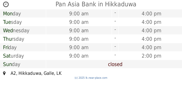
Pan Asia Bank
A2, Hikkaduwa
Bank
read more
3.485 km
Sanasa Society
Dodandugoda Road, Hikkaduwa
Bank
read more
3.573 km
People's Bank
A2, Dodanduwa
Bank
read more
3.718 km
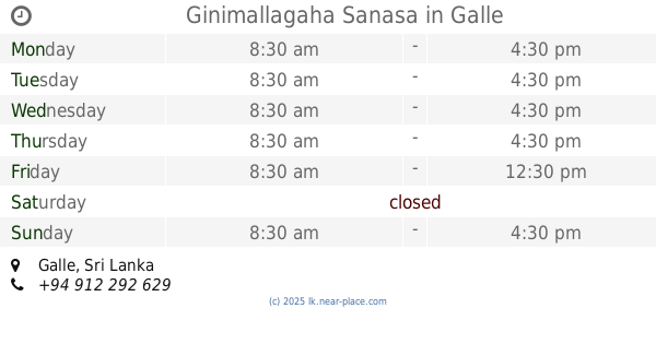
Ginimallagaha Sanasa
Galle
Bank
read more
3.785 km
DFCC BANK
Hikkaduwa
Bank
read more
4.094 km
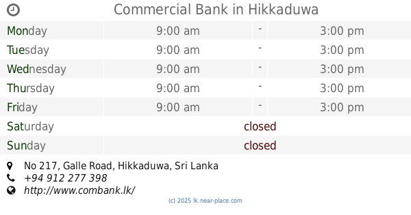
Commercial Bank
Thiranagama
Bank
read more
4.099 km
Commercial Bank
No 217, Galle Road, Hikkaduwa
Bank
read more
4.108 km
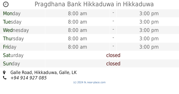
Pragdhana Bank Hikkaduwa
Galle Road, Hikkaduwa
Bank
read more
4.12 km
Nations Trust Bank PLC
290 Galle Road, Hikkaduwa
Bank
read more
4.122 km
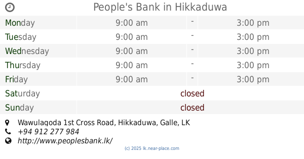
People's Bank
Wawulagoda 1st Cross Road, Hikkaduwa
Bank
read more
4.3 km
Fishery Co op Society
A2, Dodanduwa
Bank
read more
4.359 km
BOC Bank
Aluthwala
Bank
read more
4.411 km
Co-oparative Rural Bank
Dodanduwa
Bank
read more
4.85 km
Nations Trust Bank
08, Galle Road, Hikkaduwa
Bank
read more
5.336 km
Thelikada Sanasa Bank
Telikada
Bank
read more
5.425 km
Pragdhana Bank
gothatuwa junction, Baddegama
Bank
read more
5.485 km
DFCC Bank Unit - Baddegama
Kumme Grounds, B128, Baddegama
Bank
read more
5.565 km
MAX
139, Swarnapura, Wawlagala,, Baddegama, Galle
Bank
read more
5.636 km
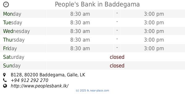
People's Bank
Kumme Grounds, B128, Baddegama
Bank
read more
5.707 km
National Savings Bank
B128, Baddegama
Bank
read more
5.709 km
DFCC Bank
Baddegama
Bank
read more
6.28 km
Horagampita Sanasa
Horagampita
Bank
read more
📑
all categories
Accounting
Administrative area level 1
Administrative area level 2
Airport
Amusement park
Aquarium
Art gallery
Atm
Bakery
Bank
Bar
Beauty salon
Bicycle store
Book store
Bowling alley
Bus station
Cafe
Campground
Car dealer
Car rental
Car repair
Car wash
Casino
Cemetery
Church
City hall
Clothing store
Colloquial area
Convenience store
Country
Courthouse
Dentist
Department store
Doctor
Electrician
Electronics store
Embassy
Finance
Fire station
Florist
Food
Funeral home
Furniture store
Gas station
General contractor
Grocery or supermarket
Gym
Hair care
Hardware store
Health
Hindu Temple
Home goods store
Hospital
Insurance agency
Intersection
Jewelry store
Laundry
Lawyer
Library
Light rail station
Liquor store
Local government office
Locality
Locksmith
Lodging
Meal delivery
Meal takeaway
Mosque
Movie rental
Movie theater
Moving company
Museum
Natural feature
Neighborhood
Night club
Painter
Park
Parking
Pet store
Pharmacy
Physiotherapist
Place of worship
Plumber
Point of interest
Police
Political
Post office
Premise
Real estate agency
Restaurant
Roofing contractor
Route
Rv park, camping
School
Shoe store
Shopping mall
Spa
Stadium
Storage
Store
Subpremise
Supermarket
Synagogue
Taxi stand
Train station
Transit station
Travel agency
University
Veterinary care
Zoo
administrative area level 3
sublocality level 1
sublocality level 2
↑