Bank nearby Peoples Bank, Kotikawatta
Coronavirus disease (COVID-19) Situation
confirmed cases
672754
deaths
16897
Sri Lanka
Bank nearby Peoples Bank, Kotikawatta
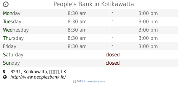
Peoples Bank, Kotikawatta
B435, Kotikawatta, කොළඹ, LK Sri Lanka
contacts phone
:
+94 112 578 253
website:
www.peoplesbank.lk
Latitude:
6.9360388
, Longitude:
79.9167555
larger map & directions
read more
nearest Bank
22 m
Co-Op Bank
Bank
read more
22 m
Co-Op Bank
Sri Lanka
Bank
read more
57 m
SANASA Society
B435
Bank
read more
57 m
The Kotikawatta Thrift & Credit Cooperative Society
Kotikawatta East
Bank
read more
347 m
Commercial Bank
Angoda
Bank
read more
1.394 km
Sampath Bank
No. 55/4 Buthgamuwa Road
Bank
read more
1.447 km
People's Bank
B231, Angoda
Bank
read more
1.463 km
People's Bank
Kotikawatta, B231, Kotikawatta
Bank
read more
1.528 km
Seylan Bank PLC
B231
Bank
read more
1.535 km
Nations Trust Bank
35 B231, Kotikawatta
Bank
read more
1.544 km
Sampath Bank Kelaniya
1017 Biyagama Road, Peliyagoda
Bank
read more
1.548 km
People's Bank Kelaniya
1017 Biyagama Road, Peliyagoda
Bank
read more
1.591 km
Samurdhi Bank - Gothatuwa
Bopetta
Bank
read more
1.609 km
Sanasa Bank
Kotikawatta
Bank
read more
1.611 km
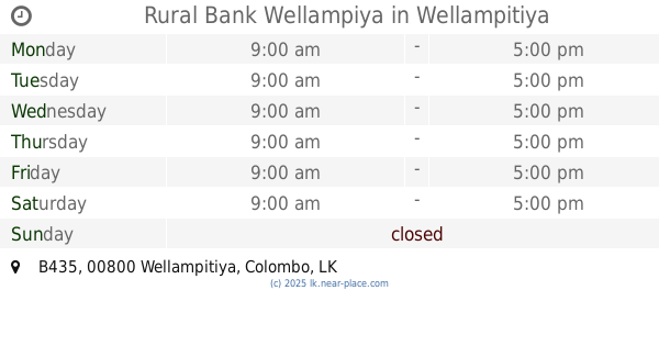
Rural Bank Wellampiya
B435, Wellampitiya
Bank
read more
1.669 km
ග්රමීය බැංකුව - කැලණිය
Kelaniya, Peliyagoda
Bank
read more
1.913 km
Hatton National Bank - HNB Kelaniya
B214, Peliyagoda
Bank
read more
1.913 km
HNB Kelaniya
B214, Peliyagoda
Bank
read more
1.928 km
Hatton National Bank
182 Negombo Road, Peliyagoda
Bank
read more
1.967 km
Business Development Cooperative Society
B435, Angoda
Bank
read more
1.982 km
NSB Bank
879A Waragoda Road, Peliyagoda
Bank
read more
1.982 km
National Savings Bank
879A Waragoda Road, Peliyagoda
Bank
read more
2.568 km
The Co-operative Bank, Polhena, Kelaniya
Polhena Road, Peliyagoda
Bank
read more
2.852 km
HNB Bank
Kolonnawa Road, Sri Jayawardenepura Kotte
Bank
read more
3.729 km
Citizen Development Bank
No. 1424, Cotta Road
Bank
read more
📑
all categories
Accounting
Administrative area level 1
Administrative area level 2
Airport
Amusement park
Aquarium
Art gallery
Atm
Bakery
Bank
Bar
Beauty salon
Bicycle store
Book store
Bowling alley
Bus station
Cafe
Campground
Car dealer
Car rental
Car repair
Car wash
Casino
Cemetery
Church
City hall
Clothing store
Colloquial area
Convenience store
Country
Courthouse
Dentist
Department store
Doctor
Electrician
Electronics store
Embassy
Finance
Fire station
Florist
Food
Funeral home
Furniture store
Gas station
General contractor
Grocery or supermarket
Gym
Hair care
Hardware store
Health
Hindu Temple
Home goods store
Hospital
Insurance agency
Intersection
Jewelry store
Laundry
Lawyer
Library
Light rail station
Liquor store
Local government office
Locality
Locksmith
Lodging
Meal delivery
Meal takeaway
Mosque
Movie rental
Movie theater
Moving company
Museum
Natural feature
Neighborhood
Night club
Painter
Park
Parking
Pet store
Pharmacy
Physiotherapist
Place of worship
Plumber
Point of interest
Police
Political
Post office
Premise
Real estate agency
Restaurant
Roofing contractor
Route
Rv park, camping
School
Shoe store
Shopping mall
Spa
Stadium
Storage
Store
Subpremise
Supermarket
Synagogue
Taxi stand
Train station
Transit station
Travel agency
University
Veterinary care
Zoo
administrative area level 3
sublocality level 1
sublocality level 2
↑