Bank nearby Pragdhana Bank Rathgama
Sri Lanka
Bank nearby Pragdhana Bank Rathgama
Pragdhana Bank Rathgama
A2, Rathgama, Galle, LK Sri Lanka
contacts phone
:
+94 914 926 068
Latitude:
6.0895084
, Longitude:
80.1432218
larger map & directions
read more
nearest Bank
714 m
Bank of Ceylon
Mangala Food City Building, A2, Rathgama
Bank
read more
1.476 km
Nations Trust Bank
08, Galle Road, Hikkaduwa
Bank
read more
2.391 km
Co-oparative Rural Bank
Dodanduwa
Bank
read more
2.503 km
Fishery Co op Society
A2, Dodanduwa
Bank
read more
2.921 km
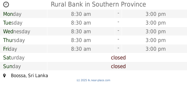
Rural Bank
Boossa
Bank
read more
3.044 km
Sanasa Society
Dodandugoda Road, Hikkaduwa
Bank
read more
3.276 km
People's Bank
A2, Dodanduwa
Bank
read more
3.453 km
Hegoda Rural Bank
Galle
Bank
read more
4.613 km
Horagampita Sanasa
Horagampita
Bank
read more
4.657 km
Pragdhana Bank Head Office Gintota
701B Colombo Road Gintota, Ginitota Plywood Factory Road, Galle
Bank
read more
4.661 km
People's Bank Gintota
71 Colombo - Galle Main Road, Galle
Bank
read more
4.919 km
සමෘද්ධි ප්රජාමූල බැංකුව
Dodanduwa - Gonapinuwala Road, Gonapinuwala
Bank
read more
5.227 km
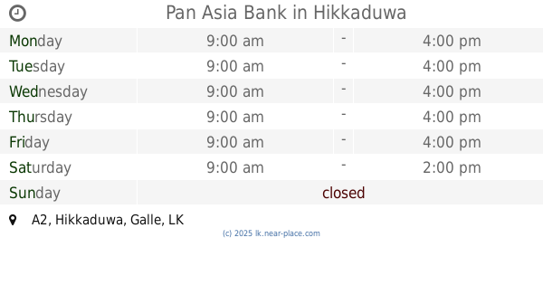
Pan Asia Bank
A2, Hikkaduwa
Bank
read more
5.604 km
Thelikada Sanasa Bank
Telikada
Bank
read more
5.721 km
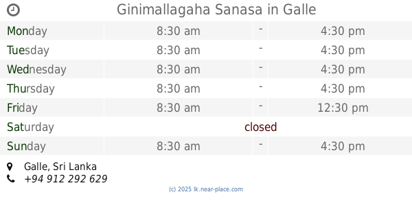
Ginimallagaha Sanasa
Galle
Bank
read more
6.587 km
Dadella Samurdhi Bank
Galle
Bank
read more
6.595 km
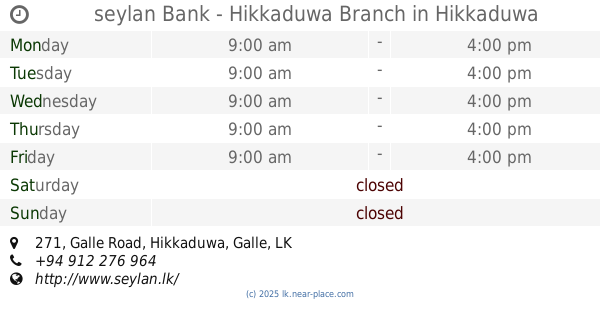
seylan Bank - Hikkaduwa Branch
271 Galle Road, Hikkaduwa
Bank
read more
7.561 km
Pragdhana Bank Hikkaduwa
Galle Road, Hikkaduwa
Bank
read more
7.854 km
DFCC bank - BADDEGAMA
No 73,Baddegama -Galle Road, Udakubura ,, Baddegama.
Bank
read more
8.82 km
Co-Op Bank
Dahanayaka Mawatha, Galle
Bank
read more
8.991 km
Godakanda North Sanasa Bank
Godakanda Narawala Road
Bank
read more
9.156 km
Rohana Credit (Pvt) Ltd
Godakanda Narawala Road, Baaswaththa
Bank
read more
10.356 km
hnb grameen
no.12,main street,galle
Bank
read more
10.9 km
Habib Bank
A2, Galle
Bank
read more
13.434 km
Pragdhana Bank Wanduramba
Wanduramba - Mapalagama Road, Wanduramba
Bank
read more
📑
all categories
Accounting
Administrative area level 1
Administrative area level 2
Airport
Amusement park
Aquarium
Art gallery
Atm
Bakery
Bank
Bar
Beauty salon
Bicycle store
Book store
Bowling alley
Bus station
Cafe
Campground
Car dealer
Car rental
Car repair
Car wash
Casino
Cemetery
Church
City hall
Clothing store
Colloquial area
Convenience store
Country
Courthouse
Dentist
Department store
Doctor
Electrician
Electronics store
Embassy
Finance
Fire station
Florist
Food
Funeral home
Furniture store
Gas station
General contractor
Grocery or supermarket
Gym
Hair care
Hardware store
Health
Hindu Temple
Home goods store
Hospital
Insurance agency
Intersection
Jewelry store
Laundry
Lawyer
Library
Light rail station
Liquor store
Local government office
Locality
Locksmith
Lodging
Meal delivery
Meal takeaway
Mosque
Movie rental
Movie theater
Moving company
Museum
Natural feature
Neighborhood
Night club
Painter
Park
Parking
Pet store
Pharmacy
Physiotherapist
Place of worship
Plumber
Point of interest
Police
Political
Post office
Premise
Real estate agency
Restaurant
Roofing contractor
Route
Rv park, camping
School
Shoe store
Shopping mall
Spa
Stadium
Storage
Store
Subpremise
Supermarket
Synagogue
Taxi stand
Train station
Transit station
Travel agency
University
Veterinary care
Zoo
administrative area level 3
sublocality level 1
sublocality level 2
↑