Bank nearby Regional Development Bank
Coronavirus disease (COVID-19) Situation
confirmed cases
672754
deaths
16897
Sri Lanka
Bank nearby Regional Development Bank
Regional Development Bank
Kolonnawa Road, 10600, Colombo, Western Province, LK Sri Lanka
contacts phone
:
+94 112 532 664
website:
www.rdb.lk
Latitude:
6.9323818
, Longitude:
79.8922321
larger map & directions
read more
nearest Bank
21 m
commercial bank
Bank
read more
119 m
HNB Bank
Kolonnawa Road, Sri Jayawardenepura Kotte
Bank
read more
121 m
Hatton National Bank
166 Kolonnawa Road, Colombo
Bank
read more
192 m
Bank Of Ceylon
Wijayapura
Bank
read more
219 m
Bank of Ceylon
Welikada
Bank
read more
241 m
People's Bank
Welikada
Bank
read more
252 m
Kolonnawa Co-operative Bank
Kolonnawa
Bank
read more
348 m
Amana Bank ATM - Kolannawa
Kolonnawa
Bank
read more
564 m
Sampath Bank
268 B231, Kotikawatta
Bank
read more
601 m
Cinema Select.
Kolonnawa Road, Colombo
Bank
read more
601 m
Cinema Select.
B96, Colombo
Bank
read more
757 m
People's Bank
B435
Bank
read more
864 m
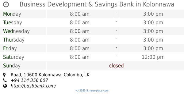
Business Development & Savings Bank
81, Road, Kolonnawa
Bank
read more
867 m
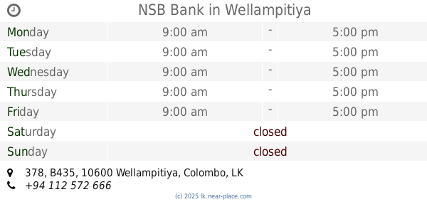
NSB Bank
378 B435, Wellampitiya
Bank
read more
1.314 km
Sanasa Bank
Kotikawatta
Bank
read more
1.514 km
Bank of Ceylon - Dematagoda
45,37 Kolonnawa Road, Colombo
Bank
read more
1.587 km
Hatton National Bank - Dematagoda
No. 284, Baseline Road,, කොළඹ
Bank
read more
1.661 km
Hatton National Bank
No-752, Dr Danister De Silva Mawatha,, Colombo
Bank
read more
1.698 km
Corporate Arcade Ltd
Alnitak Building, 422/37,, 752/5 බේස්ලයින් පාර, කොළඹ
Bank
read more
1.701 km
Commercial Bank Baseline Road Branch
No.658, Dr. Danister De Silva Mawatha,, Colombo
Bank
read more
1.925 km
Sampath Bank
Baseline Road, Colombo
Bank
read more
2.407 km
Bank of Ceylon Borella Branch
Doctor Danister De Silva Mawatha, Colombo
Bank
read more
2.508 km
Borella Jubilee Branch-Peoples Bank
1161, මරදාන පාර, කොළඹ
Bank
read more
2.519 km
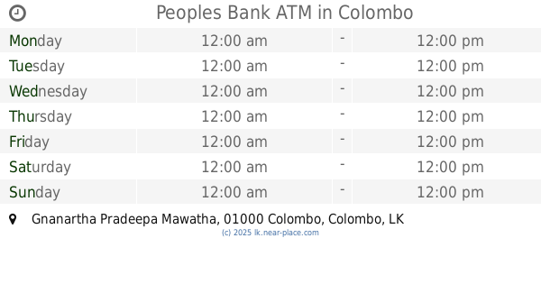
Peoples Bank ATM
Gnanartha Pradeepa Mawatha, Colombo
Bank
read more
2.573 km
National Savings Bank
Ward Place, Colombo
Bank
read more
📑
all categories
Accounting
Administrative area level 1
Administrative area level 2
Airport
Amusement park
Aquarium
Art gallery
Atm
Bakery
Bank
Bar
Beauty salon
Bicycle store
Book store
Bowling alley
Bus station
Cafe
Campground
Car dealer
Car rental
Car repair
Car wash
Casino
Cemetery
Church
City hall
Clothing store
Colloquial area
Convenience store
Country
Courthouse
Dentist
Department store
Doctor
Electrician
Electronics store
Embassy
Finance
Fire station
Florist
Food
Funeral home
Furniture store
Gas station
General contractor
Grocery or supermarket
Gym
Hair care
Hardware store
Health
Hindu Temple
Home goods store
Hospital
Insurance agency
Intersection
Jewelry store
Laundry
Lawyer
Library
Light rail station
Liquor store
Local government office
Locality
Locksmith
Lodging
Meal delivery
Meal takeaway
Mosque
Movie rental
Movie theater
Moving company
Museum
Natural feature
Neighborhood
Night club
Painter
Park
Parking
Pet store
Pharmacy
Physiotherapist
Place of worship
Plumber
Point of interest
Police
Political
Post office
Premise
Real estate agency
Restaurant
Roofing contractor
Route
Rv park, camping
School
Shoe store
Shopping mall
Spa
Stadium
Storage
Store
Subpremise
Supermarket
Synagogue
Taxi stand
Train station
Transit station
Travel agency
University
Veterinary care
Zoo
administrative area level 3
sublocality level 1
sublocality level 2
↑