Bank nearby Seylan Bank, Manipay Branch
Sri Lanka
Bank nearby Seylan Bank, Manipay Branch
Seylan Bank, Manipay Branch
103, Manipay-Kaitadi Road, Jaffna, Jaffna, LK Sri Lanka
contacts phone
:
+94
website:
www.seylan.lk
Latitude:
9.7224595
, Longitude:
79.9975655
larger map & directions
read more
nearest Bank
11 m
Sampath Bank
Manipay
Bank
read more
29 m
Bank Of Ceylon - Manipay
Jaffna-Manipay-Karainagar Road, Manipay
Bank
read more
51 m
National Savings Bank
No: 138 Sundarson Building, Jaffna Road AB17
Bank
read more
162 m
DFCC Bank
12 Mootha Thampy Lane, Manipay
Bank
read more
231 m
Hatton National Bank PLC
Manipay
Bank
read more
618 m
Peoples bank
Manipay
Bank
read more
620 m
Commercial Bank Manipay Branch
No 244 & 246, Yarl Road, Manipay
Bank
read more
659 m
National Development Bank
No 260, Manipay Road, Manipay
Bank
read more
975 m
Samurdhi Bank
Sri Lanka, Manipay
Bank
read more
1.909 km
Bank of Ceylon
Annamalai street chavalkaddu
Bank
read more
2.865 km
People's Bank
Jaffna-Kankesanturai Road
Bank
read more
2.973 km
Sanasa Development Bank
Jaffna-Kankesanturai Road, Jaffna
Bank
read more
3.238 km
People's Bank. Kokuvil
Jaffna
Bank
read more
3.451 km
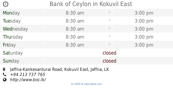
Bank of Ceylon
Jaffna-Kankesanturai Road, Kokuvil East
Bank
read more
3.468 km
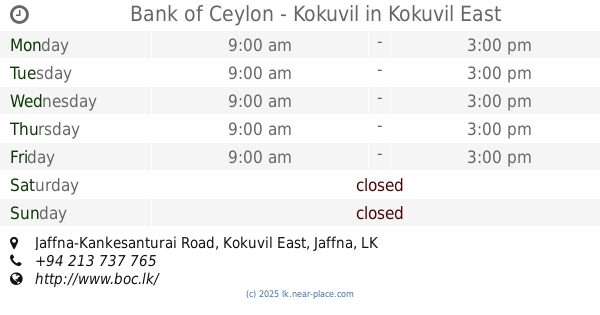
Bank of Ceylon - Kokuvil
Jaffna-Kankesanturai Road, Kokuvil East
Bank
read more
3.819 km
Bank of Ceylon - Chunnakam
146, Jaffna-Kankesanturai Road, Chunnakam
Bank
read more
3.916 km
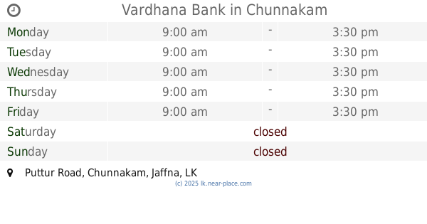
Vardhana Bank
Puttur Road, Chunnakam
Bank
read more
3.939 km
Seylan Bank
Kadduvan-Mallakam-Chankanai Road
Bank
read more
3.939 km
Seylan Bank
Kadduwan - Mallakam - Chankanai
Bank
read more
3.953 km
Sampath Bank Chankanai
Sri Lanka
Bank
read more
4.908 km
Sampath bank
Palali Road
Bank
read more
5.095 km
NDB bank
Kokuvil East
Bank
read more
5.099 km
Bank of Ceylon இலங்கை வங்கி
102, Palaly Road
Bank
read more
5.486 km
Bank of Ceylon
No51,K.K.S Road
Bank
read more
6.453 km
Bank of Ceylon Kalviyankaadu இலங்கை வங்கி கல்வியங்காடு
Kalviyankadu
Bank
read more
📑
all categories
Accounting
Administrative area level 1
Administrative area level 2
Airport
Amusement park
Aquarium
Art gallery
Atm
Bakery
Bank
Bar
Beauty salon
Bicycle store
Book store
Bowling alley
Bus station
Cafe
Campground
Car dealer
Car rental
Car repair
Car wash
Casino
Cemetery
Church
City hall
Clothing store
Colloquial area
Convenience store
Country
Courthouse
Dentist
Department store
Doctor
Electrician
Electronics store
Embassy
Finance
Fire station
Florist
Food
Funeral home
Furniture store
Gas station
General contractor
Grocery or supermarket
Gym
Hair care
Hardware store
Health
Hindu Temple
Home goods store
Hospital
Insurance agency
Intersection
Jewelry store
Laundry
Lawyer
Library
Light rail station
Liquor store
Local government office
Locality
Locksmith
Lodging
Meal delivery
Meal takeaway
Mosque
Movie rental
Movie theater
Moving company
Museum
Natural feature
Neighborhood
Night club
Painter
Park
Parking
Pet store
Pharmacy
Physiotherapist
Place of worship
Plumber
Point of interest
Police
Political
Post office
Premise
Real estate agency
Restaurant
Roofing contractor
Route
Rv park, camping
School
Shoe store
Shopping mall
Spa
Stadium
Storage
Store
Subpremise
Supermarket
Synagogue
Taxi stand
Train station
Transit station
Travel agency
University
Veterinary care
Zoo
administrative area level 3
sublocality level 1
sublocality level 2
↑