Bar nearby Diamond Wine Stores
Coronavirus disease (COVID-19) Situation
confirmed cases
672754
deaths
16897
Sri Lanka
Bar nearby Diamond Wine Stores
Diamond Wine Stores
A26, 20168, Nattarampota, Kandy, LK Sri Lanka
contacts phone
:
+94
Latitude:
7.2799614
, Longitude:
80.6764966
larger map & directions
read more
nearest Bar
124 m
Fine Spirits Wine Shop
A26, Nattarampota
Bar
read more
128 m
G.M.T Wine City
A26, Nattarampota
Bar
read more
3.621 km
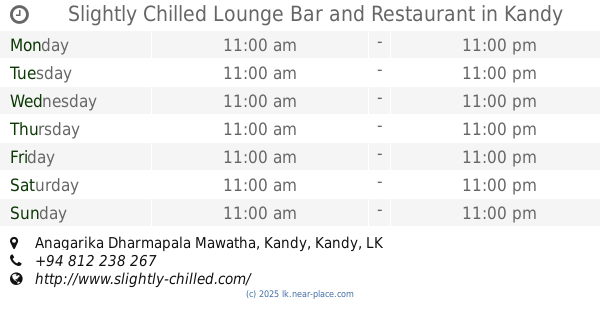
Slightly Chilled Lounge Bar and Restaurant
Anagarika Dharmapala Mawatha, Kandy
Bar
read more
4.573 km
Victory Hotel & Bar
79, Kandy
Bar
read more
4.574 km
Cargills Liquor Outlet
East L Senanayake Veediya, Kandy
Bar
read more
4.614 km
Royal Bar & Hotel
No.44 Kings street, Raja Veediya, Kandy
Bar
read more
4.665 km
The PUB
Sri Dalada Veediya, Kandy
Bar
read more
4.866 km
Pavana
Wadugodapitiya Lane, Kandy
Bar
read more
4.9 km
Cosey Liquer Shop
Kandy
Bar
read more
4.923 km
Crown Wine Store
Menikhinna
Bar
read more
5.046 km
Old Trinitian's Sports Club
Adahanamaluwa Road, Kandy
Bar
read more
6.174 km
Mini Pub
546 Peradeniya Road, Kandy
Bar
read more
6.727 km
Digana Wine stores
Digana
Bar
read more
7.409 km
Raa Hut
390 Srimath Kudarathwatta Mawatha, Kandy
Bar
read more
7.627 km
MACHAN PERADENIYA
Sri Amarawansa Mawatha, Kandy
Bar
read more
7.691 km
Tavern 29 Rooftop Bar
11, Deveni Rajasinghe Mawatha, Kandy
Bar
read more
9.296 km
Shanaka Beer House
Orutota
Bar
read more
10.23 km
Lucky Wine Stores
18, Peradeniya-Deltota-Rikiligaskada Road, Galaha
Bar
read more
10.498 km
Kuruppuarachchi Wine Stores
A1
Bar
read more
12.041 km
Muruthalwa vine stores
Muruthalawa
Bar
read more
13.675 km
Imalka vine store
Adhikarigama
Bar
read more
14.808 km
Madulkelle Wine Stores
Madulkelle - Kabaragala - Kandenuwara
Bar
read more
14.846 km
MEDAWELA BEER HOUSE
Hedeniya - Medawela - Poojapitiya Road, Medawala
Bar
read more
17.461 km
Rukman Restaurant
Gampola
Bar
read more
17.8 km
Thilanka Wine Stores
Gampola
Bar
read more
📑
all categories
Accounting
Administrative area level 1
Administrative area level 2
Airport
Amusement park
Aquarium
Art gallery
Atm
Bakery
Bank
Bar
Beauty salon
Bicycle store
Book store
Bowling alley
Bus station
Cafe
Campground
Car dealer
Car rental
Car repair
Car wash
Casino
Cemetery
Church
City hall
Clothing store
Colloquial area
Convenience store
Country
Courthouse
Dentist
Department store
Doctor
Electrician
Electronics store
Embassy
Finance
Fire station
Florist
Food
Funeral home
Furniture store
Gas station
General contractor
Grocery or supermarket
Gym
Hair care
Hardware store
Health
Hindu Temple
Home goods store
Hospital
Insurance agency
Intersection
Jewelry store
Laundry
Lawyer
Library
Light rail station
Liquor store
Local government office
Locality
Locksmith
Lodging
Meal delivery
Meal takeaway
Mosque
Movie rental
Movie theater
Moving company
Museum
Natural feature
Neighborhood
Night club
Painter
Park
Parking
Pet store
Pharmacy
Physiotherapist
Place of worship
Plumber
Point of interest
Police
Political
Post office
Premise
Real estate agency
Restaurant
Roofing contractor
Route
Rv park, camping
School
Shoe store
Shopping mall
Spa
Stadium
Storage
Store
Subpremise
Supermarket
Synagogue
Taxi stand
Train station
Transit station
Travel agency
University
Veterinary care
Zoo
administrative area level 3
sublocality level 1
sublocality level 2
↑