Cafe nearby ATI Canteen
Coronavirus disease (COVID-19) Situation
confirmed cases
672754
deaths
16897
Sri Lanka
Cafe nearby ATI Canteen
ATI Canteen
Galle, Sri Lanka
contacts phone
:
+94
Latitude:
6.0744789
, Longitude:
80.233915
larger map & directions
read more
nearest Cafe
591 m
Bake Cabin
26 H.K. Edmond Mawatha, Galle
Cafe
read more
607 m
Sulalitha Hotel
B248, Galle
Cafe
read more
1.09 km
Samali
Welipatha, Galle
Cafe
read more
1.258 km
Hiland Milk Bar - Karapitiya Teaching Hospital
Galle
Cafe
read more
1.277 km
Canteen - Teaching Hospital Karapitiya
Galle
Cafe
read more
1.744 km
Sha Bakes
Galle
Cafe
read more
1.947 km
Nethmina Hotel
No 532, Kalegana Road, Galle
Cafe
read more
1.948 km
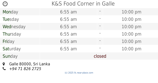
K&S Food Corner
Galle
Cafe
read more
2.404 km
Padmasiri Hotel
B128, Galle
Cafe
read more
2.439 km
SHA.COM COMMUNICATION
Galle - Baddegama Road, Galle
Cafe
read more
2.455 km
Sahana
Galle
Cafe
read more
2.992 km
Chathu Food Corner
Poddala
Cafe
read more
2.992 km
Vista Steel Art
Poddala
Cafe
read more
3.716 km
Havana Cool Spot
Wakwella Road, Galle
Cafe
read more
3.716 km
Fresh Juce Corner
Wakwella Road, Galle
Cafe
read more
3.745 km
Iduwara cafe
20 Galle - Udugama Road, Galle
Cafe
read more
4.41 km
FRESH juice Bar
Galle
Cafe
read more
4.493 km
Cafe 86
86 Wakwella Road, Galle
Cafe
read more
4.517 km
Rococo ICE Cream Parlour
Galle
Cafe
read more
4.617 km
Cafe BlackRose
No452 Matara Road, Galle
Cafe
read more
4.767 km
Bake 'n' Take
No 137, Main Street, Galle.
Cafe
read more
4.854 km
Ak's Palace
Bope Cross Road, Galle
Cafe
read more
4.94 km
The Old Railway
42 Havelock Road, Galle
Cafe
read more
4.958 km
Bubble Bee Cafe
32 Havelock Road, Galle
Cafe
read more
4.981 km
Sirimal Cafe
Colombo - Galle Main Road, Galle
Cafe
read more
📑
all categories
Accounting
Administrative area level 1
Administrative area level 2
Airport
Amusement park
Aquarium
Art gallery
Atm
Bakery
Bank
Bar
Beauty salon
Bicycle store
Book store
Bowling alley
Bus station
Cafe
Campground
Car dealer
Car rental
Car repair
Car wash
Casino
Cemetery
Church
City hall
Clothing store
Colloquial area
Convenience store
Country
Courthouse
Dentist
Department store
Doctor
Electrician
Electronics store
Embassy
Finance
Fire station
Florist
Food
Funeral home
Furniture store
Gas station
General contractor
Grocery or supermarket
Gym
Hair care
Hardware store
Health
Hindu Temple
Home goods store
Hospital
Insurance agency
Intersection
Jewelry store
Laundry
Lawyer
Library
Light rail station
Liquor store
Local government office
Locality
Locksmith
Lodging
Meal delivery
Meal takeaway
Mosque
Movie rental
Movie theater
Moving company
Museum
Natural feature
Neighborhood
Night club
Painter
Park
Parking
Pet store
Pharmacy
Physiotherapist
Place of worship
Plumber
Point of interest
Police
Political
Post office
Premise
Real estate agency
Restaurant
Roofing contractor
Route
Rv park, camping
School
Shoe store
Shopping mall
Spa
Stadium
Storage
Store
Subpremise
Supermarket
Synagogue
Taxi stand
Train station
Transit station
Travel agency
University
Veterinary care
Zoo
administrative area level 3
sublocality level 1
sublocality level 2
↑