Cafe nearby Milk Hut
Coronavirus disease (COVID-19) Situation
confirmed cases
672754
deaths
16897
Sri Lanka
Cafe nearby Milk Hut
Milk Hut
Makola - Udupila Road, Gampaha, Western Province, LK Sri Lanka
contacts phone
:
+94
Latitude:
6.9825931
, Longitude:
79.9856806
larger map & directions
read more
nearest Cafe
3.089 km
Raththarange Appa Kade
Webada Road
Cafe
read more
3.414 km
Amal hotel
Biyagama North
Cafe
read more
3.42 km
RED HUT
KADAWATHA
Cafe
read more
3.654 km
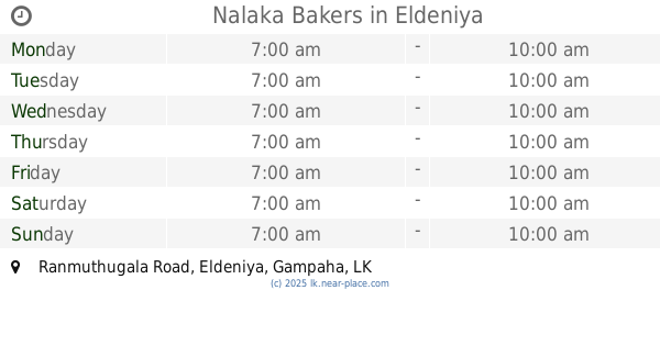
Nalaka Bakers
Ranmuthugala Road, Eldeniya
Cafe
read more
3.689 km
Keti Kama
Madatiyagahawatta Road, Eldeniya
Cafe
read more
3.858 km
Sirikatha Grocery
A1, Kadawatha
Cafe
read more
3.891 km
Stage Cafe
Colombo - Kandy Road, Eldeniya
Cafe
read more
4.05 km
Priyangika Hotel
Kadawatha
Cafe
read more
4.135 km
Isuru Hotel
kadawatha Town, Kadawatha
Cafe
read more
4.164 km
Cake Bar
Ihala Biyanvila
Cafe
read more
4.42 km
Don & Sons
Kandy Road, Kadawatha
Cafe
read more
4.434 km
Aradhana Hotel
172/12/A, A1, Kadawatha
Cafe
read more
4.434 km
Aradhana Hotel
172/12/A, Kandy Road, Kadawatha
Cafe
read more
4.544 km
Polhena Kade
B25, Ranaviru Gama
Cafe
read more
4.718 km
Surasa Gammadda
No. 193, 9th Post, Kandy Road,, Kadawatha
Cafe
read more
4.74 km
SriKantha Subasinghe
410/B/4, B161, Kadawatha
Cafe
read more
4.781 km
Randula Grand Venus Hotel
39/3, Kandy Road, Kirillawala, Kadawatha
Cafe
read more
4.836 km
Sanjula Food
148, Gonawala Road, பேலியகொடை
Cafe
read more
4.843 km
Swarna Bakehouse
B13, Kadawatha
Cafe
read more
4.936 km
Cool Drinks
Biyagama South
Cafe
read more
4.992 km
Sky Way Designer Kirillawala
Kadawatha
Cafe
read more
5.641 km
CNS Family Rest
Naranwala
Cafe
read more
5.789 km
Zoo Cafe
Welivita Road, Kaduwela
Cafe
read more
13.128 km
Rapid Fresh Cafe
Thalawathugoda, East
Cafe
read more
16.595 km
Bubble Me Bubble Tea
106 Ven. Muruththettuwe Ananda Himi Mawatha, Colombo
Cafe
read more
📑
all categories
Accounting
Administrative area level 1
Administrative area level 2
Airport
Amusement park
Aquarium
Art gallery
Atm
Bakery
Bank
Bar
Beauty salon
Bicycle store
Book store
Bowling alley
Bus station
Cafe
Campground
Car dealer
Car rental
Car repair
Car wash
Casino
Cemetery
Church
City hall
Clothing store
Colloquial area
Convenience store
Country
Courthouse
Dentist
Department store
Doctor
Electrician
Electronics store
Embassy
Finance
Fire station
Florist
Food
Funeral home
Furniture store
Gas station
General contractor
Grocery or supermarket
Gym
Hair care
Hardware store
Health
Hindu Temple
Home goods store
Hospital
Insurance agency
Intersection
Jewelry store
Laundry
Lawyer
Library
Light rail station
Liquor store
Local government office
Locality
Locksmith
Lodging
Meal delivery
Meal takeaway
Mosque
Movie rental
Movie theater
Moving company
Museum
Natural feature
Neighborhood
Night club
Painter
Park
Parking
Pet store
Pharmacy
Physiotherapist
Place of worship
Plumber
Point of interest
Police
Political
Post office
Premise
Real estate agency
Restaurant
Roofing contractor
Route
Rv park, camping
School
Shoe store
Shopping mall
Spa
Stadium
Storage
Store
Subpremise
Supermarket
Synagogue
Taxi stand
Train station
Transit station
Travel agency
University
Veterinary care
Zoo
administrative area level 3
sublocality level 1
sublocality level 2
↑