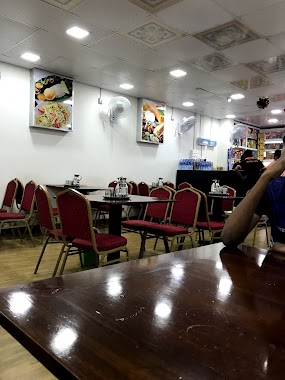
Cafe nearby Pink Oven
Coronavirus disease (COVID-19) Situation
confirmed cases
672754
deaths
16897
Sri Lanka
Cafe nearby Pink Oven
Pink Oven
Kerawalapitiya Road, Wattala, Gampaha, LK Sri Lanka
contacts phone
:
+94
Latitude:
7.009875
, Longitude:
79.8887342
larger map & directions
read more
nearest Cafe
1.05 km
Thaj Hotel
Wattala
Cafe
read more
1.051 km
Al Umma's
Magammana
Cafe
read more
1.088 km
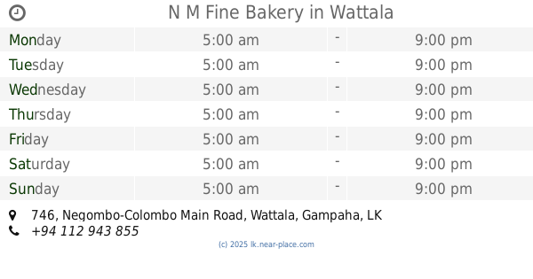
N M Fine Bakery
746 Negombo-Colombo Main Road, Wattala
Cafe
read more
1.481 km
Sampath Foods
Hendala Road, Wattala
Cafe
read more
1.523 km
Maththumagala Snack Bar
Negombo-Colombo Main Road
Cafe
read more
1.745 km
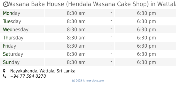
Wasana Bake House (Hendala Wasana Cake Shop)
Wattala
Cafe
read more
1.757 km
SEEDS
Gampaha
Cafe
read more
1.964 km
Pathum Bakery
Old Dispensary Road, Wattala
Cafe
read more
2.039 km
Seeds Juice Station
520B Negombo-Colombo Main Road, Wattala
Cafe
read more
2.1 km
Krish cafe
Hendala South, Wattala
Cafe
read more
2.23 km
Welisara Chest Hospital
Welisara Chest Hospital Road, Welisara
Cafe
read more
2.25 km
Green House Tea Exports Ceylon (Pvt) Ltd
No.41, Elakanda Road, Hendala, Wattala
Cafe
read more
2.273 km
Perera & Sons
39, Hendala Road, Wattala
Cafe
read more
2.343 km
Jayamaha Bakery Road
Weliamuna Road, Wattala
Cafe
read more
2.483 km
Golden Cafe Pure Vegetarian Cafe
366 Negombo Road, Wattala
Cafe
read more
2.531 km
Mints Foods
129b Old Negombo Road, Wattala
Cafe
read more
2.734 km
Lyceum Wattala Canteen
Wattala
Cafe
read more
2.848 km
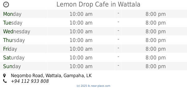
Lemon Drop Cafe
No. 305A, Negombo Road, Wattala
Cafe
read more
3.172 km
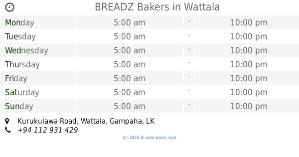
BREADZ Bakers
1190/4 11300, Kurukulawa Road, Wattala
Cafe
read more
3.179 km
cake frills by Nisha
Magulpokuna Road, Ragama
Cafe
read more
3.204 km
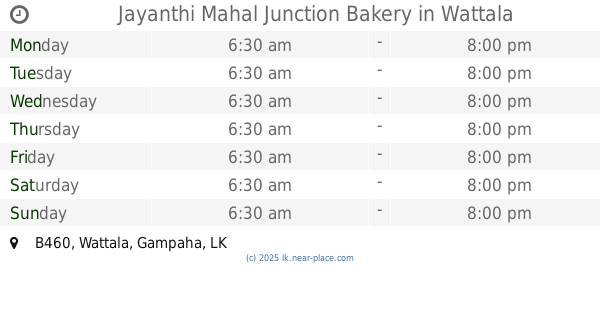
Jayanthi Mahal Junction Bakery
B460, Wattala
Cafe
read more
3.361 km
We Can Juice Bar
Ragama
Cafe
read more
3.473 km
Madurawala Niwahana
74/40, Kandana
Cafe
read more
3.616 km
Skynet Communication Center in Ragama
Skynet Communication Center in Ragama, Peralanda Road, Ragama
Cafe
read more
3.619 km
Dill Food
Peralanda Road, Ragama
Cafe
read more
📑
all categories
Accounting
Administrative area level 1
Administrative area level 2
Airport
Amusement park
Aquarium
Art gallery
Atm
Bakery
Bank
Bar
Beauty salon
Bicycle store
Book store
Bowling alley
Bus station
Cafe
Campground
Car dealer
Car rental
Car repair
Car wash
Casino
Cemetery
Church
City hall
Clothing store
Colloquial area
Convenience store
Country
Courthouse
Dentist
Department store
Doctor
Electrician
Electronics store
Embassy
Finance
Fire station
Florist
Food
Funeral home
Furniture store
Gas station
General contractor
Grocery or supermarket
Gym
Hair care
Hardware store
Health
Hindu Temple
Home goods store
Hospital
Insurance agency
Intersection
Jewelry store
Laundry
Lawyer
Library
Light rail station
Liquor store
Local government office
Locality
Locksmith
Lodging
Meal delivery
Meal takeaway
Mosque
Movie rental
Movie theater
Moving company
Museum
Natural feature
Neighborhood
Night club
Painter
Park
Parking
Pet store
Pharmacy
Physiotherapist
Place of worship
Plumber
Point of interest
Police
Political
Post office
Premise
Real estate agency
Restaurant
Roofing contractor
Route
Rv park, camping
School
Shoe store
Shopping mall
Spa
Stadium
Storage
Store
Subpremise
Supermarket
Synagogue
Taxi stand
Train station
Transit station
Travel agency
University
Veterinary care
Zoo
administrative area level 3
sublocality level 1
sublocality level 2
↑