Cemetery nearby PUWKPITIYA CEMETERY
Coronavirus disease (COVID-19) Situation
confirmed cases
672754
deaths
16897
Sri Lanka
Cemetery nearby PUWKPITIYA CEMETERY
PUWKPITIYA CEMETERY
Sri Lanka
contacts phone
:
+94 77 828 9844
Latitude:
6.9312623
, Longitude:
80.18766
larger map & directions
read more
nearest Cemetery
2.727 km
Avissawella General Cemetery
Avissawella
Cemetery
read more
7.487 km
Philip Gunawardena Cemetery
Boralugoda Road, Pannipitiya
Cemetery
read more
7.633 km
Akaravita Cemetrey
Sri Lanka
Cemetery
read more
8.006 km
Cemetery
B188
Cemetery
read more
8.265 km
Nissanka Jayasinghe Cemetry
Sri Lanka
Cemetery
read more
8.427 km
Bollathawa Cemetery
Bollathawa
Cemetery
read more
9.042 km
Kaluaggala Cemetery
Kolombo
Cemetery
read more
9.042 km
Kaluaggala Cemetery
Colombo
Cemetery
read more
10.345 km
Iriyagolla Public Cemetery
Sri Lanka
Cemetery
read more
11.042 km
Walpola Cemetery
Sri Lanka
Cemetery
read more
12.171 km
Hanwella Cemetery
Hanwella
Cemetery
read more
13.889 km
Wahakula Public Cemetry
Nittambuwa - Ruwanwella Road
Cemetery
read more
14.212 km
Cemetery, Welgama
Hanwella Malwana Road, Seethawakapura
Cemetery
read more
14.284 km
Public Cemetery - Kirindiwela
Gampaha
Cemetery
read more
14.509 km
Public Cemetery
Ruwanwella
Cemetery
read more
14.761 km
Cemetry
Sri Lanka
Cemetery
read more
15.298 km
Cemetery Meeriyagalla
Padukka
Cemetery
read more
15.425 km
Cemetery
Padukka
Cemetery
read more
16.305 km
Cemetery Yatiyanthota
Yatiyanthota
Cemetery
read more
16.689 km
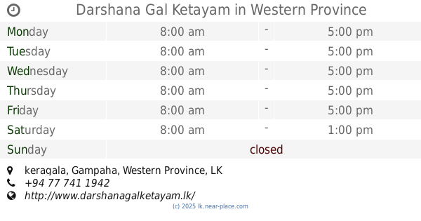
Darshana Gal Ketayam
keragala
Cemetery
read more
16.725 km
Public Cemetery Ruwanwella
Ruwanwella
Cemetery
read more
17.213 km
Poregedara Cemetery
Padukka
Cemetery
read more
17.515 km
Public Cemetery
Padukka
Cemetery
read more
17.592 km
Watareka Public Cemetery
Watareka
Cemetery
read more
18.71 km
Hiripitiya Cemetery
Wathurugama Road, Batepola
Cemetery
read more
📑
all categories
Accounting
Administrative area level 1
Administrative area level 2
Airport
Amusement park
Aquarium
Art gallery
Atm
Bakery
Bank
Bar
Beauty salon
Bicycle store
Book store
Bowling alley
Bus station
Cafe
Campground
Car dealer
Car rental
Car repair
Car wash
Casino
Cemetery
Church
City hall
Clothing store
Colloquial area
Convenience store
Country
Courthouse
Dentist
Department store
Doctor
Electrician
Electronics store
Embassy
Finance
Fire station
Florist
Food
Funeral home
Furniture store
Gas station
General contractor
Grocery or supermarket
Gym
Hair care
Hardware store
Health
Hindu Temple
Home goods store
Hospital
Insurance agency
Intersection
Jewelry store
Laundry
Lawyer
Library
Light rail station
Liquor store
Local government office
Locality
Locksmith
Lodging
Meal delivery
Meal takeaway
Mosque
Movie rental
Movie theater
Moving company
Museum
Natural feature
Neighborhood
Night club
Painter
Park
Parking
Pet store
Pharmacy
Physiotherapist
Place of worship
Plumber
Point of interest
Police
Political
Post office
Premise
Real estate agency
Restaurant
Roofing contractor
Route
Rv park, camping
School
Shoe store
Shopping mall
Spa
Stadium
Storage
Store
Subpremise
Supermarket
Synagogue
Taxi stand
Train station
Transit station
Travel agency
University
Veterinary care
Zoo
administrative area level 3
sublocality level 1
sublocality level 2
↑