Church nearby Minneriya Catholic church
Coronavirus disease (COVID-19) Situation
confirmed cases
672754
deaths
16897
Sri Lanka
Church nearby Minneriya Catholic church
Minneriya Catholic church
Distrito de Polonnaruwa Sri Lanka
contacts phone
:
+94
Latitude:
8.0343003
, Longitude:
80.9050755
read more
nearest Church
Minneriya Catholic church
Polonnaruwa
Church
read more
6.792 km
Christ the King Catholic Church
Hingurakgoda
Church
read more
11.43 km
St. Sebastian Church
Laksha Uyana - Chandana Pokuna
Church
read more
15.597 km
Mary Immaculate Church
Church Road, Polonnaruwa
Church
read more
15.762 km
Palugasdamana Church
Palugasdamana
Church
read more
15.859 km
St. Anthony's Church Thopawewa
Polonnaruwa
Church
read more
17.111 km
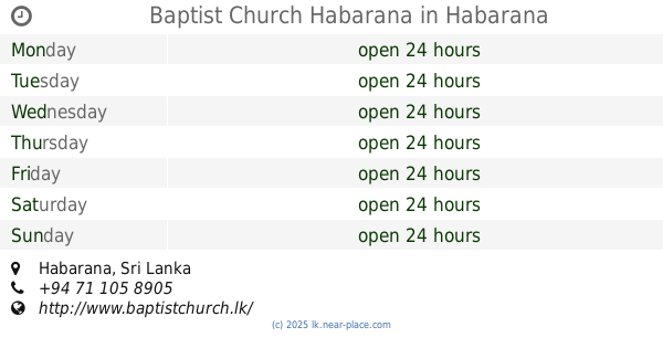
Baptist Church Habarana
Habarana
Church
read more
21.178 km
St. Sebastian Church
Lenawa Road, Sigirimulla, Dambulla
Church
read more
21.851 km
St. Sebastian Church
Unnamed Road, Dambulla
Church
read more
23.168 km
Sindathriya Maria Church
Dambulla
Church
read more
25.936 km
St. Anthony's Church
Dambulla
Church
read more
25.942 km
St. Antony's Church Inamaluwa
Dambulla
Church
read more
31.408 km
St. Anthonys Church
Ganewelpola - Dachchahalmillewa Road
Church
read more
33.719 km
Catholic Church Kekirawa
Jayanthi Road, Kekirawa
Church
read more
34.048 km
Kekirawa Baptist Church
Talawa Road, Kekirawa
Church
read more
38.493 km
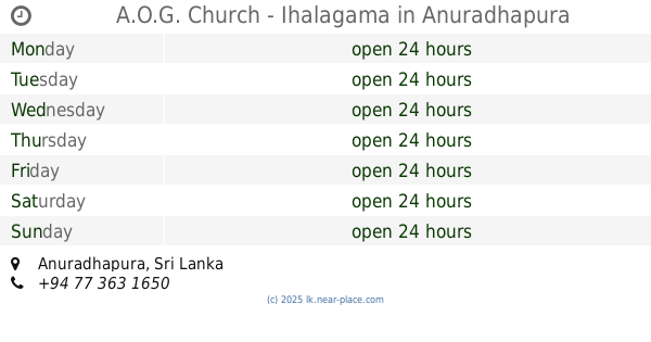
A.O.G. Church - Ihalagama
Anuradhapura
Church
read more
38.926 km
Methodist Church Deevargama
Trincomalee
Church
read more
47.696 km
Siyabalagahawela Church.
Matale
Church
read more
50.042 km
St.Anne's Catholic Church
Kahatagasdigiliya
Church
read more
52.09 km
Lady Madhu Shrine (Maduru Oya)
Polonnaruwa
Church
read more
56.337 km
St. Anthony's Church
A9, Mihintale
Church
read more
58.388 km
Moroththa Church- Mother Mary
Madahapola - Halmillagolla Colony Road
Church
read more
60.184 km
St. Jude's Church
Ashokapura road, Kannattiya, Mihintale
Church
read more
60.738 km
St Anthonys Church
Mutur
Church
read more
63.231 km
Rabawa Church
Rambewa
Church
read more
📑
all categories
Accounting
Administrative area level 1
Administrative area level 2
Airport
Amusement park
Aquarium
Art gallery
Atm
Bakery
Bank
Bar
Beauty salon
Bicycle store
Book store
Bowling alley
Bus station
Cafe
Campground
Car dealer
Car rental
Car repair
Car wash
Casino
Cemetery
Church
City hall
Clothing store
Colloquial area
Convenience store
Country
Courthouse
Dentist
Department store
Doctor
Electrician
Electronics store
Embassy
Finance
Fire station
Florist
Food
Funeral home
Furniture store
Gas station
General contractor
Grocery or supermarket
Gym
Hair care
Hardware store
Health
Hindu Temple
Home goods store
Hospital
Insurance agency
Intersection
Jewelry store
Laundry
Lawyer
Library
Light rail station
Liquor store
Local government office
Locality
Locksmith
Lodging
Meal delivery
Meal takeaway
Mosque
Movie rental
Movie theater
Moving company
Museum
Natural feature
Neighborhood
Night club
Painter
Park
Parking
Pet store
Pharmacy
Physiotherapist
Place of worship
Plumber
Point of interest
Police
Political
Post office
Premise
Real estate agency
Restaurant
Roofing contractor
Route
Rv park, camping
School
Shoe store
Shopping mall
Spa
Stadium
Storage
Store
Subpremise
Supermarket
Synagogue
Taxi stand
Train station
Transit station
Travel agency
University
Veterinary care
Zoo
administrative area level 3
sublocality level 1
sublocality level 2
↑