Church nearby Our Lady of Refuge Church
Sri Lanka
Church nearby Our Lady of Refuge Church
Our Lady of Refuge Church
Eluthoor, Mannar Sri Lanka
contacts phone
:
+94
Latitude:
8.9907933
, Longitude:
79.8932933
read more
nearest Church
418 m
Church of The Lord Jesus Christ
Mannar
Church
read more
947 m
Lanka Christian Fellowship Church
3rd Lane,, Periyakamam,, Mannar
Church
read more
982 m
Infant Jesus Church
Mannar
Church
read more
1.202 km
Ceylon Penthacostal Misson
Medawachchiya-Talaimannar Highway, Mannar
Church
read more
1.319 km
Our Lady of Madhu Minor Seminary
Minor Seminary Road, Mannar
Church
read more
1.399 km
My Saviour's Church
Mannar
Church
read more
1.424 km
St. Anthony's Church
Mannar
Church
read more
1.511 km
St Anthony Church
Mannar
Church
read more
1.59 km
GTCG Church
Mannar
Church
read more
1.718 km
Our Lady of Good Health Church
Mannar
Church
read more
1.838 km
Kurusu Kovil Christian Church
New Moor Street, Mannar
Church
read more
1.866 km
St Mary's Church
A14, Mannar
Church
read more
1.922 km
Joseph Catechetical Centre
Saint Sebastian's Street, Mannar
Church
read more
1.965 km
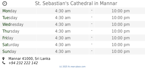
St. Sebastian's Cathedral
Mannar
Church
read more
1.966 km
Christ the King Church
Mannar
Church
read more
2.664 km
St Mary Church
Mannar
Church
read more
3.026 km
St. Joseph's Church
Thalvupadu, Mannar
Church
read more
3.057 km
Zion Gospel Church
Unnamed Road, Mannar
Church
read more
3.069 km
St Joseph Vaz Church
Mannar
Church
read more
3.169 km
Annai Velankanni Church
Mannar
Church
read more
3.684 km
St.Lucia's Church
Pallimunai, Mannar
Church
read more
5.719 km
Queen of Martyrs Church
Thoddavely, Medawachchiya-Talaimannar Highway
Church
read more
6.18 km
Konnayan Kudiyruppu Church
Olaiththoduvai Rd, Konnayan kudiyruppu
Church
read more
13.66 km
Our Lady Of Presentation Church Thullukudiyiruppu
Thullukudiyiruppu
Church
read more
14.828 km
St.Joseph church
Sri Lanka
Church
read more
📑
all categories
Accounting
Administrative area level 1
Administrative area level 2
Airport
Amusement park
Aquarium
Art gallery
Atm
Bakery
Bank
Bar
Beauty salon
Bicycle store
Book store
Bowling alley
Bus station
Cafe
Campground
Car dealer
Car rental
Car repair
Car wash
Casino
Cemetery
Church
City hall
Clothing store
Colloquial area
Convenience store
Country
Courthouse
Dentist
Department store
Doctor
Electrician
Electronics store
Embassy
Finance
Fire station
Florist
Food
Funeral home
Furniture store
Gas station
General contractor
Grocery or supermarket
Gym
Hair care
Hardware store
Health
Hindu Temple
Home goods store
Hospital
Insurance agency
Intersection
Jewelry store
Laundry
Lawyer
Library
Light rail station
Liquor store
Local government office
Locality
Locksmith
Lodging
Meal delivery
Meal takeaway
Mosque
Movie rental
Movie theater
Moving company
Museum
Natural feature
Neighborhood
Night club
Painter
Park
Parking
Pet store
Pharmacy
Physiotherapist
Place of worship
Plumber
Point of interest
Police
Political
Post office
Premise
Real estate agency
Restaurant
Roofing contractor
Route
Rv park, camping
School
Shoe store
Shopping mall
Spa
Stadium
Storage
Store
Subpremise
Supermarket
Synagogue
Taxi stand
Train station
Transit station
Travel agency
University
Veterinary care
Zoo
administrative area level 3
sublocality level 1
sublocality level 2
↑