Church nearby St. Mary's Church
Coronavirus disease (COVID-19) Situation
confirmed cases
672754
deaths
16897
Sri Lanka
Church nearby St. Mary's Church
St. Mary's Church
Ja-Ela, Sri Lanka
contacts phone
:
+94
Latitude:
7.0432407
, Longitude:
79.8595205
larger map & directions
read more
nearest Church
1.406 km
Calvary Church
Church Road, Bopitiya
Church
read more
1.429 km
Calvary Church
Bopitiya
Church
read more
1.68 km
St. Anthoney's Church - Pubudugama
Bopitiya Kandana Road, Bopitiya
Church
read more
1.772 km
Beracah Prayer House.
Bopitiya
Church
read more
3.216 km
St.Joachim's Church
KalaEliya Road, Ja-Ela
Church
read more
3.62 km
Egodawatta St.Anthony Church.
Ja-Ela
Church
read more
3.875 km
Christ The King Gospel Ministry
11350 No, 30. wellikurunduwatta kappuwatta Sri Lanka, Ja-Ela
Church
read more
3.92 km
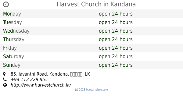
Harvest Church
85 Jayanthi Road, Kandana
Church
read more
3.989 km
Church of Our Lady of Fatima
Fatima Road, Ja-Ela
Church
read more
4.075 km
Gethsemane Church, Kandana
Kandana
Church
read more
4.08 km
St. John The Baptist Catholic Church
Kandana, Welisara
Church
read more
4.331 km
St. Anne Church
Ja-Ela
Church
read more
4.39 km
Lanka Gospel
No.239, Samagi Mawatha, Welisara, Ragama
Church
read more
4.466 km
Belivers Church Colombo Diocese
Kandana
Church
read more
4.832 km
Balagala Church
Wattala
Church
read more
4.855 km
Aniyakanda Church
Welesara
Church
read more
4.873 km
St.Roches Church
Delathura
Church
read more
4.976 km
Korean Union Church
Prithipura Road, Wattala
Church
read more
5.347 km
St. Anthony's Church Batagama - බටගම සාන්ත අන්තෝනි දේවස්ථානය
Ja-Ela
Church
read more
5.388 km
St. Clare's Church
Ja-Ela
Church
read more
5.74 km
Calvary Church Mabola
Bangalawatte Road, Wattala
Church
read more
6.278 km
CPM Ja-ela
Ja-Ela
Church
read more
6.311 km
St. Joesph Church
Ja-Ela
Church
read more
6.311 km
St. Joesph ⛪
Ja-Ela
Church
read more
6.405 km
Maeliya Church
Ja-Ela
Church
read more
📑
all categories
Accounting
Administrative area level 1
Administrative area level 2
Airport
Amusement park
Aquarium
Art gallery
Atm
Bakery
Bank
Bar
Beauty salon
Bicycle store
Book store
Bowling alley
Bus station
Cafe
Campground
Car dealer
Car rental
Car repair
Car wash
Casino
Cemetery
Church
City hall
Clothing store
Colloquial area
Convenience store
Country
Courthouse
Dentist
Department store
Doctor
Electrician
Electronics store
Embassy
Finance
Fire station
Florist
Food
Funeral home
Furniture store
Gas station
General contractor
Grocery or supermarket
Gym
Hair care
Hardware store
Health
Hindu Temple
Home goods store
Hospital
Insurance agency
Intersection
Jewelry store
Laundry
Lawyer
Library
Light rail station
Liquor store
Local government office
Locality
Locksmith
Lodging
Meal delivery
Meal takeaway
Mosque
Movie rental
Movie theater
Moving company
Museum
Natural feature
Neighborhood
Night club
Painter
Park
Parking
Pet store
Pharmacy
Physiotherapist
Place of worship
Plumber
Point of interest
Police
Political
Post office
Premise
Real estate agency
Restaurant
Roofing contractor
Route
Rv park, camping
School
Shoe store
Shopping mall
Spa
Stadium
Storage
Store
Subpremise
Supermarket
Synagogue
Taxi stand
Train station
Transit station
Travel agency
University
Veterinary care
Zoo
administrative area level 3
sublocality level 1
sublocality level 2
↑