Food nearby Grand Catering
Coronavirus disease (COVID-19) Situation
confirmed cases
672754
deaths
16897
Sri Lanka
Food nearby Grand Catering
Grand Catering
Sooriyapaluwa Road, Kadawatha, Gampaha, LK Sri Lanka
contacts phone
:
+94 77 052 4202
Latitude:
7.027749
, Longitude:
79.9675481
larger map & directions
read more
nearest Food
126 m
ප්රසන්න උත්සව භාණ්ඩ
Sooriyapaluwa Road, Kadawatha
Food
read more
756 m
Lanka Food (Pvt) LTD
Kadawatha
Food
read more
1.451 km
Randeniya Fruit Stall
A1, Kadawatha
Food
read more
1.507 km
Excellent Caterers
Kadawatha
Food
read more
1.792 km
Diyuni Flower Plants
Gampaha
Food
read more
1.814 km
Sathsara Grocery Bookshop
Eldeniya
Food
read more
1.814 km
Sathar Grocery Bookshop
Eldeniya
Food
read more
2.068 km
Lakdiwa Uthsawa Bhanda Sapayanno
351 A, Maharanugegoda, Kadawatha, Piyatissa Mawatha, Kadawatha
Food
read more
2.193 km
Asiri Gram Center
Food
read more
2.318 km
RawMate Printing Solutions
7°01'45. 79°56'47., 5 7th Lane, ගම්පහ
Food
read more
2.318 km
RawMate Printing Solutions
7°01'45. 79°56'47., 5 7th Lane, Gampaha
Food
read more
2.98 km
Fresheta
Ihala Biyanvila North, Kadawatha
Food
read more
3.182 km
Senul Foods
Kadawatha
Food
read more
3.734 km
Nishantha Mills
82 C1 Webada Road
Food
read more
3.864 km
Rose Garden Reception Hall
B13, Kadawatha
Food
read more
3.929 km
Sisira Rice Mills
Bulugahagoda Road
Food
read more
3.95 km
Eranda Reception Hall, Caterers
Narangoda Paluwa
Food
read more
4.086 km
ALNA WATER SYSTEM (PVT) LTD.
No202, Embaraluwa North 2, Weliweriya
Food
read more
4.305 km
Juice Planet
Pahala Biyanvila Central, Kadawatha
Food
read more
4.352 km
Agri Ice Cream
Embaraluwa South2
Food
read more
4.836 km
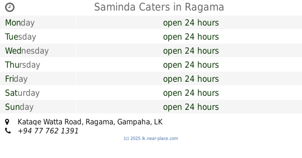
Saminda Caters
831/B, Katage Watta Road, Ragama
Food
read more
5.067 km
Co-op City Mahara
A1, Kadawatha
Food
read more
5.126 km
Deveni inima Juice Bar
Diyagala Boys Town Road, Ragama
Food
read more
5.263 km
Senevirathna Stores
Bollatha North, Ja-Ela
Food
read more
5.398 km
Pallet FOOD HOUSE
Ragama, 317/2 Pasal Mawatha, බටුවත්ත
Food
read more
📑
all categories
Accounting
Administrative area level 1
Administrative area level 2
Airport
Amusement park
Aquarium
Art gallery
Atm
Bakery
Bank
Bar
Beauty salon
Bicycle store
Book store
Bowling alley
Bus station
Cafe
Campground
Car dealer
Car rental
Car repair
Car wash
Casino
Cemetery
Church
City hall
Clothing store
Colloquial area
Convenience store
Country
Courthouse
Dentist
Department store
Doctor
Electrician
Electronics store
Embassy
Finance
Fire station
Florist
Food
Funeral home
Furniture store
Gas station
General contractor
Grocery or supermarket
Gym
Hair care
Hardware store
Health
Hindu Temple
Home goods store
Hospital
Insurance agency
Intersection
Jewelry store
Laundry
Lawyer
Library
Light rail station
Liquor store
Local government office
Locality
Locksmith
Lodging
Meal delivery
Meal takeaway
Mosque
Movie rental
Movie theater
Moving company
Museum
Natural feature
Neighborhood
Night club
Painter
Park
Parking
Pet store
Pharmacy
Physiotherapist
Place of worship
Plumber
Point of interest
Police
Political
Post office
Premise
Real estate agency
Restaurant
Roofing contractor
Route
Rv park, camping
School
Shoe store
Shopping mall
Spa
Stadium
Storage
Store
Subpremise
Supermarket
Synagogue
Taxi stand
Train station
Transit station
Travel agency
University
Veterinary care
Zoo
administrative area level 3
sublocality level 1
sublocality level 2
↑