Food nearby Sogama Estate ,
Coronavirus disease (COVID-19) Situation
confirmed cases
672754
deaths
16897
Sri Lanka
Food nearby Sogama Estate ,
Sogama Estate ,
Pussellawa Sri Lanka
contacts phone
:
+94
Latitude:
7.1196508
, Longitude:
80.6291247
read more
nearest Food
1.037 km
Rhinland Tea Factory
Nawakadadora, Udapalatha
Food
read more
1.623 km
H.A.R STORES
Pussellawa
Food
read more
2.981 km
New Peacock Estate
Udapalatha
Food
read more
3.97 km
Upali Stores
Galaha - Pupuressa Road, Pupuressa
Food
read more
4.125 km
Pupuressa Tea Factory
Pupuressa
Food
read more
4.485 km
Maligakanda Tea Factory
Galatha Road, Udapalatha
Food
read more
4.541 km
Delta Tea Factory
Pupuressa
Food
read more
4.673 km
Nayapana Estate maneger Bangalow
Udapalatha
Food
read more
4.96 km
Castle Milk Tea Factory
Food
read more
4.986 km
Sarasi Bakery
Pupuressa
Food
read more
5.162 km
Nayapane Estate Tea Factory
Udapalatha
Food
read more
6.461 km
Helbodde Tea Factory
Sri Lanka
Food
read more
8.446 km
Cool Park Cafe & Juice Bar
211A Ambagamuwa Road, Gampola
Food
read more
8.678 km
ZamZam Dairy Products
238/C, illangawatta, Kahatapitiya, Gampola
Food
read more
9.929 km
Tilton tea factory
Pallegama
Food
read more
10.418 km
Glenloch Tea Factory
Ramboda New Tunnel Road, Ramboda
Food
read more
10.632 km
Donside Tea Factory
Nawalapitiya - Harangala Road
Food
read more
11.123 km
Jinnah Bazzar Gelioya
Gelioya
Food
read more
11.41 km
Blue Field Tea Factory
Ramboda, Nuwara Eliya
Food
read more
12.439 km
Amma's Sujanith Food Products
Baily Road, Nawalapitiya
Food
read more
12.694 km
Fernlands Estate
Pundaluoya
Food
read more
12.708 km
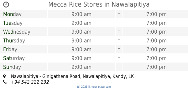
Mecca Rice Stores
Nawalapitiya - Ginigathena Road, Nawalapitiya
Food
read more
12.894 km
Madagoda Tea Factory
Gangaihala Korale
Food
read more
16.07 km
SHA Catering
kudaoya labukelle, A5
Food
read more
18.353 km
Galboda tea factory
Galboda
Food
read more
📑
all categories
Accounting
Administrative area level 1
Administrative area level 2
Airport
Amusement park
Aquarium
Art gallery
Atm
Bakery
Bank
Bar
Beauty salon
Bicycle store
Book store
Bowling alley
Bus station
Cafe
Campground
Car dealer
Car rental
Car repair
Car wash
Casino
Cemetery
Church
City hall
Clothing store
Colloquial area
Convenience store
Country
Courthouse
Dentist
Department store
Doctor
Electrician
Electronics store
Embassy
Finance
Fire station
Florist
Food
Funeral home
Furniture store
Gas station
General contractor
Grocery or supermarket
Gym
Hair care
Hardware store
Health
Hindu Temple
Home goods store
Hospital
Insurance agency
Intersection
Jewelry store
Laundry
Lawyer
Library
Light rail station
Liquor store
Local government office
Locality
Locksmith
Lodging
Meal delivery
Meal takeaway
Mosque
Movie rental
Movie theater
Moving company
Museum
Natural feature
Neighborhood
Night club
Painter
Park
Parking
Pet store
Pharmacy
Physiotherapist
Place of worship
Plumber
Point of interest
Police
Political
Post office
Premise
Real estate agency
Restaurant
Roofing contractor
Route
Rv park, camping
School
Shoe store
Shopping mall
Spa
Stadium
Storage
Store
Subpremise
Supermarket
Synagogue
Taxi stand
Train station
Transit station
Travel agency
University
Veterinary care
Zoo
administrative area level 3
sublocality level 1
sublocality level 2
↑