Food nearby Thalayadi Fishing Harbor
Coronavirus disease (COVID-19) Situation
confirmed cases
672754
deaths
16897
Sri Lanka
Food nearby Thalayadi Fishing Harbor
Thalayadi Fishing Harbor
Karainagar Sri Lanka
contacts phone
:
+94
Latitude:
9.7610425
, Longitude:
79.8778541
read more
nearest Food
7.779 km
Sathiyakattu Santhai Fish Market
Chulipuram East
Food
read more
8.467 km
Sri Murugan Stores
Vaddukkoddai-Moolai Road, Moolai
Food
read more
8.467 km
Sri Murugan Stores
Vaddukkodai-Moolai Road, Moolai
Food
read more
8.757 km
kalpana stores
Vaddukkoddai-Moolai Road, Moolai
Food
read more
9.941 km
New Agro Center
Vallai-Tellippalai-Araly Road, Pandatharippu
Food
read more
10.141 km
New Fish Market Chankanai
Food
read more
15.87 km
Appan Grinding Mill
அம்பலவாணர் வீதி, Chunnakam
Food
read more
15.892 km
Sri Nagathambiran Grinding Mill
Ambalavanar Road, Uduvil
Food
read more
16.334 km
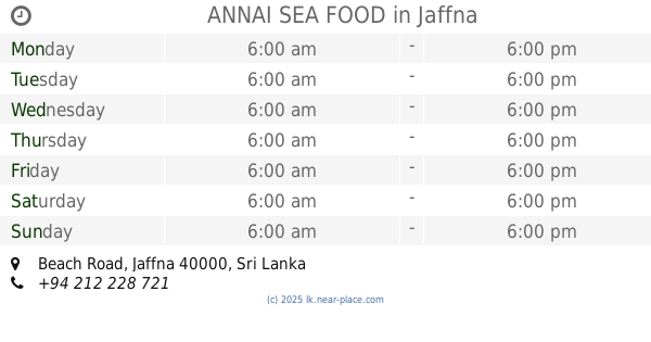
ANNAI SEA FOOD
Beach Road, Jaffna
Food
read more
17.474 km
American water
Jaffna
Food
read more
17.662 km
Pillaijar Mill
Jaffna
Food
read more
17.695 km
New Theensuvai Mixture
No 238, Jaffna-Kankesanturai Road, Kokkuvil
Food
read more
17.719 km
Sri Sivaram Traders
No.248, Hospital Road, 021-2228629, Jaffna
Food
read more
17.762 km
R.Sivslingam Fruits Centre
C Ponnampalam Road, Jaffna
Food
read more
17.848 km
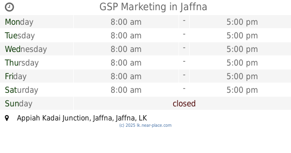
GSP Marketing
Appiah Kadai Junction, Jaffna
Food
read more
17.911 km
Anna Kopi
Jaffna
Food
read more
17.964 km
Jayam Cool Bar
No.133, Jaffna
Food
read more
18.123 km
Perumal-Yarlco
Jaffna
Food
read more
18.888 km
Selvan Stores & Veg Market
Jaffna
Food
read more
19.092 km
Reclamation Ice Factory
Jaffna
Food
read more
19.253 km
Omkara Stores
No. 06, Rakka Road, Jaffna
Food
read more
20.55 km
Seafood Exporters
Jaffna
Food
read more
20.872 km
COOLMAN ICE FACTORY
Sri Lanka
Food
read more
21.23 km
Sharon sea food exporters
62,Vithanes lane, Jaffna
Food
read more
21.892 km
Myliddy fisheries habour
Sri Lanka
Food
read more
📑
all categories
Accounting
Administrative area level 1
Administrative area level 2
Airport
Amusement park
Aquarium
Art gallery
Atm
Bakery
Bank
Bar
Beauty salon
Bicycle store
Book store
Bowling alley
Bus station
Cafe
Campground
Car dealer
Car rental
Car repair
Car wash
Casino
Cemetery
Church
City hall
Clothing store
Colloquial area
Convenience store
Country
Courthouse
Dentist
Department store
Doctor
Electrician
Electronics store
Embassy
Finance
Fire station
Florist
Food
Funeral home
Furniture store
Gas station
General contractor
Grocery or supermarket
Gym
Hair care
Hardware store
Health
Hindu Temple
Home goods store
Hospital
Insurance agency
Intersection
Jewelry store
Laundry
Lawyer
Library
Light rail station
Liquor store
Local government office
Locality
Locksmith
Lodging
Meal delivery
Meal takeaway
Mosque
Movie rental
Movie theater
Moving company
Museum
Natural feature
Neighborhood
Night club
Painter
Park
Parking
Pet store
Pharmacy
Physiotherapist
Place of worship
Plumber
Point of interest
Police
Political
Post office
Premise
Real estate agency
Restaurant
Roofing contractor
Route
Rv park, camping
School
Shoe store
Shopping mall
Spa
Stadium
Storage
Store
Subpremise
Supermarket
Synagogue
Taxi stand
Train station
Transit station
Travel agency
University
Veterinary care
Zoo
administrative area level 3
sublocality level 1
sublocality level 2
↑