Gas station nearby Ekala
Coronavirus disease (COVID-19) Situation
confirmed cases
672754
deaths
16897
Sri Lanka
Gas station nearby Ekala
Ekala
A33, Ja-Ela, Gampaha, LK Sri Lanka
contacts phone
:
+94
Latitude:
7.1007894
, Longitude:
79.912886
larger map & directions
read more
nearest Gas station
31 m
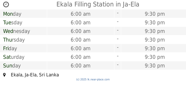
Ekala Filling Station
Ja-Ela
Gas station
read more
1.45 km
Chathuranga Motors
Ganemulla-JaEla Road, Ja-Ela
Gas station
read more
2.199 km
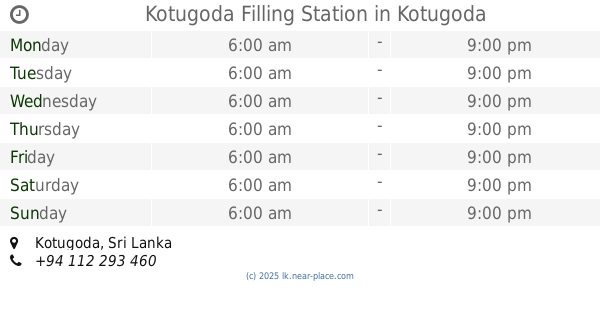
Kotugoda Filling Station
Kotugoda
Gas station
read more
2.388 km
Kumara's Garage
Ja-Ela
Gas station
read more
2.835 km
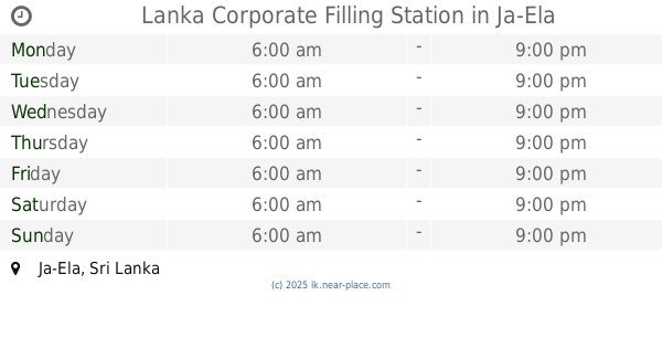
Lanka Corporate Filling Station
Ja-Ela
Gas station
read more
2.892 km
Lanka IOC Filling Station
Ja-Ela
Gas station
read more
3.055 km
Dandugama Fuel Station
Dandugama
Gas station
read more
3.186 km
Alliance enterprises
Dandugama
Gas station
read more
3.209 km
Ceypetco Gas Station
A3, Dandugama
Gas station
read more
3.566 km
WSS Auto Fuels Filling Station
11350, 143 Negombo-Colombo Main Road, Ja-Ela
Gas station
read more
3.779 km
CPC Gas Station
Peliyagoda-Puttalam Highway, Ja-Ela
Gas station
read more
3.784 km
Ceypetco Fuel Station
Gampaha
Gas station
read more
3.877 km
Lithro Gas Shop
Ja-ela - Ganemulla Road, Ja-Ela
Gas station
read more
4.067 km
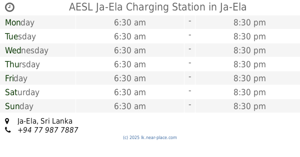
AESL Ja-Ela Charging Station
Ja-Ela
Gas station
read more
4.09 km
Ev Charging Weligampitiya Ja-Ela
Ja-Ela
Gas station
read more
4.431 km
Bandarawatta Fuel Station
Seeduwa
Gas station
read more
4.464 km
Laugfs Auto Gas Filling Station
Chilaw - Colombo Main Road, Seeduwa
Gas station
read more
4.55 km
Ceypetco Fuel Station
Ja-Ela
Gas station
read more
4.964 km
Litro Gas Shop
Cemetery Road, Ja-Ela
Gas station
read more
4.964 km
Litro Gas Shop
Cemetery Rd, Ja-Ela
Gas station
read more
11.303 km
Kirillawala Filling Station
Gas station
read more
12.585 km
Jayasooriya Filling Station
Negombo-Colombo Main Road, Wattala
Gas station
read more
12.634 km
Ceypetco Fuel Station
Negombo
Gas station
read more
14.577 km
Ceypetco
Negombo
Gas station
read more
17.236 km
Nawa Lanka Sewa Filing Station
Janadhipathi Mawatha, Colombo
Gas station
read more
📑
all categories
Accounting
Administrative area level 1
Administrative area level 2
Airport
Amusement park
Aquarium
Art gallery
Atm
Bakery
Bank
Bar
Beauty salon
Bicycle store
Book store
Bowling alley
Bus station
Cafe
Campground
Car dealer
Car rental
Car repair
Car wash
Casino
Cemetery
Church
City hall
Clothing store
Colloquial area
Convenience store
Country
Courthouse
Dentist
Department store
Doctor
Electrician
Electronics store
Embassy
Finance
Fire station
Florist
Food
Funeral home
Furniture store
Gas station
General contractor
Grocery or supermarket
Gym
Hair care
Hardware store
Health
Hindu Temple
Home goods store
Hospital
Insurance agency
Intersection
Jewelry store
Laundry
Lawyer
Library
Light rail station
Liquor store
Local government office
Locality
Locksmith
Lodging
Meal delivery
Meal takeaway
Mosque
Movie rental
Movie theater
Moving company
Museum
Natural feature
Neighborhood
Night club
Painter
Park
Parking
Pet store
Pharmacy
Physiotherapist
Place of worship
Plumber
Point of interest
Police
Political
Post office
Premise
Real estate agency
Restaurant
Roofing contractor
Route
Rv park, camping
School
Shoe store
Shopping mall
Spa
Stadium
Storage
Store
Subpremise
Supermarket
Synagogue
Taxi stand
Train station
Transit station
Travel agency
University
Veterinary care
Zoo
administrative area level 3
sublocality level 1
sublocality level 2
↑