Gym nearby Master Gym
Coronavirus disease (COVID-19) Situation
confirmed cases
672754
deaths
16897
Sri Lanka
Gym nearby Master Gym
Master Gym
Bentota, Sri Lanka
contacts phone
:
+94
Latitude:
6.4189662
, Longitude:
80.0163352
larger map & directions
read more
nearest Gym
2.045 km
Shaan Gym
Aluthgama
Gym
read more
2.233 km
Gold Gym
A2, Aluthgama
Gym
read more
2.575 km
Smart Fitness Center
Dharga Town
Gym
read more
2.846 km
Young Mans Sports Club
Jeelani Road Dharga Town
Gym
read more
2.99 km
United Sports Club
Zahira College Road, Dharga Town
Gym
read more
7.852 km
walagedara volleyball court
Walagedara
Gym
read more
14.898 km
Dodangoda Public Ground
Dodangoda, Kalutara
Gym
read more
16.057 km
Xtream Fitness
Matugama
Gym
read more
16.343 km
SF GYMNASIUM
Kalutara-Matugama Road, Kalutara
Gym
read more
18.953 km
Dimuthu fitness Center
B304, Matugama
Gym
read more
19.455 km
KTC Gym and Fitness Center
Station Road, Kalutara
Gym
read more
19.641 km
Sana Fitness Center
37, OLD Road, Kalutara South, Kalutara
Gym
read more
19.976 km
STS Gym
Ambalangoda - Batapola Road, Ambalangoda
Gym
read more
20.25 km
Egal Fitness Centre
Sri Lanka
Gym
read more
20.25 km
Egal Fitness Centre
Thekkawatta
Gym
read more
20.471 km
Southern Fitness and Health Care Center
No 9 Wickramasuriya Road, Ambalangoda
Gym
read more
20.509 km
VNV Life Fitness World
422 Colombo - Galle Main Road, Kalutara
Gym
read more
21.581 km
The Gym Physical Fitness Academy
Elpitiya
Gym
read more
22.062 km
Dasun's Gym
Sri Lanka
Gym
read more
22.249 km
MA Fitness Center
Pelawatta
Gym
read more
24.799 km
Diyawanna Walkway
No 1
Gym
read more
25.096 km
Suhada Sports Club Nugagoda
Panapitiya Road, Wadduwa
Gym
read more
47.46 km
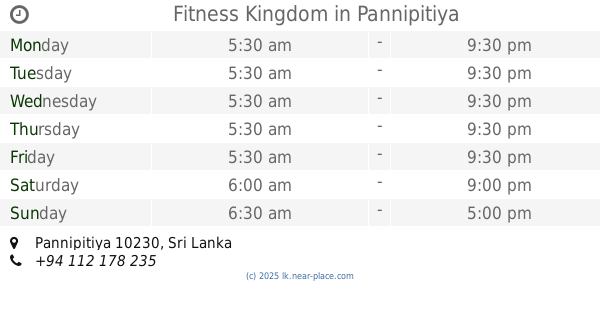
Fitness Kingdom
Pannipitiya
Gym
read more
50.316 km
PRAN FITNESS
550/2 Old Kottawa Road, Nugegoda
Gym
read more
57.15 km
Golden Galle Gym
Habaraduwa
Gym
read more
📑
all categories
Accounting
Administrative area level 1
Administrative area level 2
Airport
Amusement park
Aquarium
Art gallery
Atm
Bakery
Bank
Bar
Beauty salon
Bicycle store
Book store
Bowling alley
Bus station
Cafe
Campground
Car dealer
Car rental
Car repair
Car wash
Casino
Cemetery
Church
City hall
Clothing store
Colloquial area
Convenience store
Country
Courthouse
Dentist
Department store
Doctor
Electrician
Electronics store
Embassy
Finance
Fire station
Florist
Food
Funeral home
Furniture store
Gas station
General contractor
Grocery or supermarket
Gym
Hair care
Hardware store
Health
Hindu Temple
Home goods store
Hospital
Insurance agency
Intersection
Jewelry store
Laundry
Lawyer
Library
Light rail station
Liquor store
Local government office
Locality
Locksmith
Lodging
Meal delivery
Meal takeaway
Mosque
Movie rental
Movie theater
Moving company
Museum
Natural feature
Neighborhood
Night club
Painter
Park
Parking
Pet store
Pharmacy
Physiotherapist
Place of worship
Plumber
Point of interest
Police
Political
Post office
Premise
Real estate agency
Restaurant
Roofing contractor
Route
Rv park, camping
School
Shoe store
Shopping mall
Spa
Stadium
Storage
Store
Subpremise
Supermarket
Synagogue
Taxi stand
Train station
Transit station
Travel agency
University
Veterinary care
Zoo
administrative area level 3
sublocality level 1
sublocality level 2
↑