Gym nearby ULTRA GYM Kirindiwela
Coronavirus disease (COVID-19) Situation
confirmed cases
672754
deaths
16897
Sri Lanka
Gym nearby ULTRA GYM Kirindiwela
ULTRA GYM Kirindiwela
Kirindiwela, Sri Lanka
contacts phone
:
+94
Latitude:
7.0422328
, Longitude:
80.128803
larger map & directions
read more
nearest Gym
267 m
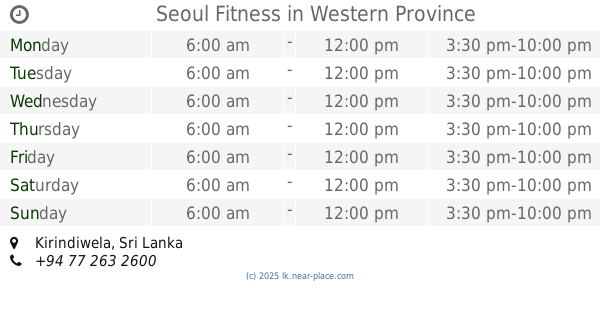
Seoul Fitness
Kirindiwela
Gym
read more
310 m
Eksath Sport Club
Eksath sport club kirindewela
Gym
read more
4.563 km
Body Force Jym
Delgoda - Kirindiwela Road, Palahala
Gym
read more
5.158 km
Damro public service Academy Urapola
Gampaha
Gym
read more
5.974 km
M.M.A club
Kurawalana
Gym
read more
9.458 km
District Level Sports Complex
Wathupitiwala
Gym
read more
10.444 km
Sha Fitness Center
Nittambuwa
Gym
read more
11.534 km
Supreme Fitness
A1, Gampaha
Gym
read more
11.603 km
Elite Fitness
Salawa
Gym
read more
11.605 km
Fitness 360
New Kandy Road, Weliweriya
Gym
read more
11.617 km
Chepy Gym
A1, Nittambuwa
Gym
read more
12.95 km
Mega Power GYM
Gampaha
Gym
read more
13.147 km
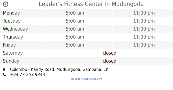
Leader's Fitness Center
No 80/2/6, Colombo - Kandy Road, Mudungoda
Gym
read more
13.938 km
Future Fitness
7, 9/A Yakkala Road, Gampaha
Gym
read more
14.662 km
Metalica Gym
AB29, Gampaha
Gym
read more
14.746 km
Karawanelle City
Kegalle
Gym
read more
15.008 km
Smart Gym
Bemmulla
Gym
read more
15.404 km
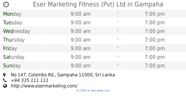
Eser Marketing Fitness (Pvt) Ltd
No 147, Colombo Rd,, Gampaha
Gym
read more
15.725 km
Sahassa Gym
135 New Kandy Road
Gym
read more
15.782 km
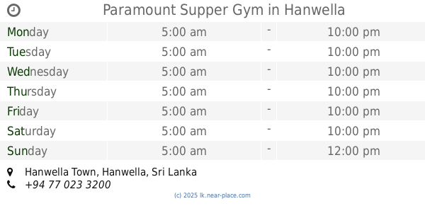
Paramount Supper Gym
Hanwella Town, Hanwella
Gym
read more
15.858 km
Fitnes Center
Sapugaskanda Oil Refinery Junction - Biyagama Free Trade Zone Road
Gym
read more
16.89 km
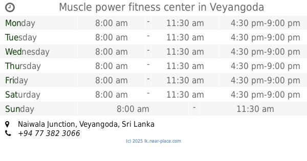
Muscle power fitness center
Naiwala Junction, Veyangoda
Gym
read more
17.251 km
Aerobics Exercise &, Punsara Fitness Siyambalape
539 New Kandy Road
Gym
read more
17.253 km
Punsara Fitness
539, New Kandy Road, කඩුවෙල
Gym
read more
19.56 km
Fahalalawela Cricket Ground
B174
Gym
read more
📑
all categories
Accounting
Administrative area level 1
Administrative area level 2
Airport
Amusement park
Aquarium
Art gallery
Atm
Bakery
Bank
Bar
Beauty salon
Bicycle store
Book store
Bowling alley
Bus station
Cafe
Campground
Car dealer
Car rental
Car repair
Car wash
Casino
Cemetery
Church
City hall
Clothing store
Colloquial area
Convenience store
Country
Courthouse
Dentist
Department store
Doctor
Electrician
Electronics store
Embassy
Finance
Fire station
Florist
Food
Funeral home
Furniture store
Gas station
General contractor
Grocery or supermarket
Gym
Hair care
Hardware store
Health
Hindu Temple
Home goods store
Hospital
Insurance agency
Intersection
Jewelry store
Laundry
Lawyer
Library
Light rail station
Liquor store
Local government office
Locality
Locksmith
Lodging
Meal delivery
Meal takeaway
Mosque
Movie rental
Movie theater
Moving company
Museum
Natural feature
Neighborhood
Night club
Painter
Park
Parking
Pet store
Pharmacy
Physiotherapist
Place of worship
Plumber
Point of interest
Police
Political
Post office
Premise
Real estate agency
Restaurant
Roofing contractor
Route
Rv park, camping
School
Shoe store
Shopping mall
Spa
Stadium
Storage
Store
Subpremise
Supermarket
Synagogue
Taxi stand
Train station
Transit station
Travel agency
University
Veterinary care
Zoo
administrative area level 3
sublocality level 1
sublocality level 2
↑