Hospital nearby Co-Op Channel centre
Coronavirus disease (COVID-19) Situation
confirmed cases
672754
deaths
16897
Sri Lanka
Hospital nearby Co-Op Channel centre
Co-Op Channel centre
Matale, Sri Lanka
contacts phone
:
+94 662 222 400
Latitude:
7.4669872
, Longitude:
80.623923
larger map & directions
read more
nearest Hospital
77 m
madawala medical Center
a 9 road, මඩවල උල්පත, mathale
Hospital
read more
126 m
Royal Pharmacy
Kings Street, Matale
Hospital
read more
132 m
Janananda ayuruveda shop
No 47, Main Street Kandy - Jaffna Highway, Matale
Hospital
read more
139 m
Janananda ayuruvedic shop
No 47, Kandy-Jaffna Highway, Matale
Hospital
read more
318 m
Matale Nursing Home
Matale
Hospital
read more
331 m
Dimuthu Channeling Service
Matale
Hospital
read more
348 m
Kumudu Hospital
48, Kandy-Jaffna Highway, Matale
Hospital
read more
380 m
Bas Hospital Matale
Kandy-Jaffna Highway, Matale
Hospital
read more
436 m
Medicare Clinic
Matale
Hospital
read more
557 m
Wazir (pvt)ltd. Suwa Niwasa Channeling Centre
Kings Street, Matale
Hospital
read more
661 m
District General Hospital Matale
Matale
Hospital
read more
715 m
Health Services Office
Matale
Hospital
read more
811 m
Matale Medical Center
Matale
Hospital
read more
986 m
Government Homeopathi Clinic
Muhandiram, Matale
Hospital
read more
1.095 km
Kandy Hospetal
Matale
Hospital
read more
2.781 km
Ayurvedic Hospital - Tenna
Matale-Udupihilla Road, Matale
Hospital
read more
2.818 km
Medical Center Dr Samantha Dissanayake
Tenna road
Hospital
read more
3.994 km
Praveen Patient Care Center
A9, Kandy
Hospital
read more
4.085 km
Divisional Hospital - Ovilikanda
Sri Lanka
Hospital
read more
4.093 km
Aluviharaya hospital
Matale Road, Matale
Hospital
read more
4.604 km
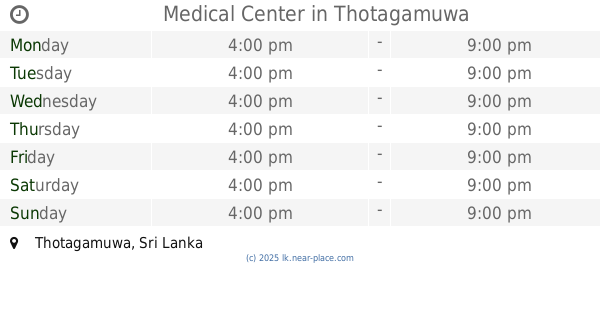
Medical Center
Thotagamuwa
Hospital
read more
4.881 km
Dr Nirosha's Medical Centre
Matale
Hospital
read more
4.96 km
IAS HOSPITAL
Thotagamuwa
Hospital
read more
5.88 km
Primary Medical Care Unit
Matale
Hospital
read more
6.622 km
Ankumbura Divisional Hospital
Alawatugoda-Ankumbura-Keppetigala Road, Ankumbura
Hospital
read more
📑
all categories
Accounting
Administrative area level 1
Administrative area level 2
Airport
Amusement park
Aquarium
Art gallery
Atm
Bakery
Bank
Bar
Beauty salon
Bicycle store
Book store
Bowling alley
Bus station
Cafe
Campground
Car dealer
Car rental
Car repair
Car wash
Casino
Cemetery
Church
City hall
Clothing store
Colloquial area
Convenience store
Country
Courthouse
Dentist
Department store
Doctor
Electrician
Electronics store
Embassy
Finance
Fire station
Florist
Food
Funeral home
Furniture store
Gas station
General contractor
Grocery or supermarket
Gym
Hair care
Hardware store
Health
Hindu Temple
Home goods store
Hospital
Insurance agency
Intersection
Jewelry store
Laundry
Lawyer
Library
Light rail station
Liquor store
Local government office
Locality
Locksmith
Lodging
Meal delivery
Meal takeaway
Mosque
Movie rental
Movie theater
Moving company
Museum
Natural feature
Neighborhood
Night club
Painter
Park
Parking
Pet store
Pharmacy
Physiotherapist
Place of worship
Plumber
Point of interest
Police
Political
Post office
Premise
Real estate agency
Restaurant
Roofing contractor
Route
Rv park, camping
School
Shoe store
Shopping mall
Spa
Stadium
Storage
Store
Subpremise
Supermarket
Synagogue
Taxi stand
Train station
Transit station
Travel agency
University
Veterinary care
Zoo
administrative area level 3
sublocality level 1
sublocality level 2
↑