Library nearby Thabbowa Community Hall & Library
Coronavirus disease (COVID-19) Situation
confirmed cases
672754
deaths
16897
Sri Lanka
Library nearby Thabbowa Community Hall & Library
Thabbowa Community Hall & Library
Thabbowa Sri Lanka
contacts phone
:
+94
Latitude:
8.0731984
, Longitude:
79.9239912
read more
nearest Library
4.465 km
Karuwalagaswewa Public Library
Karuwalagaswewa-Miyallewa Road, Karuwalagaswewa
Library
read more
11.277 km
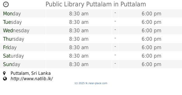
Public Library Puttalam
Puttalam
Library
read more
11.285 km
Puttalam Public Library
Puttalam
Library
read more
11.757 km
Puttalam Public Library
Lake Shore Street
Library
read more
15.993 km
Public Library
Erukkalampiddy
Library
read more
21.555 km
Public Library
Etalai
Library
read more
23.123 km
Public Library
Puttalam Road, Saliyawewa
Library
read more
23.495 km
Pallivasalthurai Public Library
Puttalam
Library
read more
24.023 km
Kanamoolai Library
Madurankuli
Library
read more
24.328 km
Kanamoolai School Library
Library
read more
25.189 km
Sameeragama Public Library
Sri Lanka
Library
read more
25.781 km
Public Library
Perakumpura
Library
read more
28.278 km
Kottantivu Public Library
Puttalam
Library
read more
29.976 km
Public Library
Pahala Giribawa
Library
read more
31.273 km
Mundel Public Library
Puttalam
Library
read more
32.9 km
Rupawahini Muthuhara Library
Andigama
Library
read more
34.545 km
Library Rajanjanaya
Rajanganaya Road, Rajanganaya
Library
read more
38.68 km
Model Library
Anamaduwa Road, Galgamuwa
Library
read more
39.113 km
Galgamuwa
Upper Road, Galgamuwa
Library
read more
39.213 km
Ambanpola Public Library
Ambanpola
Library
read more
40.276 km
Pottukkulama Library
B45
Library
read more
41.551 km
Public Library
Nikaweratiya-Maho Road, Nikaweratiya
Library
read more
47.626 km
Public Library Maho
Maho
Library
read more
47.64 km
Public Library
Nikaweratiya - Moragollagama - Siyambalangamuwa, Maho
Library
read more
60.855 km
Thalamalgama Public Library
Hiriyala Station Road
Library
read more
📑
all categories
Accounting
Administrative area level 1
Administrative area level 2
Airport
Amusement park
Aquarium
Art gallery
Atm
Bakery
Bank
Bar
Beauty salon
Bicycle store
Book store
Bowling alley
Bus station
Cafe
Campground
Car dealer
Car rental
Car repair
Car wash
Casino
Cemetery
Church
City hall
Clothing store
Colloquial area
Convenience store
Country
Courthouse
Dentist
Department store
Doctor
Electrician
Electronics store
Embassy
Finance
Fire station
Florist
Food
Funeral home
Furniture store
Gas station
General contractor
Grocery or supermarket
Gym
Hair care
Hardware store
Health
Hindu Temple
Home goods store
Hospital
Insurance agency
Intersection
Jewelry store
Laundry
Lawyer
Library
Light rail station
Liquor store
Local government office
Locality
Locksmith
Lodging
Meal delivery
Meal takeaway
Mosque
Movie rental
Movie theater
Moving company
Museum
Natural feature
Neighborhood
Night club
Painter
Park
Parking
Pet store
Pharmacy
Physiotherapist
Place of worship
Plumber
Point of interest
Police
Political
Post office
Premise
Real estate agency
Restaurant
Roofing contractor
Route
Rv park, camping
School
Shoe store
Shopping mall
Spa
Stadium
Storage
Store
Subpremise
Supermarket
Synagogue
Taxi stand
Train station
Transit station
Travel agency
University
Veterinary care
Zoo
administrative area level 3
sublocality level 1
sublocality level 2
↑