Lodging nearby Hotel Randiya රන්දිය හොටෙල්
Sri Lanka
Lodging nearby Hotel Randiya රන්දිය හොටෙල්
Hotel Randiya රන්දිය හොටෙල්
Mawanella, Sri Lanka
contacts phone
:
+94
Latitude:
7.2476427
, Longitude:
80.4439954
larger map & directions
read more
nearest Lodging
288 m
Pathu Catering Shop
Mawanella
Lodging
read more
312 m
Hotel Ameshi
No 122 ,Aranayake Rd , Mawanella, Mawanella-Aranayake-Horawela Road, Mawanella
Lodging
read more
434 m
The Curry Pot
Gampola-Craighead Road, Mawanella
Lodging
read more
600 m
Paris Hotel & Bake House
Lodging
read more
600 m
Paris Hotel & Bake House
Sri Lanka
Lodging
read more
600 m
Paris Hotel & Bake House
65 A1, Mawanella
Lodging
read more
604 m
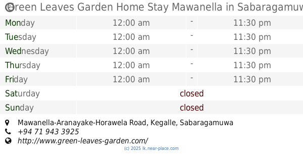
Green Leaves Garden Home Stay Mawanella
Mawanella-Aranayake-Horawela Road
Lodging
read more
702 m
Nana Kade
Nayawela, Mawanella
Lodging
read more
714 m
Hotel Maa Uyana මා උයන හොටෙල්
Aranayaka, Mawanella-Aranayake-Horawela Road
Lodging
read more
748 m
Highway Night Hotel
Sri Lanka
Lodging
read more
779 m
Ajmeer Hotel 1
Mawanella
Lodging
read more
838 m
Grand Palace
Mawanella
Lodging
read more
901 m
Muzammil's Manzil
Nayawela Road, Mawanella
Lodging
read more
936 m
MAKEN GARDEN - 276 / 6
276/6, MAKEN GARDEN, Kottawatha, Mawanella - Hemmaththagama - Singhapitiya, Mawanella
Lodging
read more
1.306 km
Ayesha Wel Eliya Reception Hall
Kegalle
Lodging
read more
1.342 km
Shafeek Haneefa
197/27,Rambukkana Road,waralliyadda,Mahawatta, Mawanella
Lodging
read more
1.42 km
Hostel ZCM
Zahira Road, Mawanella
Lodging
read more
1.566 km
Hotel Dewmini
Mawanella
Lodging
read more
1.745 km
Mount Heaven Resort
Colombo - Kandy Road, Uthuwankanda
Lodging
read more
1.805 km
Ancient Gardens
Owatta, Mawanella
Lodging
read more
1.868 km
Golden Gate Hotel
Mawanella
Lodging
read more
2.037 km
Palace of Nusry
Kegalle
Lodging
read more
2.119 km
Keenlee Youth Hostel
Colombo-Kandy Highway 365, Dewaragampola
Lodging
read more
2.258 km
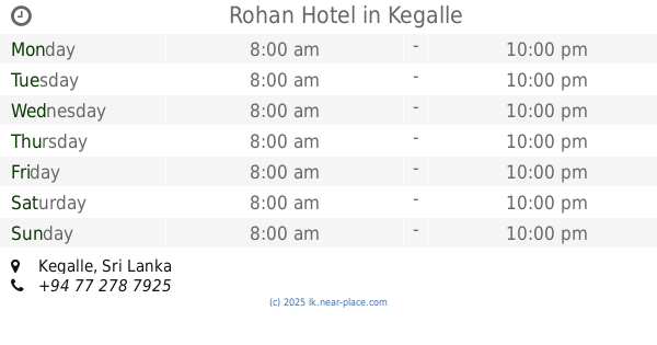
Rohan Hotel
Kegalle
Lodging
read more
2.844 km
Hingula Resort
Ganethanna - Owatta Road, Hingula
Lodging
read more
📑
all categories
Accounting
Administrative area level 1
Administrative area level 2
Airport
Amusement park
Aquarium
Art gallery
Atm
Bakery
Bank
Bar
Beauty salon
Bicycle store
Book store
Bowling alley
Bus station
Cafe
Campground
Car dealer
Car rental
Car repair
Car wash
Casino
Cemetery
Church
City hall
Clothing store
Colloquial area
Convenience store
Country
Courthouse
Dentist
Department store
Doctor
Electrician
Electronics store
Embassy
Finance
Fire station
Florist
Food
Funeral home
Furniture store
Gas station
General contractor
Grocery or supermarket
Gym
Hair care
Hardware store
Health
Hindu Temple
Home goods store
Hospital
Insurance agency
Intersection
Jewelry store
Laundry
Lawyer
Library
Light rail station
Liquor store
Local government office
Locality
Locksmith
Lodging
Meal delivery
Meal takeaway
Mosque
Movie rental
Movie theater
Moving company
Museum
Natural feature
Neighborhood
Night club
Painter
Park
Parking
Pet store
Pharmacy
Physiotherapist
Place of worship
Plumber
Point of interest
Police
Political
Post office
Premise
Real estate agency
Restaurant
Roofing contractor
Route
Rv park, camping
School
Shoe store
Shopping mall
Spa
Stadium
Storage
Store
Subpremise
Supermarket
Synagogue
Taxi stand
Train station
Transit station
Travel agency
University
Veterinary care
Zoo
administrative area level 3
sublocality level 1
sublocality level 2
↑