Park nearby BMU Land
Coronavirus disease (COVID-19) Situation
confirmed cases
672754
deaths
16897
Sri Lanka
Park nearby BMU Land
BMU Land
Ethulgama Upper Zone, Thalathuoya, Sri Lanka
contacts phone
:
+94 71 424 2729
Latitude:
7.2421618
, Longitude:
80.6692912
larger map & directions
read more
nearest Park
1.789 km
Hanthana land
Sri Lanka
Park
read more
2.178 km
Ambalammana Mountain Peak
Pathahewaheta
Park
read more
3.735 km
Children's Park
Gurudeniya
Park
read more
3.948 km
Warg
Nattarampota
Park
read more
4.653 km
Children's Park
Park
read more
4.657 km
Sarath Ekanayake Children's Park
Kundasale
Park
read more
4.755 km
Hanthana Mountain
Upper Hanthana Road
Park
read more
4.956 km
Hanthana Holiday Rooms
13/B/15/1, Hanthana, Kandy
Park
read more
5.241 km
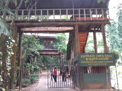
Dunumadalawa Forest Reserve
Kandy
Park
read more
5.262 km
Ayojanagama
Janasavigama
Park
read more
5.539 km
Research Medical Plants Garden Pallekele
Janasavigama
Park
read more
5.681 km
Mahamaya Garden
Bogambara Lake, Kandy
Park
read more
6.403 km
Wace Park / Royal Palace Park
Rajapihilla Mawatha, Kandy
Park
read more
6.521 km
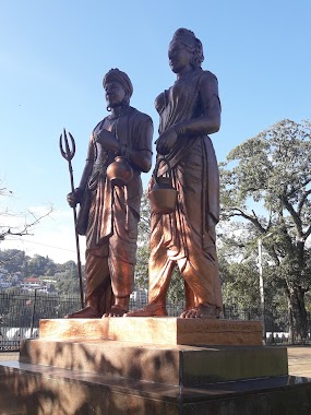
Saliya and Asokamala Memorial
Kandy
Park
read more
6.585 km
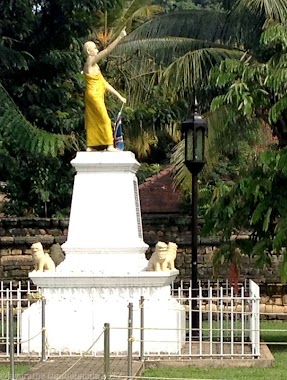
Sumangala Himi Memorial
Kandy
Park
read more
7.05 km
Dangolla Childrens Park
Kandy
Park
read more
7.623 km
Pallekele Grid Substation
Balagolla
Park
read more
8.143 km
ALA Garden
University of
Park
read more
8.25 km
Hitch Tree
University of, University of
Park
read more
9.418 km
Rosewood Garden
Kandy
Park
read more
9.577 km
New Ranweli Spice Garden 99
No.31,Muruthalawa Road,Gannoruwa
Park
read more
11.126 km
Pettigala, Kandy
Medadumbara
Park
read more
12.132 km
Children Park - Wattegama
Wattegama
Park
read more
14.277 km
Gonigoda Pump House
Gonigoda,Medawela
Park
read more
14.654 km
Surathura Spice & Herbal Garden
Udapalatha
Park
read more
📑
all categories
Accounting
Administrative area level 1
Administrative area level 2
Airport
Amusement park
Aquarium
Art gallery
Atm
Bakery
Bank
Bar
Beauty salon
Bicycle store
Book store
Bowling alley
Bus station
Cafe
Campground
Car dealer
Car rental
Car repair
Car wash
Casino
Cemetery
Church
City hall
Clothing store
Colloquial area
Convenience store
Country
Courthouse
Dentist
Department store
Doctor
Electrician
Electronics store
Embassy
Finance
Fire station
Florist
Food
Funeral home
Furniture store
Gas station
General contractor
Grocery or supermarket
Gym
Hair care
Hardware store
Health
Hindu Temple
Home goods store
Hospital
Insurance agency
Intersection
Jewelry store
Laundry
Lawyer
Library
Light rail station
Liquor store
Local government office
Locality
Locksmith
Lodging
Meal delivery
Meal takeaway
Mosque
Movie rental
Movie theater
Moving company
Museum
Natural feature
Neighborhood
Night club
Painter
Park
Parking
Pet store
Pharmacy
Physiotherapist
Place of worship
Plumber
Point of interest
Police
Political
Post office
Premise
Real estate agency
Restaurant
Roofing contractor
Route
Rv park, camping
School
Shoe store
Shopping mall
Spa
Stadium
Storage
Store
Subpremise
Supermarket
Synagogue
Taxi stand
Train station
Transit station
Travel agency
University
Veterinary care
Zoo
administrative area level 3
sublocality level 1
sublocality level 2
↑