Point of interest nearby Chemwood Exports (PVT)Ltd
Sri Lanka
Point of interest nearby Chemwood Exports (PVT)Ltd
Chemwood Exports (PVT)Ltd
6.849990, 80.042839, Sri Lanka
contacts phone
:
+94 112 857 010
website:
www.chemwood.net
Latitude:
6.84999
, Longitude:
80.042839
larger map & directions
read more
nearest Point of interest
350 m
Ceylone Barcode (Pvt)Ltd
Gehenuwala
Point of interest
read more
405 m
Unicorn CS
14f Nisala Garden, Jayaboo Mawatha
Point of interest
read more
592 m
Blue Nine Entertainment
107/5 Asiri Uyana,Puwakwatta Road, Meegoda 10504, Meegoda,Srilanka
Point of interest
read more
626 m
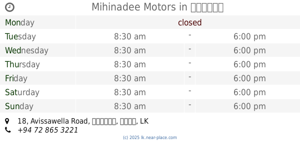
Mihinadee Motors
B, 18 Avissawella Road, හෝමාගම
Point of interest
read more
760 m
Green frontiers EV fast charging station - Godagama
"Solar Life Technologies", 5/2,High Level Rd, Godagama, Colombo - Batticaloa Highway, Godagama
Point of interest
read more
774 m
land to sale
Simon Peries Suriyapperuma Mawatha, Lionel Jayasinghe Mawatha, Godagama
Point of interest
read more
784 m
Meegoda Economic Center
B240
Point of interest
read more
802 m
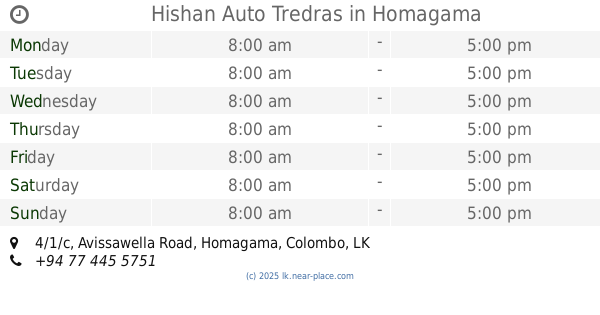
Hishan Auto Tredras
4/1/c Avissawella Road, Homagama
Point of interest
read more
861 m
Kumara Construction & Engineering Works
Meegoda Road
Point of interest
read more
866 m
Mayadunne Traders
B240
Point of interest
read more
908 m
Mahabodhi Child Development Center
Sirimedurawatte, Naduhena, Meegoda, Nawalamulla Road
Point of interest
read more
952 m
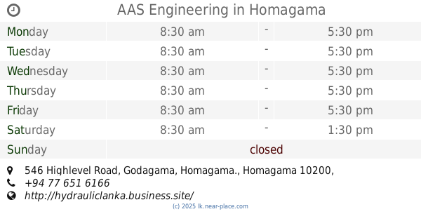
AAS Engineering
546 Highlevel Road, Godagama, Homagama., Homagama
Point of interest
read more
973 m
Hettiarachchi Industries - Cement Bricks Manufacturing Plant
Kurunduwatta, Colombo
Point of interest
read more
1.152 km
Nehara Stores
Daham Mawatha
Point of interest
read more
1.158 km
Print Win Offset Printing
Sri Lanka
Point of interest
read more
📑
all categories
Accounting
Administrative area level 1
Administrative area level 2
Airport
Amusement park
Aquarium
Art gallery
Atm
Bakery
Bank
Bar
Beauty salon
Bicycle store
Book store
Bowling alley
Bus station
Cafe
Campground
Car dealer
Car rental
Car repair
Car wash
Casino
Cemetery
Church
City hall
Clothing store
Colloquial area
Convenience store
Country
Courthouse
Dentist
Department store
Doctor
Electrician
Electronics store
Embassy
Finance
Fire station
Florist
Food
Funeral home
Furniture store
Gas station
General contractor
Grocery or supermarket
Gym
Hair care
Hardware store
Health
Hindu Temple
Home goods store
Hospital
Insurance agency
Intersection
Jewelry store
Laundry
Lawyer
Library
Light rail station
Liquor store
Local government office
Locality
Locksmith
Lodging
Meal delivery
Meal takeaway
Mosque
Movie rental
Movie theater
Moving company
Museum
Natural feature
Neighborhood
Night club
Painter
Park
Parking
Pet store
Pharmacy
Physiotherapist
Place of worship
Plumber
Point of interest
Police
Political
Post office
Premise
Real estate agency
Restaurant
Roofing contractor
Route
Rv park, camping
School
Shoe store
Shopping mall
Spa
Stadium
Storage
Store
Subpremise
Supermarket
Synagogue
Taxi stand
Train station
Transit station
Travel agency
University
Veterinary care
Zoo
administrative area level 3
sublocality level 1
sublocality level 2
↑