Restaurant nearby Atchuveli
Coronavirus disease (COVID-19) Situation
confirmed cases
672754
deaths
16897
Sri Lanka
Restaurant nearby Atchuveli
Atchuveli
Jaffna, Sri Lanka
contacts phone
:
+94
Latitude:
9.7708931
, Longitude:
80.1074484
larger map & directions
read more
nearest Restaurant
1.182 km
New Rahman Muslim Hotel
Main Street, Atchuvely, Jaffna
Restaurant
read more
9.355 km
Yutharshan Photos
North Alaveddy, Alaveddy
Restaurant
read more
9.945 km
Mister Jaffna Hotel
அம்பலவாணர் வீதி, Chunnakam
Restaurant
read more
10.343 km
Jafna Rest House Sls
Kondavil
Restaurant
read more
10.675 km
Everest Family Restaurant
Nelliady, Jaffna Rd, Karaveddi
Restaurant
read more
11.4 km
Nayki Products
Sri Lanka
Restaurant
read more
12.567 km
Jeevan
Jaffna
Restaurant
read more
12.609 km
நெய்தல் போசனசாலை (Neithal Hotel)
183 Aadiyapatham Road, Jaffna
Restaurant
read more
12.829 km
Sneha Restaurent
Brown Road, Kokuvil East
Restaurant
read more
13.297 km
VS Hotel
Jaffna
Restaurant
read more
13.385 km
Shakthi Hotel
Jaffna
Restaurant
read more
13.431 km
Yarl Fruits & Foods
Jaffna
Restaurant
read more
13.542 km
Chelva Restaurant
1229, AB16, Jaffna
Restaurant
read more
13.611 km
Mangos Indian Veg
359/3, Temple Road, Jaffna
Restaurant
read more
13.837 km
Royal Cream House
Kovil Road, Jaffna
Restaurant
read more
14.356 km
Danuska Restaurant
Jaffna
Restaurant
read more
14.988 km
st anns hotel
Jaffna
Restaurant
read more
15.095 km
Adina Restaurant
Columbuthurai Road, Jaffna
Restaurant
read more
15.198 km
Raaja Restauran
Point Pedro
Restaurant
read more
15.345 km
Akaran Restaurant
Point Pedro
Restaurant
read more
15.355 km
Kishoni Bakery
Point Pedro
Restaurant
read more
15.521 km
Lingan Ice Cream
213 Stanley road, යාපනය
Restaurant
read more
15.616 km
Vijaya Cool bar
bus stand, Jaffna
Restaurant
read more
15.682 km
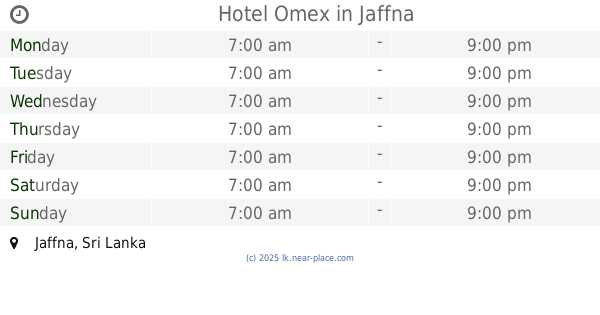
Hotel Omex
Jaffna
Restaurant
read more
16.004 km
Thaj Hotel
Kandy - Jaffna Hwy, Jaffna
Restaurant
read more
📑
all categories
Accounting
Administrative area level 1
Administrative area level 2
Airport
Amusement park
Aquarium
Art gallery
Atm
Bakery
Bank
Bar
Beauty salon
Bicycle store
Book store
Bowling alley
Bus station
Cafe
Campground
Car dealer
Car rental
Car repair
Car wash
Casino
Cemetery
Church
City hall
Clothing store
Colloquial area
Convenience store
Country
Courthouse
Dentist
Department store
Doctor
Electrician
Electronics store
Embassy
Finance
Fire station
Florist
Food
Funeral home
Furniture store
Gas station
General contractor
Grocery or supermarket
Gym
Hair care
Hardware store
Health
Hindu Temple
Home goods store
Hospital
Insurance agency
Intersection
Jewelry store
Laundry
Lawyer
Library
Light rail station
Liquor store
Local government office
Locality
Locksmith
Lodging
Meal delivery
Meal takeaway
Mosque
Movie rental
Movie theater
Moving company
Museum
Natural feature
Neighborhood
Night club
Painter
Park
Parking
Pet store
Pharmacy
Physiotherapist
Place of worship
Plumber
Point of interest
Police
Political
Post office
Premise
Real estate agency
Restaurant
Roofing contractor
Route
Rv park, camping
School
Shoe store
Shopping mall
Spa
Stadium
Storage
Store
Subpremise
Supermarket
Synagogue
Taxi stand
Train station
Transit station
Travel agency
University
Veterinary care
Zoo
administrative area level 3
sublocality level 1
sublocality level 2
↑