Restaurant nearby Faseer Farm House
Coronavirus disease (COVID-19) Situation
confirmed cases
672754
deaths
16897
Sri Lanka
Restaurant nearby Faseer Farm House
Faseer Farm House
511, Kandy-Jaffna Highway, Matale Sri Lanka
contacts phone
:
+94
Latitude:
7.4764469
, Longitude:
80.6234281
read more
nearest Restaurant
48 m
Union Hotel & Bakers
Kandy-Jaffna Highway, Matale
Restaurant
read more
48 m
Star Hotel(night)
Kings Street, Matale
Restaurant
read more
85 m
BOMBAY SWEETS AND SNACKS
529 Kings Street, Matale
Restaurant
read more
93 m
Sargam Indian Sweet's
533, Kandy-Jaffna Highway, Matale
Restaurant
read more
140 m
Hotel Home Seas
19/1 Kandy - Jaffna Highway, Mandandawela
Restaurant
read more
175 m
Friends Corner
Matale
Restaurant
read more
329 m
ZB Food & Drink
2/A Godapola Road, Matale
Restaurant
read more
419 m
Lancheonette
19/1 Kandy-Jaffna Highway, Mandandawela
Restaurant
read more
422 m
Prasangi Fish Stole
Matale Road, Mandandawela
Restaurant
read more
432 m
E Foods
Trincomalee Street
Restaurant
read more
536 m
Sun රේ
No 57/C/18 Abahamula Bus Stand,Matale, Matale
Restaurant
read more
553 m
Eranga Hotel
Matale
Restaurant
read more
558 m
Suriya Bawan
Matale
Restaurant
read more
579 m
Raheemiya Hotel
Gongawela Road, Matale
Restaurant
read more
585 m
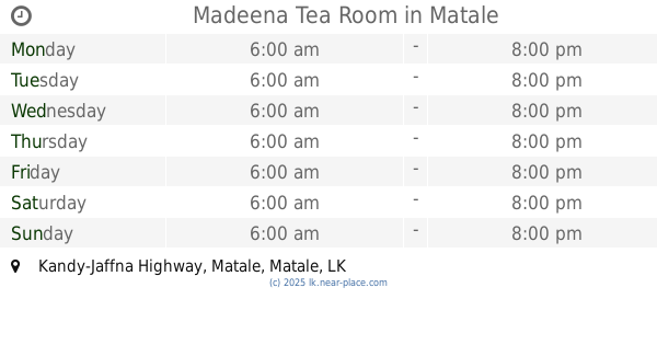
Madeena Tea Room
Kandy-Jaffna Highway, Matale
Restaurant
read more
616 m
New Rose Palace
Rose Street, Matale
Restaurant
read more
678 m
Italiano restaurant
B274, Matale
Restaurant
read more
712 m
The Taste Od Gulf Cafeteria
19/1 Kandy - Jaffna Hwy Mandandawela 21000 A9, Mandandawela
Restaurant
read more
734 m
Anura Food Center
32 Vihara Road, Matale
Restaurant
read more
880 m
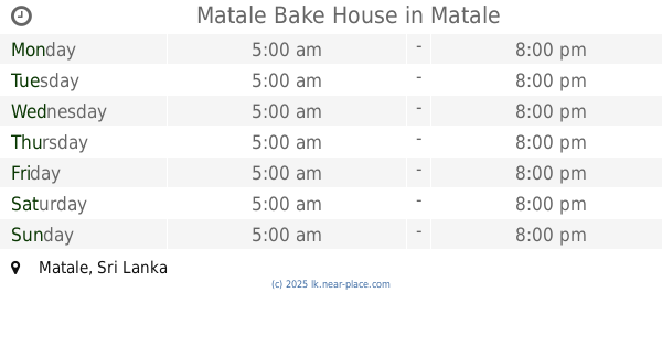
Matale Bake House
Matale
Restaurant
read more
884 m
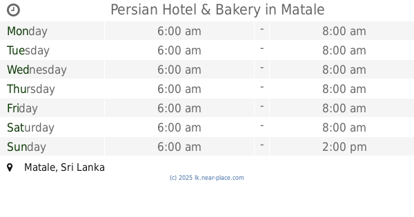
Persian Hotel & Bakery
Matale
Restaurant
read more
890 m
New Rajeswari Bhawan
Kandy-Jaffna Highway, Matale
Restaurant
read more
920 m
Corner Bake House
Gongawela Road, Matale
Restaurant
read more
939 m
Salgadu Hotel
Kandy-Jaffna Highway, Matale
Restaurant
read more
988 m
Hotel De Rio
Kottagoda, Matale
Restaurant
read more
📑
all categories
Accounting
Administrative area level 1
Administrative area level 2
Airport
Amusement park
Aquarium
Art gallery
Atm
Bakery
Bank
Bar
Beauty salon
Bicycle store
Book store
Bowling alley
Bus station
Cafe
Campground
Car dealer
Car rental
Car repair
Car wash
Casino
Cemetery
Church
City hall
Clothing store
Colloquial area
Convenience store
Country
Courthouse
Dentist
Department store
Doctor
Electrician
Electronics store
Embassy
Finance
Fire station
Florist
Food
Funeral home
Furniture store
Gas station
General contractor
Grocery or supermarket
Gym
Hair care
Hardware store
Health
Hindu Temple
Home goods store
Hospital
Insurance agency
Intersection
Jewelry store
Laundry
Lawyer
Library
Light rail station
Liquor store
Local government office
Locality
Locksmith
Lodging
Meal delivery
Meal takeaway
Mosque
Movie rental
Movie theater
Moving company
Museum
Natural feature
Neighborhood
Night club
Painter
Park
Parking
Pet store
Pharmacy
Physiotherapist
Place of worship
Plumber
Point of interest
Police
Political
Post office
Premise
Real estate agency
Restaurant
Roofing contractor
Route
Rv park, camping
School
Shoe store
Shopping mall
Spa
Stadium
Storage
Store
Subpremise
Supermarket
Synagogue
Taxi stand
Train station
Transit station
Travel agency
University
Veterinary care
Zoo
administrative area level 3
sublocality level 1
sublocality level 2
↑