Restaurant nearby Feel Eat
Sri Lanka
Restaurant nearby Feel Eat
Feel Eat
Kurunegala, Sri Lanka
contacts phone
:
+94 76 315 2880
Latitude:
7.3195043
, Longitude:
80.1191755
larger map & directions
read more
nearest Restaurant
33 m
Giriulla Resort
Colombo Road B322
Restaurant
read more
424 m
Ayansa Family Restaurent
Negombo - Giriulla Road, Loluwagoda
Restaurant
read more
990 m
Hotel Asha
Negombo-Kurunegala Road, Giriulla
Restaurant
read more
1.104 km
Deshaka Gateway Hotel
Negombo-Kurunegala Road, Giriulla
Restaurant
read more
1.158 km
Barcelos Ultimate Restaurant
Giriulla
Restaurant
read more
1.168 km
Sarasavi Hotel & Becker
Main Street, Colombo
Restaurant
read more
1.261 km
Jayabima Hotel
Giriulla
Restaurant
read more
1.294 km
Mathara Bath Kadaya
Meddepola Road, Giriulla
Restaurant
read more
1.486 km
Liyanra Restaurant
No. 126, Main street, Giriulla
Restaurant
read more
1.497 km
Ulu Gedara
Sri Lanka
Restaurant
read more
1.663 km
Mankada Hotel
Kurunegala Road, Giriulla
Restaurant
read more
2.184 km
Gedara
Kurunegala Road, Giriulla
Restaurant
read more
2.473 km
JanaJaya Guest House
Negombo - Giriulla Road, Loluwagoda
Restaurant
read more
2.628 km
Lucky 7 Restaurant And Caters
Nalla Road, Giriulla
Restaurant
read more
3.302 km
Katana Hotel
Puskoladeniya
Restaurant
read more
3.48 km
Sumudu Hotel
Loluwagoda
Restaurant
read more
3.952 km
අඹ සෙවන හෝටලය
Giriulla
Restaurant
read more
4.412 km
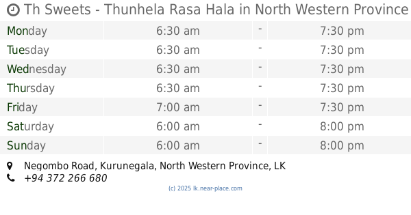
Th Sweets - Thunhela Rasa Hala
Athuruwala, Dambadeniya, Negombo Road
Restaurant
read more
4.887 km
Ishara Reception Hall & Family Food Center
7.357201, 80.142185
Restaurant
read more
4.91 km
Ishara Family Food Center
B27
Restaurant
read more
5.831 km
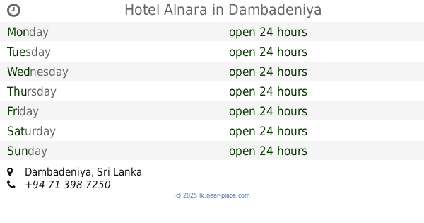
Hotel Alnara
Dambadeniya
Restaurant
read more
8.391 km
Ranwiru Rest House
B322
Restaurant
read more
10.311 km
Sakura Family Restaurant
81/c Pannala-Kuliyapitiya Road, Pannala
Restaurant
read more
13.228 km
Awanhala
Kandy Road, Ambepussa
Restaurant
read more
13.514 km
Hima Chinese Food
Warakapola
Restaurant
read more
📑
all categories
Accounting
Administrative area level 1
Administrative area level 2
Airport
Amusement park
Aquarium
Art gallery
Atm
Bakery
Bank
Bar
Beauty salon
Bicycle store
Book store
Bowling alley
Bus station
Cafe
Campground
Car dealer
Car rental
Car repair
Car wash
Casino
Cemetery
Church
City hall
Clothing store
Colloquial area
Convenience store
Country
Courthouse
Dentist
Department store
Doctor
Electrician
Electronics store
Embassy
Finance
Fire station
Florist
Food
Funeral home
Furniture store
Gas station
General contractor
Grocery or supermarket
Gym
Hair care
Hardware store
Health
Hindu Temple
Home goods store
Hospital
Insurance agency
Intersection
Jewelry store
Laundry
Lawyer
Library
Light rail station
Liquor store
Local government office
Locality
Locksmith
Lodging
Meal delivery
Meal takeaway
Mosque
Movie rental
Movie theater
Moving company
Museum
Natural feature
Neighborhood
Night club
Painter
Park
Parking
Pet store
Pharmacy
Physiotherapist
Place of worship
Plumber
Point of interest
Police
Political
Post office
Premise
Real estate agency
Restaurant
Roofing contractor
Route
Rv park, camping
School
Shoe store
Shopping mall
Spa
Stadium
Storage
Store
Subpremise
Supermarket
Synagogue
Taxi stand
Train station
Transit station
Travel agency
University
Veterinary care
Zoo
administrative area level 3
sublocality level 1
sublocality level 2
↑