Restaurant nearby Nilaro Hotel - Meegoda
Sri Lanka
Restaurant nearby Nilaro Hotel - Meegoda
Nilaro Hotel - Meegoda
Sri Lanka
contacts phone
:
+94 112 830 840
website:
www.nilarohotel.com
Latitude:
6.8461643
, Longitude:
80.0506108
larger map & directions
read more
nearest Restaurant
504 m
Dilan's Food
B240
Restaurant
read more
540 m
Ashan's Food Center
43/4,, Meegoda Road, පාදුක්ක
Restaurant
read more
567 m
Chandrasiri bakers
ශ්රී ලංකා
Restaurant
read more
592 m
Kedella Food
Gehenuwala
Restaurant
read more
642 m
Hot Bojun Restaurant
Restaurant
read more
642 m
Hot Bojun Restaurant
Sri Lanka
Restaurant
read more
898 m
NP Hotel & Bakers
Gehenuwala
Restaurant
read more
913 m
Kedella Food Center
Sri Lanka
Restaurant
read more
933 m
Hartlands City
Puwakwatta junction, Meegoda, B240
Restaurant
read more
995 m
Paradise Villa
Daham Mawatha
Restaurant
read more
1.283 km
Mihirasa Foods
B240, Homagama
Restaurant
read more
1.288 km
Millenium Chinese Garden Restaurant
Godagama South
Restaurant
read more
1.299 km
Pasco Lanka Bakers & Restaurant (Pvt) Ltd
26/28 Highlevel Rd Godagama Meegoda, A4
Restaurant
read more
1.323 km
Aswenna Restaurant
Meegoda South, 27, Avissawella Road, Colombo
Restaurant
read more
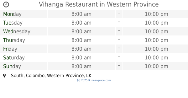
1.373 km
Vihanga Restaurant
Meegoda, South
Restaurant
read more
1.426 km
Matara Bath Kade
Sri Lanka
Restaurant
read more
1.776 km
chithrakumara Wedding Hall
Jayamuthugama
Restaurant
read more
1.855 km
King Meal Family Restaurant
B240, Homagama
Restaurant
read more
2.044 km
New Sanmiri Resturant
No 06, A4 Avissawella Road, Godagama
Restaurant
read more
2.365 km
Pasindu
Henawatta
Restaurant
read more
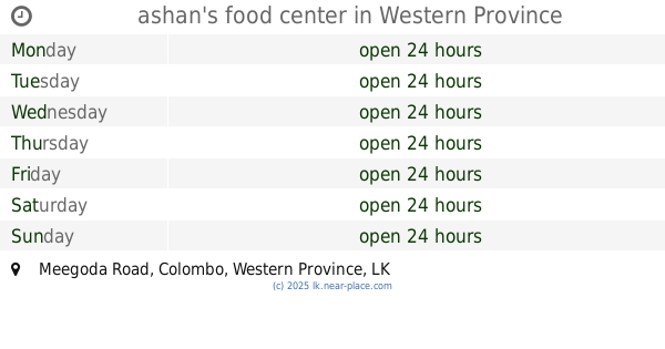
2.478 km
ashan's food center
Meegoda Road
Restaurant
read more
2.955 km
Wade Kade
Medamandiya
Restaurant
read more
3.142 km
Dinu Food
Pitipana - Thalagala Road, Homagama
Restaurant
read more
3.26 km
Tree Hut Restaurant & Take Away
Sri Lanka
Restaurant
read more
3.357 km
Salitha Hotel
Sri Lanka
Restaurant
read more
📑
all categories
Accounting
Administrative area level 1
Administrative area level 2
Airport
Amusement park
Aquarium
Art gallery
Atm
Bakery
Bank
Bar
Beauty salon
Bicycle store
Book store
Bowling alley
Bus station
Cafe
Campground
Car dealer
Car rental
Car repair
Car wash
Casino
Cemetery
Church
City hall
Clothing store
Colloquial area
Convenience store
Country
Courthouse
Dentist
Department store
Doctor
Electrician
Electronics store
Embassy
Finance
Fire station
Florist
Food
Funeral home
Furniture store
Gas station
General contractor
Grocery or supermarket
Gym
Hair care
Hardware store
Health
Hindu Temple
Home goods store
Hospital
Insurance agency
Intersection
Jewelry store
Laundry
Lawyer
Library
Light rail station
Liquor store
Local government office
Locality
Locksmith
Lodging
Meal delivery
Meal takeaway
Mosque
Movie rental
Movie theater
Moving company
Museum
Natural feature
Neighborhood
Night club
Painter
Park
Parking
Pet store
Pharmacy
Physiotherapist
Place of worship
Plumber
Point of interest
Police
Political
Post office
Premise
Real estate agency
Restaurant
Roofing contractor
Route
Rv park, camping
School
Shoe store
Shopping mall
Spa
Stadium
Storage
Store
Subpremise
Supermarket
Synagogue
Taxi stand
Train station
Transit station
Travel agency
University
Veterinary care
Zoo
administrative area level 3
sublocality level 1
sublocality level 2
↑