School nearby Kaladdy Maha Vidyalayam
Coronavirus disease (COVID-19) Situation
confirmed cases
672754
deaths
16897
Sri Lanka
School nearby Kaladdy Maha Vidyalayam
Kaladdy Maha Vidyalayam
Jaffna, Sri Lanka
contacts phone
:
+94
Latitude:
9.6863356
, Longitude:
80.0166826
larger map & directions
read more
nearest School
13 m
J/Kaladdy M.M.T.M School
Jaffna
School
read more
47 m
Sri Second Language Education Centre
72, Ramanathan Road, Jaffna
School
read more
242 m
Nisso Ict Class
Sabapathy Lane, Jaffna
School
read more
253 m
Sri Kamadchi Preschool
Jaffna
School
read more
355 m
Eddision Academy
Jaffna
School
read more
501 m
J / Ilayathambi Hindu Vidyalayam
Sivaprahasam Road, Jaffna
School
read more
560 m
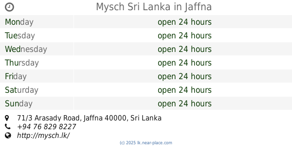
Mysch Sri Lanka
71/3 Arasady Road, Jaffna
School
read more
573 m
Periyapulam Maha Vidyalayam
Jaffna
School
read more
669 m
ACCA
Ramanathan Road, Jaffna
School
read more
703 m
Chemistry Court
88/8 Nallur-Oddumadam Road, Jaffna
School
read more
740 m
Jaffna Hindu Ladies College
Arasadi Road, Jaffna
School
read more
765 m
Anboli Institute
88/8 Nallur-Oddumadam Road, Jaffna
School
read more
786 m
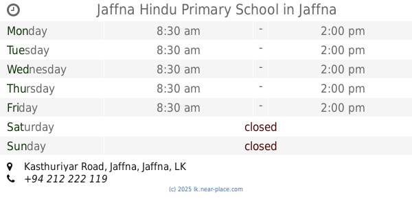
Jaffna Hindu Primary School
Kasthuriyar Road, Jaffna
School
read more
820 m
College Of ICT
Jaffna - Kokuvil Road, Jaffna
School
read more
833 m
CICT, Jaffna
Kokuvil East
School
read more
901 m
Kokkuvil Hindu Primary school
Kokuvil East
School
read more
913 m
Vidyanandan Library, University of Jaffna
Jaffna
School
read more
986 m
Jaffna Hindu College Sabalingam Hall
Jaffna
School
read more
993 m
Kalaivani Education Centre,kopay Jaffna
Palali Road, Jaffna
School
read more
995 m
J/Kokuvil Hindu Primary School
Jaffna
School
read more
1000 m
Interact Secretariat
Jaffna-Kankesanturai Road, Jaffna
School
read more
1.043 km
JHC Round of Board
Jaffna
School
read more
1.054 km
Jaffna Hindu Collge
Jaffna
School
read more
1.063 km
Cumaraswamy Hall, JHC
College Lane, Jaffna
School
read more
1.128 km
Potpathy Arivaalayam | பொற்பதி அறிவாலயம்
Potpathy Road, Nallur
School
read more
📑
all categories
Accounting
Administrative area level 1
Administrative area level 2
Airport
Amusement park
Aquarium
Art gallery
Atm
Bakery
Bank
Bar
Beauty salon
Bicycle store
Book store
Bowling alley
Bus station
Cafe
Campground
Car dealer
Car rental
Car repair
Car wash
Casino
Cemetery
Church
City hall
Clothing store
Colloquial area
Convenience store
Country
Courthouse
Dentist
Department store
Doctor
Electrician
Electronics store
Embassy
Finance
Fire station
Florist
Food
Funeral home
Furniture store
Gas station
General contractor
Grocery or supermarket
Gym
Hair care
Hardware store
Health
Hindu Temple
Home goods store
Hospital
Insurance agency
Intersection
Jewelry store
Laundry
Lawyer
Library
Light rail station
Liquor store
Local government office
Locality
Locksmith
Lodging
Meal delivery
Meal takeaway
Mosque
Movie rental
Movie theater
Moving company
Museum
Natural feature
Neighborhood
Night club
Painter
Park
Parking
Pet store
Pharmacy
Physiotherapist
Place of worship
Plumber
Point of interest
Police
Political
Post office
Premise
Real estate agency
Restaurant
Roofing contractor
Route
Rv park, camping
School
Shoe store
Shopping mall
Spa
Stadium
Storage
Store
Subpremise
Supermarket
Synagogue
Taxi stand
Train station
Transit station
Travel agency
University
Veterinary care
Zoo
administrative area level 3
sublocality level 1
sublocality level 2
↑