School nearby Kathaluwa Central College
Sri Lanka
School nearby Kathaluwa Central College
Kathaluwa Central College
Ahangama, Sri Lanka
contacts phone
:
+94
Latitude:
5.9854921
, Longitude:
80.3425465
larger map & directions
read more
nearest School
164 m
G.V.S.De Silva Primary School
Ahangama
School
read more
512 m
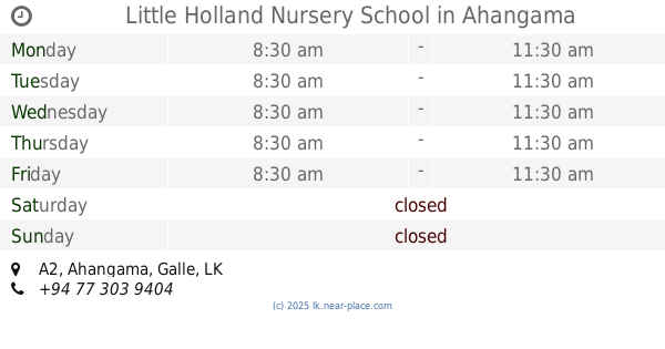
Little Holland Nursery School
A2, Ahangama
School
read more
757 m
Surf School Sri Lanka
Amaravila Kathaluwa, Ahangama
School
read more
1.015 km
SLITHM
Koggala
School
read more
1.068 km
Sri Gunarathne Vidyalaya
Ahangama
School
read more
1.204 km
Good Story Surfschool
Ahangama
School
read more
1.369 km
Siri Pemarathana Mulika Pirivena.
Welhengoda, Bogahawatta Road, Ahangama
School
read more
1.374 km
Siri Pemarathana Pirivena.
Sri Vijayasundararamaya, Bogahawatta, Ahangama
School
read more
2.393 km
Shariputhra Vidyalaya Ahangama
A2, Ahangama
School
read more
2.427 km
Shariputtra School
A2, Ahangama
School
read more
2.427 km
Sariputta School
Ahangama, A2
School
read more
2.461 km
SHARIPUTRA COLLEGE
Asian Highway 43, Ahangama
School
read more
2.585 km
Siri Wimalasiri K.V. Pelassa
Koggala
School
read more
2.589 km
Siri Wimalasiri Kanishta Vidyalaya
Ahangama
School
read more
2.873 km
Nakanda Balika Vidyalaya
Imaduwa Road, Ahangama
School
read more
2.91 km
Sunshinestories
Ahangama
School
read more
3.096 km
Sipsara Pre School
Ahangama
School
read more
3.141 km
Dombagoda Maha Vidyalaya
Dombagoda, Thitthagalla
School
read more
3.237 km
Sri Dharmarama Kanitu Vidhyalaya
Ahangama
School
read more
3.293 km
Martin Wikramasinghe Mdhya Maha Vidyalaya
Habaraduwa
School
read more
3.802 km
First Location of Dharmarama Kanitu Vidyalaya
Asian Highway 43, Ahangama
School
read more
4.076 km
Dharmika Maha Vidyalaya
Habaraduwa
School
read more
4.571 km
Andugoda K.V.
dikkumbura
School
read more
4.979 km
G/PANCHALIYA PRIMARY SCHOOL
Panchaliya - Borala Road
School
read more
5.105 km
Nethsarana Children Care Center
Galle
School
read more
📑
all categories
Accounting
Administrative area level 1
Administrative area level 2
Airport
Amusement park
Aquarium
Art gallery
Atm
Bakery
Bank
Bar
Beauty salon
Bicycle store
Book store
Bowling alley
Bus station
Cafe
Campground
Car dealer
Car rental
Car repair
Car wash
Casino
Cemetery
Church
City hall
Clothing store
Colloquial area
Convenience store
Country
Courthouse
Dentist
Department store
Doctor
Electrician
Electronics store
Embassy
Finance
Fire station
Florist
Food
Funeral home
Furniture store
Gas station
General contractor
Grocery or supermarket
Gym
Hair care
Hardware store
Health
Hindu Temple
Home goods store
Hospital
Insurance agency
Intersection
Jewelry store
Laundry
Lawyer
Library
Light rail station
Liquor store
Local government office
Locality
Locksmith
Lodging
Meal delivery
Meal takeaway
Mosque
Movie rental
Movie theater
Moving company
Museum
Natural feature
Neighborhood
Night club
Painter
Park
Parking
Pet store
Pharmacy
Physiotherapist
Place of worship
Plumber
Point of interest
Police
Political
Post office
Premise
Real estate agency
Restaurant
Roofing contractor
Route
Rv park, camping
School
Shoe store
Shopping mall
Spa
Stadium
Storage
Store
Subpremise
Supermarket
Synagogue
Taxi stand
Train station
Transit station
Travel agency
University
Veterinary care
Zoo
administrative area level 3
sublocality level 1
sublocality level 2
↑