School nearby Nenasa education centre
Sri Lanka
School nearby Nenasa education centre
Nenasa education centre
Weerapokuna Road, Weerapokuna Sri Lanka
contacts phone
:
+94
Latitude:
7.6515014
, Longitude:
79.9887156
read more
nearest School
1.421 km
Poowella Muslim Kanishta Vidyalaya
Weerapokuna Road, Weerapokuna
School
read more
1.438 km
puwakgahakadawala school
Kurunegala
School
read more
1.797 km
LEADS Academy
Kiniyama
School
read more
1.894 km
Al-Ilmiya Pre School
Kiniyama
School
read more
1.963 km
Kiniyama Muslim School
Konkadawala Road, Kiniyama
School
read more
1.968 km
Getulawa School
Kurunegala
School
read more
1.995 km
Kiniyama School
Konkadawala Road, Kiniyama
School
read more
2.236 km
Koonkandawala Vidyalaya
Manelembuwa Road, koonkandawala
School
read more
2.347 km
Hiripokuna Government School
Hiripokuna, Weerapokuna, Sri Lanka.
School
read more
2.347 km
Muthuhara Perapaasla
Welpothuwewa - Kobeigane Road
School
read more
2.391 km
Makullapokuna Kanishta Vidyalaya
Weerapokuna
School
read more
2.839 km
sigithi preschool kiniyama
Kiniyama
School
read more
3.181 km
Kiniyama Sinhala School
Manalembuwa Rd Kiniyama
School
read more
3.581 km
Thisogama Sripali Maha Vidyalaya
Bowatte - Getulawa Road
School
read more
3.651 km
Asanakotuwa MV
Kurunegala
School
read more
5.208 km
Brahmanayagama Saddhanandha Maha Vidyalaya
Sri Lanka
School
read more
5.223 km
Sri Saddhananda M. Vidyalaya
60450, Brahmanayagama Prasannagama Road, Bingiriya
School
read more
5.298 km
Sri Sarananda Maha Vidyalaya
manelembuwa, Dhaduhavila Road
School
read more
5.369 km
Al Ilmiya Muslim Maha Vidyalaya
Welpothuwewa
School
read more
5.394 km
Al Ilmiya M.V
Welpothuwewa
School
read more
5.425 km
Al Humaija Pre School
Welpothuwewa
School
read more
6.39 km
Wathupola Maha Widuhala
Pallama
School
read more
8.089 km
Pre School
Kurunegala
School
read more
13.116 km
Pannawa Muslim Central College
Masjid Road, Neelasandra, Bengaluru
School
read more
14.958 km
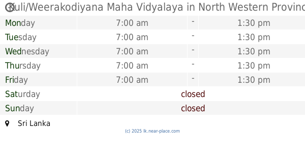
Kuli/Weerakodiyana Maha Vidyalaya
Sri Lanka
School
read more
📑
all categories
Accounting
Administrative area level 1
Administrative area level 2
Airport
Amusement park
Aquarium
Art gallery
Atm
Bakery
Bank
Bar
Beauty salon
Bicycle store
Book store
Bowling alley
Bus station
Cafe
Campground
Car dealer
Car rental
Car repair
Car wash
Casino
Cemetery
Church
City hall
Clothing store
Colloquial area
Convenience store
Country
Courthouse
Dentist
Department store
Doctor
Electrician
Electronics store
Embassy
Finance
Fire station
Florist
Food
Funeral home
Furniture store
Gas station
General contractor
Grocery or supermarket
Gym
Hair care
Hardware store
Health
Hindu Temple
Home goods store
Hospital
Insurance agency
Intersection
Jewelry store
Laundry
Lawyer
Library
Light rail station
Liquor store
Local government office
Locality
Locksmith
Lodging
Meal delivery
Meal takeaway
Mosque
Movie rental
Movie theater
Moving company
Museum
Natural feature
Neighborhood
Night club
Painter
Park
Parking
Pet store
Pharmacy
Physiotherapist
Place of worship
Plumber
Point of interest
Police
Political
Post office
Premise
Real estate agency
Restaurant
Roofing contractor
Route
Rv park, camping
School
Shoe store
Shopping mall
Spa
Stadium
Storage
Store
Subpremise
Supermarket
Synagogue
Taxi stand
Train station
Transit station
Travel agency
University
Veterinary care
Zoo
administrative area level 3
sublocality level 1
sublocality level 2
↑