Store nearby ජගත් බුලත් කඩේ
Sri Lanka
Store nearby ජගත් බුලත් කඩේ
ජගත් බුලත් කඩේ
Meethotamulla, Sri Lanka
contacts phone
:
+94
Latitude:
6.9315724
, Longitude:
79.8837225
larger map & directions
read more
nearest Store
145 m
Power Plant. Kolonnawa.
Meethotamulla
Store
read more
189 m
CEB Workshop
Sri Lanka
Store
read more
457 m
Infinity Gaming Cafe
114/1, Kolonnawa Road, Dematagoda, Colombo 09
Store
read more
477 m
Vision On
Veluwana Road, Colombo
Store
read more
526 m
Pc Care
7/56,1b,Aaramya place,dematagoda,colombo-09, Colombo
Store
read more
567 m
Smart Solutions
No:10,, Sri Dharmarama Road, Dematagoda Colombo 09
Store
read more
571 m
Zero.lk
No:10, Sri Dharmarama Road, Dematagoda, Colombo Sri lanka
Store
read more
587 m
Vitharana Industries
Meethotamulla
Store
read more
593 m
Weeratunga Brothers
Kolonnawa Road, Colombo
Store
read more
614 m
Dharshana Sinhala Beheth Velendasela
Wanathamulla, Colombo
Store
read more
637 m
Mister Mobile
No. 04, Kent Road, Colombo
Store
read more
693 m
PSK LITRO Gas\ගෑස් Center
63/37, Baseline Ave. Colombo 9. Phone-011 2 670520, Dematagoda, Colombo
Store
read more
722 m
MSM Trade Center
Maligawatta East, Colombo
Store
read more
724 m
New Fancy Plaza
Wanathamulla, Colombo
Store
read more
729 m
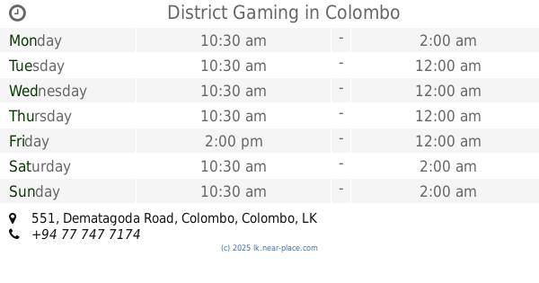
District Gaming
551 Dematagoda Road, Colombo
Store
read more
887 m
ideal stuff
Dematagoda Place, Colombo
Store
read more
943 m
Melting Moments
8/1, Kappetipola Road, Kolonnawa
Store
read more
958 m
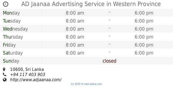
AD Jaanaa Advertising Service
Sri Lanka
Store
read more
978 m
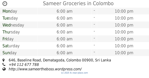
Sameer Groceries
646, Baseline Road, Dematagoda, Colombo
Store
read more
1.009 km
Last chance
No.351 kehelwala kiribathkumbura, Peradeniya
Store
read more
1.099 km
RumHiru Photography
20, Mount Avenue, Colombo
Store
read more
1.217 km
witchfeather
Karlshrue Gardens, Colombo
Store
read more
1.233 km
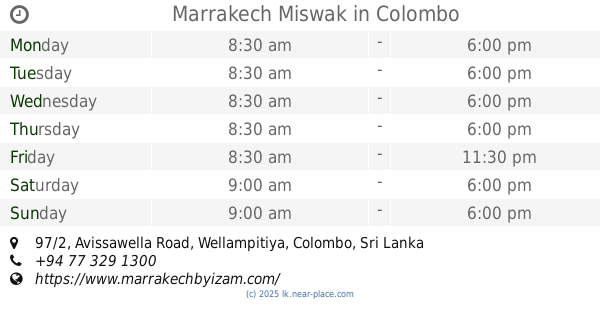
Marrakech Miswak
97/2, Avissawella Road, Wellampitiya, Colombo
Store
read more
1.235 km
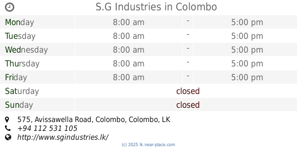
S.G Industries
575 Avissawella Road, Colombo
Store
read more
1.298 km
RM TRADERS
263/4, Khettarama Temple Road, Colombo
Store
read more
📑
all categories
Accounting
Administrative area level 1
Administrative area level 2
Airport
Amusement park
Aquarium
Art gallery
Atm
Bakery
Bank
Bar
Beauty salon
Bicycle store
Book store
Bowling alley
Bus station
Cafe
Campground
Car dealer
Car rental
Car repair
Car wash
Casino
Cemetery
Church
City hall
Clothing store
Colloquial area
Convenience store
Country
Courthouse
Dentist
Department store
Doctor
Electrician
Electronics store
Embassy
Finance
Fire station
Florist
Food
Funeral home
Furniture store
Gas station
General contractor
Grocery or supermarket
Gym
Hair care
Hardware store
Health
Hindu Temple
Home goods store
Hospital
Insurance agency
Intersection
Jewelry store
Laundry
Lawyer
Library
Light rail station
Liquor store
Local government office
Locality
Locksmith
Lodging
Meal delivery
Meal takeaway
Mosque
Movie rental
Movie theater
Moving company
Museum
Natural feature
Neighborhood
Night club
Painter
Park
Parking
Pet store
Pharmacy
Physiotherapist
Place of worship
Plumber
Point of interest
Police
Political
Post office
Premise
Real estate agency
Restaurant
Roofing contractor
Route
Rv park, camping
School
Shoe store
Shopping mall
Spa
Stadium
Storage
Store
Subpremise
Supermarket
Synagogue
Taxi stand
Train station
Transit station
Travel agency
University
Veterinary care
Zoo
administrative area level 3
sublocality level 1
sublocality level 2
↑