Store nearby Agaram pharmachy
Coronavirus disease (COVID-19) Situation
confirmed cases
672754
deaths
16897
Sri Lanka
Store nearby Agaram pharmachy
Agaram pharmachy
Jaffna, Sri Lanka
contacts phone
:
+94
Latitude:
9.7046118
, Longitude:
80.069332
larger map & directions
read more
nearest Store
29 m
Thirumagal Pharmacy
road kopay jaffna, Point Pedro
Store
read more
64 m
Mithiran multi shop
Road kopay, Manipay
Store
read more
69 m
Anna Timber Store
Road kopay, Manipay
Store
read more
175 m
Kuddy stores
Jaffna
Store
read more
181 m
Ganesh trailers
Jaffna
Store
read more
353 m
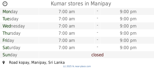
Kumar stores
Road kopay, Manipay
Store
read more
395 m
Usha Multi Centre
Road Kopay Jaffna, Point Pedro
Store
read more
463 m
Navalar Printers
AB20, Kopay Central, Kopay, Jaffna
Store
read more
508 m
Co-operaty Store Kopay
Manipay-Kaitadi Road, Jaffna
Store
read more
749 m
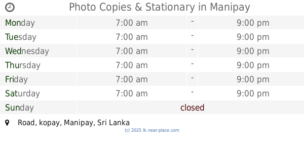
Photo Copies & Stationary
Road, kopay, Manipay
Store
read more
808 m
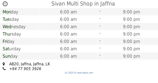
Sivan Multi Shop
AB20, Jaffna
Store
read more
870 m
Kumar Stores
Manipay-Kaitadi Road, Jaffna
Store
read more
1.034 km
Kavi Stores
B268, Jaffna
Store
read more
1.219 km
Sannathy Farm Centre
Dżafna
Store
read more
1.219 km
Sannathy Farm Centre
Jaffna
Store
read more
1.246 km
Thampimuththu Multi Shop
Jaffna
Store
read more
1.262 km
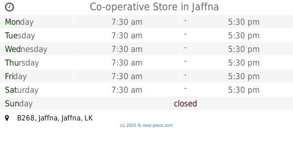
Co-operative Store
B268, Jaffna
Store
read more
1.681 km
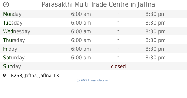
Parasakthi Multi Trade Centre
B268, Jaffna
Store
read more
1.805 km
TELE CHOICE Phone & Accessories
No. 03, Old post office Lane, Koppay South, Koppay, Jaffna, AB20, Jaffna
Store
read more
2.14 km
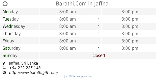
Barathi.Com
Dżafna
Store
read more
2.14 km
Barathi.Com
Jaffna
Store
read more
2.273 km
Yaso Timbe Work Shop
Jaffna
Store
read more
3.081 km
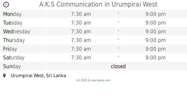
A.K.S Communication
Urumpirai West
Store
read more
3.087 km
Ruban Store
Urumpirai West
Store
read more
3.555 km
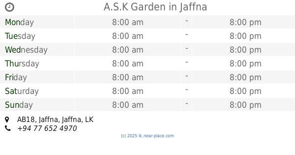
A.S.K Garden
AB18, Jaffna
Store
read more
📑
all categories
Accounting
Administrative area level 1
Administrative area level 2
Airport
Amusement park
Aquarium
Art gallery
Atm
Bakery
Bank
Bar
Beauty salon
Bicycle store
Book store
Bowling alley
Bus station
Cafe
Campground
Car dealer
Car rental
Car repair
Car wash
Casino
Cemetery
Church
City hall
Clothing store
Colloquial area
Convenience store
Country
Courthouse
Dentist
Department store
Doctor
Electrician
Electronics store
Embassy
Finance
Fire station
Florist
Food
Funeral home
Furniture store
Gas station
General contractor
Grocery or supermarket
Gym
Hair care
Hardware store
Health
Hindu Temple
Home goods store
Hospital
Insurance agency
Intersection
Jewelry store
Laundry
Lawyer
Library
Light rail station
Liquor store
Local government office
Locality
Locksmith
Lodging
Meal delivery
Meal takeaway
Mosque
Movie rental
Movie theater
Moving company
Museum
Natural feature
Neighborhood
Night club
Painter
Park
Parking
Pet store
Pharmacy
Physiotherapist
Place of worship
Plumber
Point of interest
Police
Political
Post office
Premise
Real estate agency
Restaurant
Roofing contractor
Route
Rv park, camping
School
Shoe store
Shopping mall
Spa
Stadium
Storage
Store
Subpremise
Supermarket
Synagogue
Taxi stand
Train station
Transit station
Travel agency
University
Veterinary care
Zoo
administrative area level 3
sublocality level 1
sublocality level 2
↑