Store nearby Araliya Flower Nursery
Sri Lanka
Store nearby Araliya Flower Nursery
Araliya Flower Nursery
Ragama, Sri Lanka
contacts phone
:
+94
Latitude:
7.0489472
, Longitude:
79.9184132
larger map & directions
read more
nearest Store
811 m
Salon Sathika
219/5/3 Kopiyawaththa Ragama
Store
read more
857 m
Nethindu Stores
Ragama
Store
read more
1.017 km
Maharamba Stores
Batuwatta
Store
read more
1.039 km
Printair
67/D/1, Uggashena,Walpole,, Ragama
Store
read more
1.165 km
Amare Store
Batuwatta
Store
read more
1.407 km
Ragama tyre center
Ragama
Store
read more
1.426 km
R.K.S Phone Shop
Peralanda Road, Ragama
Store
read more
1.52 km
Mebal Stores
Shakthi Mawatha, Ragama
Store
read more
1.552 km
Quality School Bags
471/D, Gane Road, Ragama
Store
read more
1.598 km
U KNOW WHO'S
573/C Linton Road, Ragama
Store
read more
1.612 km
Siri Timber Suppliers
Kandana
Store
read more
1.667 km
optimo international
no 16/1 gunasekara road,mabola,waththala
Store
read more
1.702 km
Ruwan Stores
Ja-Ela
Store
read more
1.738 km
Freee game downloads
541/h,Ransiri mawatha, Narangodapaluwa, Batuwatte, Ragama, Ragama
Store
read more
1.782 km
Samanala Stationery Shop
Batuwatta
Store
read more
1.783 km
S.N. Traders
Batuwatta
Store
read more
1.868 km
Nenila Enterprices
Ragama
Store
read more
1.933 km
Batuwatta Co-operative Shop
Ragama Kadana Road, Ja-Ela
Store
read more
1.991 km
Palihawadana Vision Optics
Ragama
Store
read more
1.998 km
Sanitma Traders
No.44, Thewatta road, Ragama
Store
read more
2.014 km
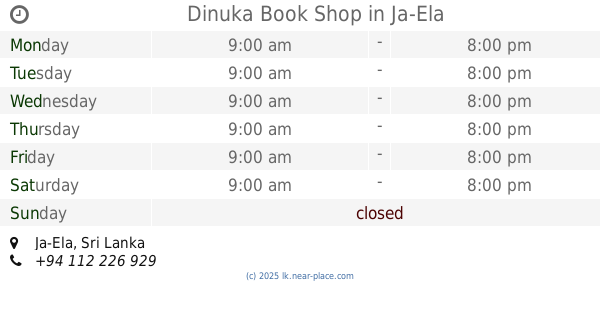
Dinuka Book Shop
Ja-Ela
Store
read more
2.019 km
Pc Mobile
110 4 Thewatta Road, Ragama
Store
read more
2.093 km
Islandwide Marketing Services (Pvt) Ltd
Ragama
Store
read more
2.424 km
Statue Of Jesus
Nugagahawattha Nawaloka Vihara Mawatha, Ragama
Store
read more
2.442 km
Basilica Souvenior Shop
Ragama
Store
read more
📑
all categories
Accounting
Administrative area level 1
Administrative area level 2
Airport
Amusement park
Aquarium
Art gallery
Atm
Bakery
Bank
Bar
Beauty salon
Bicycle store
Book store
Bowling alley
Bus station
Cafe
Campground
Car dealer
Car rental
Car repair
Car wash
Casino
Cemetery
Church
City hall
Clothing store
Colloquial area
Convenience store
Country
Courthouse
Dentist
Department store
Doctor
Electrician
Electronics store
Embassy
Finance
Fire station
Florist
Food
Funeral home
Furniture store
Gas station
General contractor
Grocery or supermarket
Gym
Hair care
Hardware store
Health
Hindu Temple
Home goods store
Hospital
Insurance agency
Intersection
Jewelry store
Laundry
Lawyer
Library
Light rail station
Liquor store
Local government office
Locality
Locksmith
Lodging
Meal delivery
Meal takeaway
Mosque
Movie rental
Movie theater
Moving company
Museum
Natural feature
Neighborhood
Night club
Painter
Park
Parking
Pet store
Pharmacy
Physiotherapist
Place of worship
Plumber
Point of interest
Police
Political
Post office
Premise
Real estate agency
Restaurant
Roofing contractor
Route
Rv park, camping
School
Shoe store
Shopping mall
Spa
Stadium
Storage
Store
Subpremise
Supermarket
Synagogue
Taxi stand
Train station
Transit station
Travel agency
University
Veterinary care
Zoo
administrative area level 3
sublocality level 1
sublocality level 2
↑