Store nearby Nanayakkara Stores
Sri Lanka
Store nearby Nanayakkara Stores
Nanayakkara Stores
Karandana Road, Ratnapura, Sabaragamuwa Province, LK Sri Lanka
contacts phone
:
+94
Latitude:
6.7527691
, Longitude:
80.2226615
larger map & directions
read more
nearest Store
1.342 km
Madala Rubber Stores
Ratnapura
Store
read more
1.47 km
Fruits and Vegitables
Ratnapura
Store
read more
2.83 km
Regal Calibre LK Ltd
Kurugammodara, Kiriella,
Store
read more
3.989 km
Wasantha Stores
Ratnapura - Horana - Panadura Highway
Store
read more
4.675 km
AKP Motors
Ingiriya
Store
read more
4.689 km
AkP Motors
rathnapura road, Ingiriya
Store
read more
5.155 km
Green Plaza
A8, Ingiriya
Store
read more
5.597 km
Kithulahena Estate
Sri Lanka
Store
read more
9.528 km
Dilini Stores
A8, Ingiriya
Store
read more
9.668 km
Hddes Extracts (Pvt) Ltd
HEPZ, Boralugoda, Poruwedanda, A8, Horana
Store
read more
10.15 km
Athukorala Saw Mills & Timber Shop
Kalutara
Store
read more
10.764 km
Pemarathna Shop
Pohorabawa Road, Pohorabawa
Store
read more
10.971 km
Amalinfotech
Amalinfotech
Store
read more
11.456 km
singithi stores
thalawitiya waththa Road, Eheliyagoda
Store
read more
11.651 km
Majestic Paints
618, 618/b/1 Colombo - Batticaloa Highway, Eheliyagoda
Store
read more
11.7 km
Siyana Eheliyagoda
6°50'59. 80°15'49., 3"N 2nd Lane, Maharagama
Store
read more
12.008 km
New City Farm Shop
Vijaya Kumaratunga Road, Eheliyagoda
Store
read more
12.065 km
chathura graphics
6.854143, 80.261662, Vijaya Kumaratunga Road
Store
read more
12.073 km
S,M.LANKA AUTO ACCESSORICE (PVT) LTD
Eheliyagoda
Store
read more
12.269 km
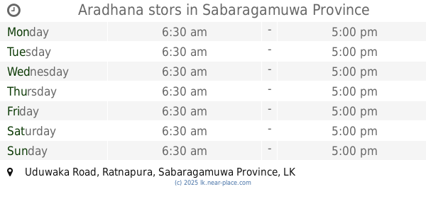
Aradhana stors
Uduwaka Road
Store
read more
13.636 km
Thummodara Stores
B188
Store
read more
14.6 km
Kumarasiri Welding Works
B240, Padukka
Store
read more
14.673 km
Technomate Battery Traiding
Rathnapura Road,ilimba, Horana
Store
read more
17.604 km
Hotline Cellular
Padukka
Store
read more
19.242 km
Wimala Stores
Kalutara
Store
read more
📑
all categories
Accounting
Administrative area level 1
Administrative area level 2
Airport
Amusement park
Aquarium
Art gallery
Atm
Bakery
Bank
Bar
Beauty salon
Bicycle store
Book store
Bowling alley
Bus station
Cafe
Campground
Car dealer
Car rental
Car repair
Car wash
Casino
Cemetery
Church
City hall
Clothing store
Colloquial area
Convenience store
Country
Courthouse
Dentist
Department store
Doctor
Electrician
Electronics store
Embassy
Finance
Fire station
Florist
Food
Funeral home
Furniture store
Gas station
General contractor
Grocery or supermarket
Gym
Hair care
Hardware store
Health
Hindu Temple
Home goods store
Hospital
Insurance agency
Intersection
Jewelry store
Laundry
Lawyer
Library
Light rail station
Liquor store
Local government office
Locality
Locksmith
Lodging
Meal delivery
Meal takeaway
Mosque
Movie rental
Movie theater
Moving company
Museum
Natural feature
Neighborhood
Night club
Painter
Park
Parking
Pet store
Pharmacy
Physiotherapist
Place of worship
Plumber
Point of interest
Police
Political
Post office
Premise
Real estate agency
Restaurant
Roofing contractor
Route
Rv park, camping
School
Shoe store
Shopping mall
Spa
Stadium
Storage
Store
Subpremise
Supermarket
Synagogue
Taxi stand
Train station
Transit station
Travel agency
University
Veterinary care
Zoo
administrative area level 3
sublocality level 1
sublocality level 2
↑