University nearby Faculty of Education, University of Colombo
Sri Lanka
University nearby Faculty of Education, University of Colombo
Faculty of Education, University of Colombo
Bauddhaloka Mawatha, 00700, Colombo, Colombo, LK Sri Lanka
contacts phone
:
+94 112 588 812
Latitude:
6.8994995
, Longitude:
79.8635641
larger map & directions
read more
nearest University
212 m
Faculty of Law, University of Colombo
Philip Gunewardena Mawatha, Colombo
University
read more
219 m
Department of Geography, University of Colombo
Colombo
University
read more
256 m
Colombo University
Reid Avenue, Philip Gunewardena Mawatha, Colombo
University
read more
289 m
Institute of Supply and Materials Management
OPA Building, Professional Centre, 275/75 Prof Stanley Wijesundera Mawatha, Colombo
University
read more
310 m
University New Art Faculty Buildings
Prof Stanley Wijesundera Mawatha, Colombo
University
read more
415 m
Department of Statistics
Colombo - Batticaloa Highway, Colombo
University
read more
435 m
Oxford College of Business
No 100, Thurstan Road, Colombo
University
read more
552 m
Thurstan College Senior Section
Thurstan College Senior Section, Colombo
University
read more
828 m
Spectrum Institute of Science & Technology - Undergraduate Facility
100 Bauddhaloka Mawatha, Colombo
University
read more
943 m
Fathima Hostal
Colombo
University
read more
998 m
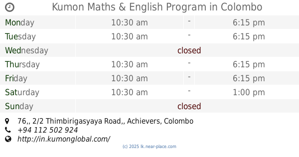
Kumon Maths & English Program
76,, 2/2 Thimbirigasyaya Road,, Achievers, Colombo
University
read more
1.084 km
Pioneer Institute of Business & Technology
Sir Ernest de Silva Mawatha, Colombo
University
read more
1.112 km
National Institute of Business Management
Vidya Mawatha, Colombo
University
read more
1.169 km
Hegoda School of Photography
89, First Floor, Galle Road, Colombo
University
read more
1.224 km
Sri Lanka College of Journalism (SLCJ)
96 Kirula Road, Colombo
University
read more
📑
all categories
Accounting
Administrative area level 1
Administrative area level 2
Airport
Amusement park
Aquarium
Art gallery
Atm
Bakery
Bank
Bar
Beauty salon
Bicycle store
Book store
Bowling alley
Bus station
Cafe
Campground
Car dealer
Car rental
Car repair
Car wash
Casino
Cemetery
Church
City hall
Clothing store
Colloquial area
Convenience store
Country
Courthouse
Dentist
Department store
Doctor
Electrician
Electronics store
Embassy
Finance
Fire station
Florist
Food
Funeral home
Furniture store
Gas station
General contractor
Grocery or supermarket
Gym
Hair care
Hardware store
Health
Hindu Temple
Home goods store
Hospital
Insurance agency
Intersection
Jewelry store
Laundry
Lawyer
Library
Light rail station
Liquor store
Local government office
Locality
Locksmith
Lodging
Meal delivery
Meal takeaway
Mosque
Movie rental
Movie theater
Moving company
Museum
Natural feature
Neighborhood
Night club
Painter
Park
Parking
Pet store
Pharmacy
Physiotherapist
Place of worship
Plumber
Point of interest
Police
Political
Post office
Premise
Real estate agency
Restaurant
Roofing contractor
Route
Rv park, camping
School
Shoe store
Shopping mall
Spa
Stadium
Storage
Store
Subpremise
Supermarket
Synagogue
Taxi stand
Train station
Transit station
Travel agency
University
Veterinary care
Zoo
administrative area level 3
sublocality level 1
sublocality level 2
↑