Atm nearby HNB
Sri Lanka
Atm nearby HNB
HNB
Boralesgamuwa East A, Boralesgamuwa, Sri Lanka
contacts phone
:
+94 112 516 533
website:
www.hnb.lk
Latitude:
6.8409649
, Longitude:
79.9024059
larger map & directions
read more
nearest Atm
54 m
National Savings Bank ATM
Boralesgamuwa
Atm
read more
59 m
Peoples Bank ATM
27/8B Lake Road, Boralesgamuwa
Atm
read more
79 m
NDB ATM
Boralesgamuwa East A, Boralesgamuwa
Atm
read more
124 m
Bank of Ceylon ලංකා බැංකුව
No 50, Lake Road, Boralesgamuwa
Atm
read more
270 m
Seylan Bank ATM
Boralesgamuwa West, A
Atm
read more
283 m
Commercial Bank ATM
Boralesgamuwa
Atm
read more
499 m
Sampath Bank ATM
Boralesgamuwa
Atm
read more
1.006 km
Union Bank (ATM)
Boralesgamuwa West A, Boralesgamuwa
Atm
read more
1.402 km
People's Bank ATM
Nugegoda
Atm
read more
1.406 km
Sampath Bank ATM
Dehiwala-Mount Lavinia
Atm
read more
1.422 km
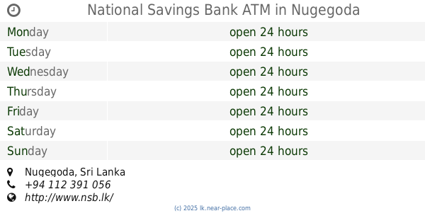
National Savings Bank ATM
Nugegoda
Atm
read more
1.725 km
Commercial Bank Standalone ATM
Department of Mortor Traffic, Boralesgamuwa
Atm
read more
1.957 km
Commercial Bank ATM
Ratmalana - Mirihana Road, Dehiwala-Mount Lavinia
Atm
read more
1.957 km
Nations Trust Bank ATM
Dehiwala-Mount Lavinia
Atm
read more
1.959 km
HNB ATM
Maharagama
Atm
read more
1.997 km
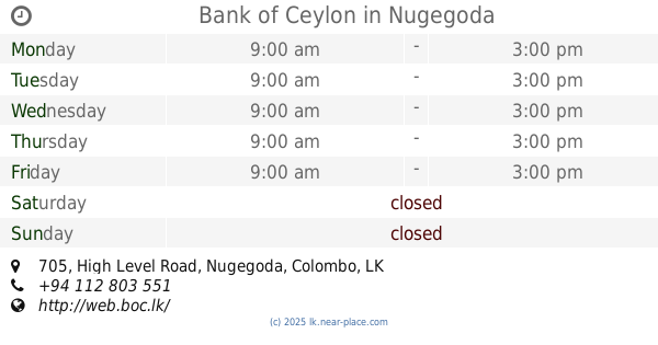
Bank of Ceylon
705 High Level Road, Nugegoda
Atm
read more
2.037 km
Commercial Bank Atm
Dehiwala-Mount Lavinia
Atm
read more
2.059 km
People's Bank ATM
Avissawella Road, Nugegoda
Atm
read more
2.089 km
HSBC ATM
Maharagama
Atm
read more
2.134 km
Commercial Bank ATM
Navinna Arpico Super Center, Avissawella Road, Maharagama
Atm
read more
2.139 km
NTB ATM
Colombo - Batticaloa Highway, Maharagama
Atm
read more
2.202 km
Bimputh Finance ATM
No.362, Colombo Road, Pepiliyana, Boralesgamuwa
Atm
read more
2.278 km
SET ATM
230 Avissawella Road, Maharagama
Atm
read more
2.278 km
Sampath Bank ATM
Wattegedara, Avissawella Road, Maharagama
Atm
read more
2.326 km
HNB ATM
Bellanthara Road, Dehiwala-Mount Lavinia
Atm
read more
📑
all categories
Accounting
Administrative area level 1
Administrative area level 2
Airport
Amusement park
Aquarium
Art gallery
Atm
Bakery
Bank
Bar
Beauty salon
Bicycle store
Book store
Bowling alley
Bus station
Cafe
Campground
Car dealer
Car rental
Car repair
Car wash
Casino
Cemetery
Church
City hall
Clothing store
Colloquial area
Convenience store
Country
Courthouse
Dentist
Department store
Doctor
Electrician
Electronics store
Embassy
Finance
Fire station
Florist
Food
Funeral home
Furniture store
Gas station
General contractor
Grocery or supermarket
Gym
Hair care
Hardware store
Health
Hindu Temple
Home goods store
Hospital
Insurance agency
Intersection
Jewelry store
Laundry
Lawyer
Library
Light rail station
Liquor store
Local government office
Locality
Locksmith
Lodging
Meal delivery
Meal takeaway
Mosque
Movie rental
Movie theater
Moving company
Museum
Natural feature
Neighborhood
Night club
Painter
Park
Parking
Pet store
Pharmacy
Physiotherapist
Place of worship
Plumber
Point of interest
Police
Political
Post office
Premise
Real estate agency
Restaurant
Roofing contractor
Route
Rv park, camping
School
Shoe store
Shopping mall
Spa
Stadium
Storage
Store
Subpremise
Supermarket
Synagogue
Taxi stand
Train station
Transit station
Travel agency
University
Veterinary care
Zoo
administrative area level 3
sublocality level 1
sublocality level 2
↑