Bakery nearby New Empire Bakery
Sri Lanka
Bakery nearby New Empire Bakery
New Empire Bakery
Batticaloa, Sri Lanka
contacts phone
:
+94
Latitude:
7.7203648
, Longitude:
81.6961796
larger map & directions
read more
nearest Bakery
590 m
Vasanthan Bakery
B46, Batticaloa
Bakery
read more
598 m
Top bakery
Batticaloa
Bakery
read more
741 m
Vasanth Bake House & Cool Bar
Batticaloa
Bakery
read more
782 m
Sunshine Fast
New Kalmunai Road, Batticaloa
Bakery
read more
926 m
The New Bakery & Grocery
Advocate's Road, Batticaloa
Bakery
read more
1.074 km
Allffa Bakery
Nothari's lane, மட்டக்களப்பு
Bakery
read more
1.296 km
Sothi Stores
Koolavadi Main Road, Batticaloa
Bakery
read more
1.369 km
Nixon Bakery Hotel
Sri Lanka
Bakery
read more
1.758 km
Double T Bakery & Restaurant
Kallady
Bakery
read more
5.401 km
Rafeek Bakery
Colombo - Batticaloa Highway, Kattankudy
Bakery
read more
5.416 km
Al Gaya Restaurant & Bakery
Methapalli Road, Kattankudy
Bakery
read more
5.43 km
Paradise Bakery
B337, Kattankudy
Bakery
read more
5.43 km
Paradise Bakery
Old Road, Kattankudy
Bakery
read more
5.796 km
New French Bakery
Kattankudy
Bakery
read more
5.885 km
Fashion Bakery
Doctor Badhiudeen Mahmood Mawatha, Kattankudy
Bakery
read more
10.18 km
B.C Bakery
Sri Lanka
Bakery
read more
11.599 km
Nawas Bakery
Town, Eravur
Bakery
read more
11.701 km
Najath Bake House
Town, Eravur
Bakery
read more
12.011 km
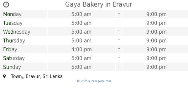
Gaya Bakery
Town,, Eravur
Bakery
read more
12.043 km
Mina Bake House
Eravur
Bakery
read more
12.65 km
Suba Bakery
Town, Eravur
Bakery
read more
13.613 km
Aperrame Bakery & Cafe
Chenkaladi
Bakery
read more
13.69 km
Central Bakery & Restaurant
Chenkaladi
Bakery
read more
24.528 km
Papitha Bakery
Kaluwanchikudi - Vellaveli Road
Bakery
read more
29.377 km
Hairath Bakery
04 Ymma Cross Road
Bakery
read more
📑
all categories
Accounting
Administrative area level 1
Administrative area level 2
Airport
Amusement park
Aquarium
Art gallery
Atm
Bakery
Bank
Bar
Beauty salon
Bicycle store
Book store
Bowling alley
Bus station
Cafe
Campground
Car dealer
Car rental
Car repair
Car wash
Casino
Cemetery
Church
City hall
Clothing store
Colloquial area
Convenience store
Country
Courthouse
Dentist
Department store
Doctor
Electrician
Electronics store
Embassy
Finance
Fire station
Florist
Food
Funeral home
Furniture store
Gas station
General contractor
Grocery or supermarket
Gym
Hair care
Hardware store
Health
Hindu Temple
Home goods store
Hospital
Insurance agency
Intersection
Jewelry store
Laundry
Lawyer
Library
Light rail station
Liquor store
Local government office
Locality
Locksmith
Lodging
Meal delivery
Meal takeaway
Mosque
Movie rental
Movie theater
Moving company
Museum
Natural feature
Neighborhood
Night club
Painter
Park
Parking
Pet store
Pharmacy
Physiotherapist
Place of worship
Plumber
Point of interest
Police
Political
Post office
Premise
Real estate agency
Restaurant
Roofing contractor
Route
Rv park, camping
School
Shoe store
Shopping mall
Spa
Stadium
Storage
Store
Subpremise
Supermarket
Synagogue
Taxi stand
Train station
Transit station
Travel agency
University
Veterinary care
Zoo
administrative area level 3
sublocality level 1
sublocality level 2
↑