Bakery nearby Rathnayake Bakery
Sri Lanka
Bakery nearby Rathnayake Bakery
Rathnayake Bakery
A26, 20168, Kundasale, Kandy, LK Sri Lanka
contacts phone
:
+94
Latitude:
7.2791313
, Longitude:
80.6811088
larger map & directions
read more
nearest Bakery
605 m
Jayabima Bakers
A26, Nattarampota
Bakery
read more
611 m
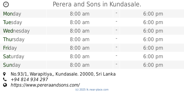
Perera and Sons
No.93/1, Warapitiya,, Kundasale.
Bakery
read more
727 m
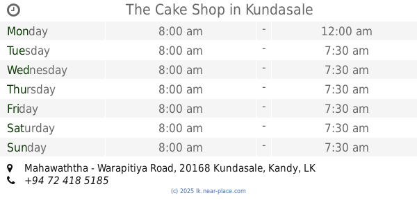
The Cake Shop
Mahawaththa - Warapitiya Road, Kundasale
Bakery
read more
1.966 km
Indika Super Center
Ampitiya
Bakery
read more
2.722 km
P & S Bakers
152 William Gopallawa Mawatha, Kandy
Bakery
read more
2.883 km
Ratna Bakery and Grocery Store
396, Ampitiya Road, Ampitiya
Bakery
read more
2.931 km
New Rathnayaka Bakers
Sri Lanka
Bakery
read more
3.618 km
Monako Bekers
Sirimalwatta
Bakery
read more
3.925 km
Layers
No. 5A, Mahamaya Mawatha, Kandy
Bakery
read more
4.144 km
Cakes.LK
Sangamitta Mawatha, Kandy
Bakery
read more
4.16 km
The Bread Shop
20000, Anagarika Dharmapala Mawatha, Kandy
Bakery
read more
4.276 km
Theldeniya Bakers
Balagolla
Bakery
read more
4.312 km
The Cake Shop Kandy
132/1, Temple Road, Haragama, Gurudeniya, Kandy
Bakery
read more
4.641 km
Dineth Bake House
Sri Lanka
Bakery
read more
4.663 km
Rambaken Bakery
Madawala - Rajawella Road, Menikhinna
Bakery
read more
5.017 km
Ratnayake Bakers
7 D S Senanayake Veediya, Kandy
Bakery
read more
5.087 km
Vasana Bakers
5 East L Senanayake Veediya, Kandy
Bakery
read more
5.099 km
Delight Sweet House (PVT) LTD
130 Colombo Street, Kandy
Bakery
read more
5.133 km
Delight Bakers & Sweet House (Pvt) Ltd
Sri Dalada Veediya, Kandy
Bakery
read more
5.275 km
Delight Cake and Bread Shop
100 Colombo Street, Kandy
Bakery
read more
5.324 km
Devon
Kandy
Bakery
read more
5.345 km
Sri Ramya Bakery
Cross Street, Kandy
Bakery
read more
5.361 km
Siri Ramya Hotel
Cross Street, Kandy
Bakery
read more
5.598 km
Singhe Stores
Teldeniya Road, Digana
Bakery
read more
5.79 km
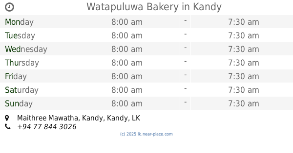
Watapuluwa Bakery
Maithree Mawatha, Kandy
Bakery
read more
📑
all categories
Accounting
Administrative area level 1
Administrative area level 2
Airport
Amusement park
Aquarium
Art gallery
Atm
Bakery
Bank
Bar
Beauty salon
Bicycle store
Book store
Bowling alley
Bus station
Cafe
Campground
Car dealer
Car rental
Car repair
Car wash
Casino
Cemetery
Church
City hall
Clothing store
Colloquial area
Convenience store
Country
Courthouse
Dentist
Department store
Doctor
Electrician
Electronics store
Embassy
Finance
Fire station
Florist
Food
Funeral home
Furniture store
Gas station
General contractor
Grocery or supermarket
Gym
Hair care
Hardware store
Health
Hindu Temple
Home goods store
Hospital
Insurance agency
Intersection
Jewelry store
Laundry
Lawyer
Library
Light rail station
Liquor store
Local government office
Locality
Locksmith
Lodging
Meal delivery
Meal takeaway
Mosque
Movie rental
Movie theater
Moving company
Museum
Natural feature
Neighborhood
Night club
Painter
Park
Parking
Pet store
Pharmacy
Physiotherapist
Place of worship
Plumber
Point of interest
Police
Political
Post office
Premise
Real estate agency
Restaurant
Roofing contractor
Route
Rv park, camping
School
Shoe store
Shopping mall
Spa
Stadium
Storage
Store
Subpremise
Supermarket
Synagogue
Taxi stand
Train station
Transit station
Travel agency
University
Veterinary care
Zoo
administrative area level 3
sublocality level 1
sublocality level 2
↑