Bakery nearby Ratnayake Bakers
Sri Lanka
Bakery nearby Ratnayake Bakers
Ratnayake Bakers
Katugastota, Sri Lanka
contacts phone
:
+94 812 215 774
Latitude:
7.3240036
, Longitude:
80.6253157
larger map & directions
read more
nearest Bakery
56 m
Rambakan Bakers
Katugastota
Bakery
read more
350 m
Orchid Bakers
Katugastota
Bakery
read more
742 m
Tikiri Bakers
Old matale Road, Kandy
Bakery
read more
958 m
Rathnayake Bakers රත්නායක බේකර්ස්
Kandy - Jaffna Highway, Kandy
Bakery
read more
1.032 km
Matale Bake House
Station Road, Katugastota
Bakery
read more
1.034 km
Millenium Bakery Mawilmada
Mawilmada Road, Kandy
Bakery
read more
1.169 km
Senuth Bread House
288a Colombo - Kandy Road, Katugasthota
Bakery
read more
1.707 km
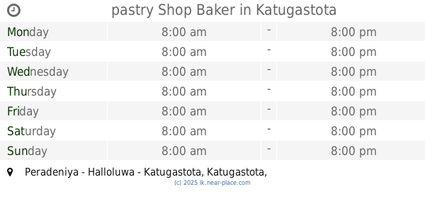
pastry Shop Baker
Peradeniya - Halloluwa - Katugastota, Katugastota
Bakery
read more
1.75 km
Senola Bakery
4a Madawala Rd katugasthota, katugasthota
Bakery
read more
2.236 km
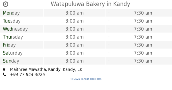
Watapuluwa Bakery
Maithree Mawatha, Kandy
Bakery
read more
2.808 km
Candy Corner Distributors & Bakery
Wariyapola Sri Sumangala Mawatha, Kandy
Bakery
read more
3.334 km
Devon
Kandy
Bakery
read more
3.486 km
Delight Cake and Bread Shop
100 Colombo Street, Kandy
Bakery
read more
3.522 km
Kandurata Bakehouse
Sri Lanka
Bakery
read more
3.522 km
Kandurata Bakehouse
Udathalawinna
Bakery
read more
3.558 km
Lanka Bake House
Kandy
Bakery
read more
3.568 km
Delight Sweet House (PVT) LTD
130 Colombo Street, Kandy
Bakery
read more
3.662 km
Vasana Bakers
5 East L Senanayake Veediya, Kandy
Bakery
read more
4.021 km
Vijayan’s cake
Kandy
Bakery
read more
4.113 km
Cakes.LK
Sangamitta Mawatha, Kandy
Bakery
read more
4.447 km
Bread & Bakers
Matale Road, Akurana
Bakery
read more
4.556 km
Isuru Bakers
Yatihalagala Road, Halloluwa
Bakery
read more
4.634 km
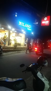
Milano Bakers
Akurana
Bakery
read more
4.752 km
Kapila Bakers & Sweet House
Warathenna, Halloluwa, Peradeniya
Bakery
read more
5.25 km
New Rathnayaka Bakers
Sri Lanka
Bakery
read more
📑
all categories
Accounting
Administrative area level 1
Administrative area level 2
Airport
Amusement park
Aquarium
Art gallery
Atm
Bakery
Bank
Bar
Beauty salon
Bicycle store
Book store
Bowling alley
Bus station
Cafe
Campground
Car dealer
Car rental
Car repair
Car wash
Casino
Cemetery
Church
City hall
Clothing store
Colloquial area
Convenience store
Country
Courthouse
Dentist
Department store
Doctor
Electrician
Electronics store
Embassy
Finance
Fire station
Florist
Food
Funeral home
Furniture store
Gas station
General contractor
Grocery or supermarket
Gym
Hair care
Hardware store
Health
Hindu Temple
Home goods store
Hospital
Insurance agency
Intersection
Jewelry store
Laundry
Lawyer
Library
Light rail station
Liquor store
Local government office
Locality
Locksmith
Lodging
Meal delivery
Meal takeaway
Mosque
Movie rental
Movie theater
Moving company
Museum
Natural feature
Neighborhood
Night club
Painter
Park
Parking
Pet store
Pharmacy
Physiotherapist
Place of worship
Plumber
Point of interest
Police
Political
Post office
Premise
Real estate agency
Restaurant
Roofing contractor
Route
Rv park, camping
School
Shoe store
Shopping mall
Spa
Stadium
Storage
Store
Subpremise
Supermarket
Synagogue
Taxi stand
Train station
Transit station
Travel agency
University
Veterinary care
Zoo
administrative area level 3
sublocality level 1
sublocality level 2
↑