Bakery nearby Sham Bakers
Sri Lanka
Bakery nearby Sham Bakers
Sham Bakers
Veluwana Road, 00900, Colombo, Colombo, LK Sri Lanka
contacts phone
:
+94
Latitude:
6.929601
, Longitude:
79.8795729
larger map & directions
read more
nearest Bakery
447 m
Nandasiri Bakers
Maligawatta East, Colombo
Bakery
read more
508 m
Sirimayura Bakers
Sri Nigrodharama Mawatha, Colombo
Bakery
read more
769 m
New Manel Bakers
Sri Dhamma Mawatha, Colombo
Bakery
read more
863 m
Kusum Cafe
Colombo
Bakery
read more
982 m
Minan Bake House
316 North M. Ishak Mawatha, Colombo
Bakery
read more
1.008 km
Masha Bakers
101 Maligawatte Road, Colombo
Bakery
read more
1.094 km
Maligawatta Bake House
Colombo
Bakery
read more
1.292 km
Mahinda Bakers
12 Magazine Road, Colombo
Bakery
read more
1.292 km
Mahinda Bakers
Sri Lanka
Bakery
read more
1.316 km
panda cake city
765/27B Sri Bodhiraja Mawatha, Colombo
Bakery
read more
1.33 km
Cannys Bakers
P. de S. Kaluratne Mw., Colombo
Bakery
read more
1.334 km
Wish Bakers
2/1 Temple Road, Colombo
Bakery
read more
1.346 km
P & S
839 Maradana Road, Colombo
Bakery
read more
1.35 km
House of Culinary Art
105, Sri Vajiragnana Mawatha, Colombo
Bakery
read more
1.457 km
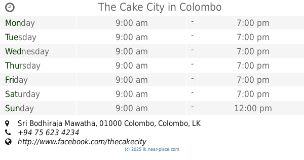
The Cake City
B18, Bodhiraja Mawatha, Colombo-10, Sri Bodhiraja Mawatha, Colombo
Bakery
read more
1.463 km
Don's Bakers
84/D, Baseline Road, Colombo
Bakery
read more
1.603 km
Royal Hotel & Bakers
Sri Lanka
Bakery
read more
1.604 km
Ricorn Hotel & Bakers
Colombo
Bakery
read more
1.605 km
Dayarathna Bakery
Pirivena Road, Sri Jayawardenepura Kotte
Bakery
read more
1.906 km
Cuties Cupcake
Awwal Zavia Road, Colombo
Bakery
read more
2.059 km
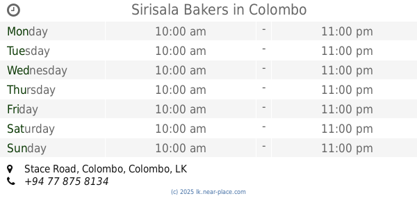
Sirisala Bakers
Stace Road, Colombo
Bakery
read more
2.075 km
Testa Bake House
Ven Baddegama Wimalawansa Mawatha, Colombo
Bakery
read more
2.078 km
Delicious Delight
Welewatta
Bakery
read more
2.084 km
Lanka Bake House
Aluthkade East, Colombo
Bakery
read more
2.182 km
Anthony's Pastry Shop
Colombo
Bakery
read more
📑
all categories
Accounting
Administrative area level 1
Administrative area level 2
Airport
Amusement park
Aquarium
Art gallery
Atm
Bakery
Bank
Bar
Beauty salon
Bicycle store
Book store
Bowling alley
Bus station
Cafe
Campground
Car dealer
Car rental
Car repair
Car wash
Casino
Cemetery
Church
City hall
Clothing store
Colloquial area
Convenience store
Country
Courthouse
Dentist
Department store
Doctor
Electrician
Electronics store
Embassy
Finance
Fire station
Florist
Food
Funeral home
Furniture store
Gas station
General contractor
Grocery or supermarket
Gym
Hair care
Hardware store
Health
Hindu Temple
Home goods store
Hospital
Insurance agency
Intersection
Jewelry store
Laundry
Lawyer
Library
Light rail station
Liquor store
Local government office
Locality
Locksmith
Lodging
Meal delivery
Meal takeaway
Mosque
Movie rental
Movie theater
Moving company
Museum
Natural feature
Neighborhood
Night club
Painter
Park
Parking
Pet store
Pharmacy
Physiotherapist
Place of worship
Plumber
Point of interest
Police
Political
Post office
Premise
Real estate agency
Restaurant
Roofing contractor
Route
Rv park, camping
School
Shoe store
Shopping mall
Spa
Stadium
Storage
Store
Subpremise
Supermarket
Synagogue
Taxi stand
Train station
Transit station
Travel agency
University
Veterinary care
Zoo
administrative area level 3
sublocality level 1
sublocality level 2
↑