Bakery nearby Sugar Dreams Cake Shop
Sri Lanka
Bakery nearby Sugar Dreams Cake Shop
Sugar Dreams Cake Shop
Mulleriyawa South, Sri Lanka
contacts phone
:
+94 112 569 845
Latitude:
6.935337
, Longitude:
79.932132
larger map & directions
read more
nearest Bakery
9 m
Richluck Cakes
Mulleriyawa, South
Bakery
read more
720 m
Dishy Bakers
Belagama, Angoda
Bakery
read more
811 m
CakeQ
325, Himbutana Road, Angoda
Bakery
read more
1.018 km
Ranrose Bakers
204, old abathale road, mulleriyawa north Angoda
Bakery
read more
1.099 km
Silver Treats
Rukattana Gahawatta Dr, Kotikawatta
Bakery
read more
1.218 km
Pahansilu Bakers
Himbutana East
Bakery
read more
1.495 km
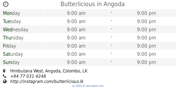
Butterlicious
Himbutana West
Bakery
read more
1.611 km
Victory Bakery
Sri Lanka
Bakery
read more
1.729 km
Remarko Bakers
Kotikawatta East
Bakery
read more
1.796 km
Janahitha Bakers
Sri Lanka
Bakery
read more
1.805 km
Bakes By Kithi
Sri Lanka
Bakery
read more
2.001 km
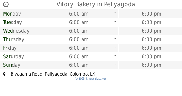
Vitory Bakery
Biyagama Road, Peliyagoda
Bakery
read more
2.233 km
Home Bakes
464/5, Rajasinghe Mawatha, Salmal Uyana, Himbutana
Bakery
read more
2.302 km
Tanuja Bakery
Peliyagoda
Bakery
read more
2.308 km
Dhanushka Bakery
Aggona Junction, Kalapaluwawa Road, Kolonnawa
Bakery
read more
2.336 km
Sweets & Treats
213, Gonawala Road, Kelaniya
Bakery
read more
2.384 km
Perera and Sons
B214, Peliyagoda
Bakery
read more
2.4 km
Premalal Stores
Maha Buthgamuwa C
Bakery
read more
2.463 km
Wish Bakers
Sri Lanka
Bakery
read more
2.502 km
Bread and Bun Bakery
Kalapaluwawa Road
Bakery
read more
2.529 km
Don's Bakers & Restaurant
910 A Biyagama Road, Peliyagoda
Bakery
read more
2.693 km
Remarko
Kelaniya
Bakery
read more
2.715 km
Victory Bakery
183/3 Biyagama Road, Peliyagoda
Bakery
read more
3.113 km
Ishan Bakers
Rajagiriya
Bakery
read more
3.57 km
Paragon Bakery and Shop
Nungamugoda Road, Peliyagoda
Bakery
read more
📑
all categories
Accounting
Administrative area level 1
Administrative area level 2
Airport
Amusement park
Aquarium
Art gallery
Atm
Bakery
Bank
Bar
Beauty salon
Bicycle store
Book store
Bowling alley
Bus station
Cafe
Campground
Car dealer
Car rental
Car repair
Car wash
Casino
Cemetery
Church
City hall
Clothing store
Colloquial area
Convenience store
Country
Courthouse
Dentist
Department store
Doctor
Electrician
Electronics store
Embassy
Finance
Fire station
Florist
Food
Funeral home
Furniture store
Gas station
General contractor
Grocery or supermarket
Gym
Hair care
Hardware store
Health
Hindu Temple
Home goods store
Hospital
Insurance agency
Intersection
Jewelry store
Laundry
Lawyer
Library
Light rail station
Liquor store
Local government office
Locality
Locksmith
Lodging
Meal delivery
Meal takeaway
Mosque
Movie rental
Movie theater
Moving company
Museum
Natural feature
Neighborhood
Night club
Painter
Park
Parking
Pet store
Pharmacy
Physiotherapist
Place of worship
Plumber
Point of interest
Police
Political
Post office
Premise
Real estate agency
Restaurant
Roofing contractor
Route
Rv park, camping
School
Shoe store
Shopping mall
Spa
Stadium
Storage
Store
Subpremise
Supermarket
Synagogue
Taxi stand
Train station
Transit station
Travel agency
University
Veterinary care
Zoo
administrative area level 3
sublocality level 1
sublocality level 2
↑