Bakery nearby Super Food Corner
Sri Lanka
Bakery nearby Super Food Corner
Super Food Corner
Yatawatta Sri Lanka
contacts phone
:
+94
Latitude:
7.5630225
, Longitude:
80.5885373
read more
nearest Bakery
168 m
Garman Bake House
no 8/1,dangan place,yatawatta ,matale,sri lanka, matale
Bakery
read more
328 m
Wasana Bake House
Yatawatta
Bakery
read more
1.206 km
Ahmad Bake House
Matale
Bakery
read more
5.467 km
New Akurana Bake House
Sri Lanka
Bakery
read more
5.55 km
Chinthaka Shop
Pallekahahena Road
Bakery
read more
7.389 km
Sumanasiri Bakers & Stores
Sri Lanka
Bakery
read more
7.971 km
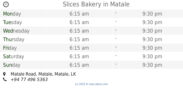
Slices Bakery
Matale Road, Matale
Bakery
read more
9.905 km
Sampath Hotel and Bake House
Matale
Bakery
read more
10.559 km
Vinro Bakers
99/A Kings St, Matale
Bakery
read more
10.849 km
Ratnayaka Bakers
Matale
Bakery
read more
10.86 km
Masha Bake House
78 Main Street, Rattota
Bakery
read more
10.877 km
Wasana Bakers
Matale
Bakery
read more
10.938 km
Upland Bakers
No. 7E, Rose Street, Matale
Bakery
read more
11.145 km
Ratnayake Bakers
82 Dharmapala Mawatha, Matale
Bakery
read more
11.193 km
Haira Farm House
93 Gangawela Road, Matale
Bakery
read more
11.616 km
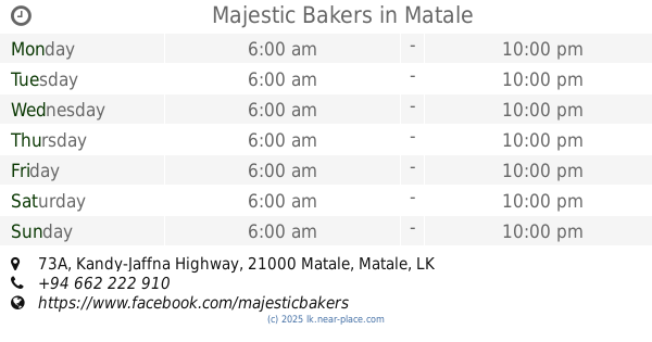
Majestic Bakers
73A Kandy-Jaffna Highway, Matale
Bakery
read more
11.655 km
New Kandy Bake House
Matale
Bakery
read more
11.691 km
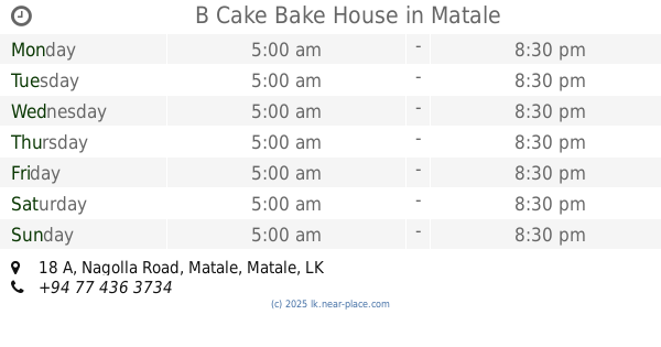
B Cake Bake House
18 A Nagolla Road, Matale
Bakery
read more
12.302 km
MCAKE HOUSE
Matale
Bakery
read more
12.484 km
Pandivita Hotel
AB26, Matale
Bakery
read more
12.92 km
Little Star Bakers
No. 200,, Polgolla,, Gokarella., Ibbaganuwa
Bakery
read more
13.851 km
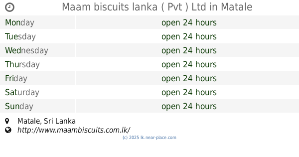
Maam biscuits lanka ( Pvt ) Ltd
Matale
Bakery
read more
14.534 km
Thilini Bakers (Pvt) Ltd
Ankumbura
Bakery
read more
16.538 km
Fine Tesco Bake House
Ukuwela
Bakery
read more
17.569 km
Mihiri Bakery & Hotel
Kandy - Jaffna Highway, Naula
Bakery
read more
📑
all categories
Accounting
Administrative area level 1
Administrative area level 2
Airport
Amusement park
Aquarium
Art gallery
Atm
Bakery
Bank
Bar
Beauty salon
Bicycle store
Book store
Bowling alley
Bus station
Cafe
Campground
Car dealer
Car rental
Car repair
Car wash
Casino
Cemetery
Church
City hall
Clothing store
Colloquial area
Convenience store
Country
Courthouse
Dentist
Department store
Doctor
Electrician
Electronics store
Embassy
Finance
Fire station
Florist
Food
Funeral home
Furniture store
Gas station
General contractor
Grocery or supermarket
Gym
Hair care
Hardware store
Health
Hindu Temple
Home goods store
Hospital
Insurance agency
Intersection
Jewelry store
Laundry
Lawyer
Library
Light rail station
Liquor store
Local government office
Locality
Locksmith
Lodging
Meal delivery
Meal takeaway
Mosque
Movie rental
Movie theater
Moving company
Museum
Natural feature
Neighborhood
Night club
Painter
Park
Parking
Pet store
Pharmacy
Physiotherapist
Place of worship
Plumber
Point of interest
Police
Political
Post office
Premise
Real estate agency
Restaurant
Roofing contractor
Route
Rv park, camping
School
Shoe store
Shopping mall
Spa
Stadium
Storage
Store
Subpremise
Supermarket
Synagogue
Taxi stand
Train station
Transit station
Travel agency
University
Veterinary care
Zoo
administrative area level 3
sublocality level 1
sublocality level 2
↑