Bakery nearby The Cake Factory
Sri Lanka
Bakery nearby The Cake Factory
The Cake Factory
91A, 5th Lane, 00300, Colombo, Colombo, LK Sri Lanka
contacts phone
:
+94 112 372 322
website:
www.cakefactory.lk
Latitude:
6.905273
, Longitude:
79.8563848
larger map & directions
read more
nearest Bakery
224 m
Cakes By Fio
Colombo
Bakery
read more
289 m
Susiko Bakery
Colombo
Bakery
read more
289 m
Susiko Bakers
Thurstan Swimming pool, Thurstan Road, Colombo
Bakery
read more
383 m
Perera & Sons
24 Deal Place, Colombo
Bakery
read more
494 m
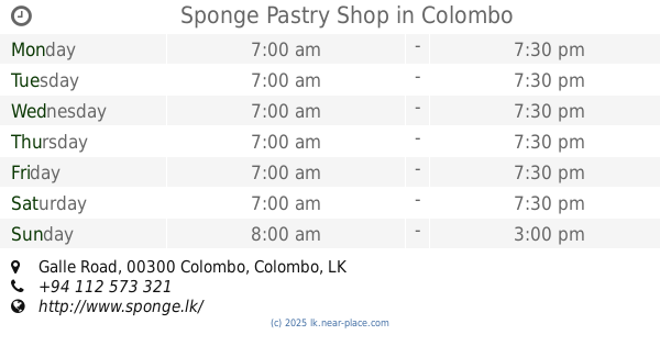
Sponge Pastry Shop
347, Galle Road, Colombo
Bakery
read more
494 m
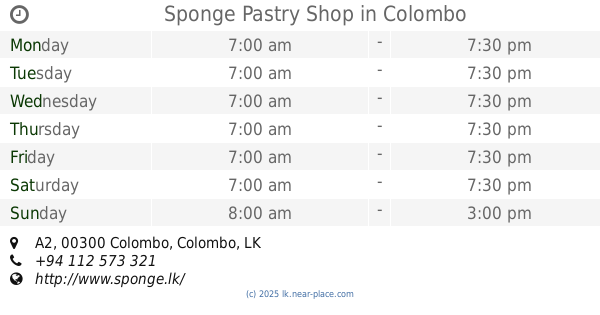
Sponge Pastry Shop
347, A2, Colombo
Bakery
read more
724 m
Paan Paan
6B Alfred House Gardens Road
Bakery
read more
726 m
Divine Cakes
Queen's Road, Colombo
Bakery
read more
751 m
Chameera Snack Bar
Colombo
Bakery
read more
759 m
Paan Paan
6B Alfred House Gardens Road, Colombo
Bakery
read more
836 m
Ideal Cakes by Shaheema Fowzan
Colombo
Bakery
read more
843 m
Green Cabin Terrace
453 Galle Road, Colombo
Bakery
read more
895 m
Gillos
36 Temple Lane, Colombo
Bakery
read more
959 m
THE CAKE
Boyd Place, Colombo
Bakery
read more
969 m
A&M Cupcakes
469 A2, Colombo
Bakery
read more
969 m
A&M Cupcakes
469 Galle Rd, Colombo
Bakery
read more
969 m
Little Miss
469 Galle Rd, Colombo
Bakery
read more
999 m
Perera & Sons
2, Dharmapala Mawatha,, Colombo 03
Bakery
read more
1.12 km
Ruwan Bakers
Kollupitiya, Colombo
Bakery
read more
1.206 km
Asian Bakery @ 52
00300,, Hudson Road, Colombo
Bakery
read more
1.296 km
Caravan Fresh - The cake and pastry shop
Alexandra Roundabout, Colombo
Bakery
read more
1.363 km
Paan Paan
98 Sri Sambuddhathva Jayanthi Mawatha, Colombo
Bakery
read more
1.62 km
Perera and Sons
Vajira Road, Colombo
Bakery
read more
1.713 km
Testa Bake House
Ven Baddegama Wimalawansa Mawatha, Colombo
Bakery
read more
2.434 km
P & S
839 Maradana Road, Colombo
Bakery
read more
📑
all categories
Accounting
Administrative area level 1
Administrative area level 2
Airport
Amusement park
Aquarium
Art gallery
Atm
Bakery
Bank
Bar
Beauty salon
Bicycle store
Book store
Bowling alley
Bus station
Cafe
Campground
Car dealer
Car rental
Car repair
Car wash
Casino
Cemetery
Church
City hall
Clothing store
Colloquial area
Convenience store
Country
Courthouse
Dentist
Department store
Doctor
Electrician
Electronics store
Embassy
Finance
Fire station
Florist
Food
Funeral home
Furniture store
Gas station
General contractor
Grocery or supermarket
Gym
Hair care
Hardware store
Health
Hindu Temple
Home goods store
Hospital
Insurance agency
Intersection
Jewelry store
Laundry
Lawyer
Library
Light rail station
Liquor store
Local government office
Locality
Locksmith
Lodging
Meal delivery
Meal takeaway
Mosque
Movie rental
Movie theater
Moving company
Museum
Natural feature
Neighborhood
Night club
Painter
Park
Parking
Pet store
Pharmacy
Physiotherapist
Place of worship
Plumber
Point of interest
Police
Political
Post office
Premise
Real estate agency
Restaurant
Roofing contractor
Route
Rv park, camping
School
Shoe store
Shopping mall
Spa
Stadium
Storage
Store
Subpremise
Supermarket
Synagogue
Taxi stand
Train station
Transit station
Travel agency
University
Veterinary care
Zoo
administrative area level 3
sublocality level 1
sublocality level 2
↑