Bank nearby People's Bank
Sri Lanka
Bank nearby People's Bank
People's Bank
AB16, Chunnakam, Jaffna, LK Sri Lanka
contacts phone
:
+94 212 242 323
website:
www.peoplesbank.lk
Latitude:
9.7449336
, Longitude:
80.0276358
larger map & directions
read more
nearest Bank
62 m
Pan Asia Bank
N021, Jaffna-Kankesanturai Road, Chunnakam
Bank
read more
117 m
Hatton National Bank PLC
Jaffna-Kankesanturai Road, Chunnakam
Bank
read more
133 m
Pan Asia Bank
Chunnakam
Bank
read more
168 m
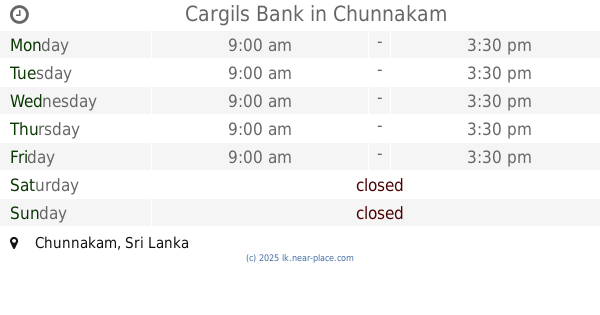
Cargils Bank
Chunnakam
Bank
read more
171 m
Commercial Bank Chunnakam Branch கொமர்ஷல் வங்கி சுன்னாகம்
Rajah Complex, No 87 K K S Road,, Chunnakam
Bank
read more
241 m
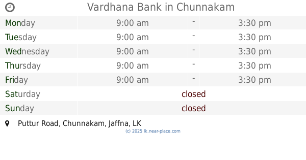
Vardhana Bank
Puttur Road, Chunnakam
Bank
read more
256 m
SDB Bank
Chunnakam
Bank
read more
260 m
Seylan Bank Chunnakam
Jaffna-Kankesanturai Road, Chunnakam
Bank
read more
346 m
Bank of Ceylon - Chunnakam
146, Jaffna-Kankesanturai Road, Chunnakam
Bank
read more
346 m
Bank of Ceylon
146, Jaffna-Kankesanturai Road, Chunnakam
Bank
read more
347 m
Bank of Ceylon
146, KKS Road, Jaffna-Kankesanturai Road, Chunnakam
Bank
read more
413 m
Sampath Bank
AB16, Chunnakam
Bank
read more
461 m
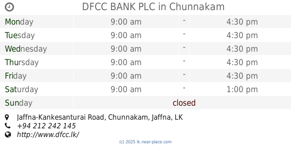
DFCC BANK PLC
122, Jaffna-Kankesanturai Road, Chunnakam
Bank
read more
510 m
National Saving Bank, Chunnakam
Chunnakam
Bank
read more
510 m
National Saving Bank
Chunnakam
Bank
read more
531 m
NSB Bank Next Lane
Chunnakam
Bank
read more
1.741 km
Bank of Ceylon
No51,K.K.S Road
Bank
read more
1.746 km
Bank of Ceylon - Kankesanturai
51, Jaffna-Kankesanturai Road
Bank
read more
1.834 km
Sanasa Development Bank
Jaffna-Kankesanturai Road, Jaffna
Bank
read more
2.554 km
People's Bank
Jaffna-Kankesanturai Road
Bank
read more
3.255 km
Peoples Bank Alaveddy
Alaveddy Road, Earlalai
Bank
read more
3.423 km
People's Bank, Urumpirai
AB18, Urumpirai North
Bank
read more
3.434 km
Bank of Ceylon - Urumpirai
Urumpirai South
Bank
read more
3.435 km
Bank of Ceylon
Urumpirai, AB18
Bank
read more
6.373 km
Bank of Ceylon Kopay
57, Ponitpedro Road , Kopay, Jaffna
Bank
read more
📑
all categories
Accounting
Administrative area level 1
Administrative area level 2
Airport
Amusement park
Aquarium
Art gallery
Atm
Bakery
Bank
Bar
Beauty salon
Bicycle store
Book store
Bowling alley
Bus station
Cafe
Campground
Car dealer
Car rental
Car repair
Car wash
Casino
Cemetery
Church
City hall
Clothing store
Colloquial area
Convenience store
Country
Courthouse
Dentist
Department store
Doctor
Electrician
Electronics store
Embassy
Finance
Fire station
Florist
Food
Funeral home
Furniture store
Gas station
General contractor
Grocery or supermarket
Gym
Hair care
Hardware store
Health
Hindu Temple
Home goods store
Hospital
Insurance agency
Intersection
Jewelry store
Laundry
Lawyer
Library
Light rail station
Liquor store
Local government office
Locality
Locksmith
Lodging
Meal delivery
Meal takeaway
Mosque
Movie rental
Movie theater
Moving company
Museum
Natural feature
Neighborhood
Night club
Painter
Park
Parking
Pet store
Pharmacy
Physiotherapist
Place of worship
Plumber
Point of interest
Police
Political
Post office
Premise
Real estate agency
Restaurant
Roofing contractor
Route
Rv park, camping
School
Shoe store
Shopping mall
Spa
Stadium
Storage
Store
Subpremise
Supermarket
Synagogue
Taxi stand
Train station
Transit station
Travel agency
University
Veterinary care
Zoo
administrative area level 3
sublocality level 1
sublocality level 2
↑