Bank nearby Peoples Bank
Sri Lanka
Bank nearby Peoples Bank
Peoples Bank
Kandy-Jaffna Highway, Kodikamam, Sri Lanka
contacts phone
:
+94 212 050 530
Latitude:
9.6814831
, Longitude:
80.2198065
larger map & directions
read more
nearest Bank
233 m
National Saving Bank (NSB)
Jaffna
Bank
read more
272 m
Hatton National Bank
Jaffna
Bank
read more
367 m
Commercial Bank Kodikamam Branch
Point Pedro Road, Kodikamam, AB31
Bank
read more
6.434 km
Seylan Bank & ATM
Chavakachcheri
Bank
read more
6.501 km
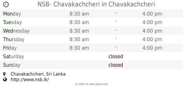
NSB- Chavakachcheri
Chavakachcheri
Bank
read more
6.919 km
Bank of Ceylon & ATM
A9, Chavakachcheri
Bank
read more
6.947 km
Commercial Credit
Chavakachcheri
Bank
read more
7.035 km
Nation Lanka Finance
Chavakachcheri
Bank
read more
13.323 km
Hatton National Bank PLC
Point Pedro Road, Nelliady
Bank
read more
13.35 km
National Development Bank
109, Jaffna Road,, Nelliady
Bank
read more
13.357 km
Seylan Bank
Karaveddi
Bank
read more
13.375 km
Sampath Bank, Nelliady
#169, Nelliady Jaffna Rd
Bank
read more
13.446 km
People's Bank
Karanthan Junction - Pon Selva Mahal, Chavakachcheri
Bank
read more
13.759 km
Bank of Ceylon - Nelliady
Kuncharkadai, AB20, Nelliady
Bank
read more
13.793 km
Bank of Ceylon - Manthikai
Manthikai Junction
Bank
read more
14.587 km
People's bank
A9 Rpad, Palai, Kandy - Jaffna Highway, Kilinochchi
Bank
read more
14.688 km
Bank of Ceylon
Siruppiddy
Bank
read more
15.178 km
Bimputh Finance PLC - Nelliady Branch
B438, Nelliady
Bank
read more
15.178 km
Bimputh Finance PLC - Nelliady Branch
Vallai-Uduppiddi-Valvedditturai Road, Nelliady
Bank
read more
15.664 km
Commercial Bank Achchuvely Branch
No 13, Raja Veethy, Achchuvely
Bank
read more
15.672 km
Bank of Ceylon - Atchuvely
B437
Bank
read more
15.672 km
Bank of Ceylon - Atchuvely
Vallai-Tellippalai-Araly Road
Bank
read more
15.676 km
Bank of Ceylon
B33
Bank
read more
15.695 km
Hatton National Bank PLC
B33
Bank
read more
15.738 km
union bank
Avarankal-Tondaimanar Road
Bank
read more
📑
all categories
Accounting
Administrative area level 1
Administrative area level 2
Airport
Amusement park
Aquarium
Art gallery
Atm
Bakery
Bank
Bar
Beauty salon
Bicycle store
Book store
Bowling alley
Bus station
Cafe
Campground
Car dealer
Car rental
Car repair
Car wash
Casino
Cemetery
Church
City hall
Clothing store
Colloquial area
Convenience store
Country
Courthouse
Dentist
Department store
Doctor
Electrician
Electronics store
Embassy
Finance
Fire station
Florist
Food
Funeral home
Furniture store
Gas station
General contractor
Grocery or supermarket
Gym
Hair care
Hardware store
Health
Hindu Temple
Home goods store
Hospital
Insurance agency
Intersection
Jewelry store
Laundry
Lawyer
Library
Light rail station
Liquor store
Local government office
Locality
Locksmith
Lodging
Meal delivery
Meal takeaway
Mosque
Movie rental
Movie theater
Moving company
Museum
Natural feature
Neighborhood
Night club
Painter
Park
Parking
Pet store
Pharmacy
Physiotherapist
Place of worship
Plumber
Point of interest
Police
Political
Post office
Premise
Real estate agency
Restaurant
Roofing contractor
Route
Rv park, camping
School
Shoe store
Shopping mall
Spa
Stadium
Storage
Store
Subpremise
Supermarket
Synagogue
Taxi stand
Train station
Transit station
Travel agency
University
Veterinary care
Zoo
administrative area level 3
sublocality level 1
sublocality level 2
↑