Bank nearby Sampath Bank Ragama
Sri Lanka
Bank nearby Sampath Bank Ragama
Sampath Bank Ragama
Ragama, Sri Lanka
contacts phone
:
+94 112 960 659
website:
www.sampath.lk
Latitude:
7.0270976
, Longitude:
79.9247583
larger map & directions
read more
nearest Bank
46 m
Commercial Bank - Ragama
No 51, Kadawatha Road, Ragama
Bank
read more
207 m
National Savings Bank
B13, Ragama
Bank
read more
215 m
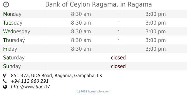
Bank of Ceylon Ragama.
851.37a UDA Road, Ragama
Bank
read more
222 m
Bank of Ceylon
Ragama
Bank
read more
225 m
CDB Finance PLC
851.37a UDA Road, Ragama
Bank
read more
231 m
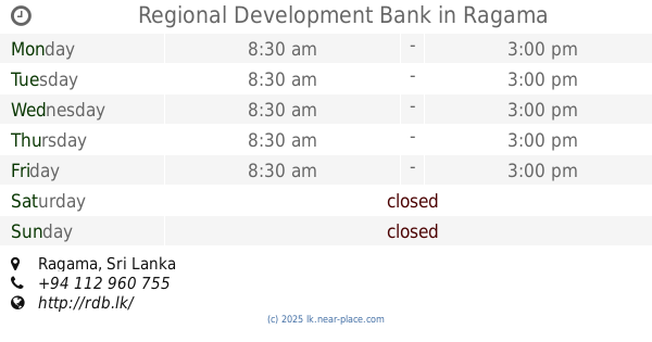
Regional Development Bank
Ragama
Bank
read more
238 m
People's Bank Ragama
Ragama
Bank
read more
265 m
Cooperative Rural Bank & Pawning center
Ragama
Bank
read more
477 m
Hatton National Bank
Thewatta Road, Ragama
Bank
read more
1.169 km
CRB Bank
Ragama
Bank
read more
1.843 km
Sampath Bank - ATM
B13, Ragama
Bank
read more
2.131 km
People Leasing & Finance Plc
Ragama
Bank
read more
2.807 km
Sanasa Development Bank සණස සංවර්ධන බැංකුව
Negombo Road, Welisara
Bank
read more
2.807 km
Sanasa Development Bank සණස සංවර්ධන බැංකුව
511 Negambo Road, Wattala
Bank
read more
3.032 km
Co-Operative Rural Bnak - Welisara
Ryan Suba home, 197c Nagoda Church Road, Kandana
Bank
read more
3.107 km
Kirimatiyagara Rural Bank - CRB
Kadawatha
Bank
read more
3.148 km
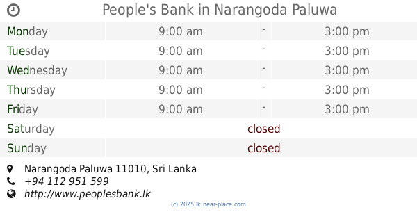
People's Bank
Narangoda Paluwa
Bank
read more
3.394 km
Sanasa Society Batuwatta
Ragama Batuwatta Road, Batuwatta
Bank
read more
3.746 km
NDDCB
119 / 2 / B / 1, B13, Kadawatha
Bank
read more
3.947 km
Sampath Bank
174/3 Ragama Road, Kadawatha
Bank
read more
3.972 km
Bank of Ceylon, Super Grade Branch, Kadawatha
Kadawatha
Bank
read more
3.972 km
Bank of Ceylon
Kadawatha
Bank
read more
3.982 km
DFCC Bank
No.341, Kandy Road, Kadawatha
Bank
read more
4.004 km
Nations Trust Bank
144/1A, Sumitomo Building, Kandy Road, Kadawatha
Bank
read more
4.016 km
Hatton National Bank
A1, Kadawatha
Bank
read more
📑
all categories
Accounting
Administrative area level 1
Administrative area level 2
Airport
Amusement park
Aquarium
Art gallery
Atm
Bakery
Bank
Bar
Beauty salon
Bicycle store
Book store
Bowling alley
Bus station
Cafe
Campground
Car dealer
Car rental
Car repair
Car wash
Casino
Cemetery
Church
City hall
Clothing store
Colloquial area
Convenience store
Country
Courthouse
Dentist
Department store
Doctor
Electrician
Electronics store
Embassy
Finance
Fire station
Florist
Food
Funeral home
Furniture store
Gas station
General contractor
Grocery or supermarket
Gym
Hair care
Hardware store
Health
Hindu Temple
Home goods store
Hospital
Insurance agency
Intersection
Jewelry store
Laundry
Lawyer
Library
Light rail station
Liquor store
Local government office
Locality
Locksmith
Lodging
Meal delivery
Meal takeaway
Mosque
Movie rental
Movie theater
Moving company
Museum
Natural feature
Neighborhood
Night club
Painter
Park
Parking
Pet store
Pharmacy
Physiotherapist
Place of worship
Plumber
Point of interest
Police
Political
Post office
Premise
Real estate agency
Restaurant
Roofing contractor
Route
Rv park, camping
School
Shoe store
Shopping mall
Spa
Stadium
Storage
Store
Subpremise
Supermarket
Synagogue
Taxi stand
Train station
Transit station
Travel agency
University
Veterinary care
Zoo
administrative area level 3
sublocality level 1
sublocality level 2
↑