Bank nearby Samurdhi Bank
Sri Lanka
Bank nearby Samurdhi Bank
Samurdhi Bank
Batuwatta, Sri Lanka
contacts phone
:
+94
Latitude:
7.0590612
, Longitude:
79.9302437
larger map & directions
read more
nearest Bank
5 m
Divi Naguma Prajamuula Bank
Ragama Batuwatta Road, Batuwatta
Bank
read more
652 m
Co-operative Bank - Batuwatta
Ragama Kadana Road, Ja-Ela
Bank
read more
1.002 km
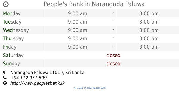
People's Bank
Narangoda Paluwa
Bank
read more
1.03 km
Sanasa Bank
Ja-Ela
Bank
read more
1.45 km
Sanasa Society Batuwatta
Ragama Batuwatta Road, Batuwatta
Bank
read more
1.457 km
sanasa bollatha
Ja-Ela
Bank
read more
2.087 km
Cooperative Rural Bank
Ja-ela - Ganemulla Road, Ja-Ela
Bank
read more
2.322 km
People Leasing & Finance Plc
Ragama
Bank
read more
2.429 km
Rural Bank
Galahitiyawa South, Ganemulla
Bank
read more
3.01 km
Sanasa Bank
242/A, Ja-Ela
Bank
read more
3.448 km
Thibbatugoda Graamiya Bank (තිබ්බ්ටුගොඩ ගරාමීය බැන්කුව
Thibbatugoda Purana Viharaya, Ganemulla
Bank
read more
3.577 km
National Savings Bank
B13, Ragama
Bank
read more
3.601 km
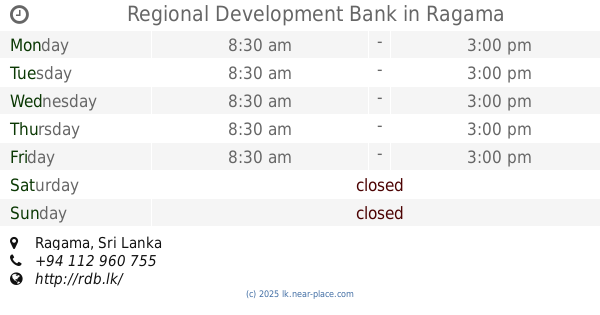
Regional Development Bank
Ragama
Bank
read more
3.61 km
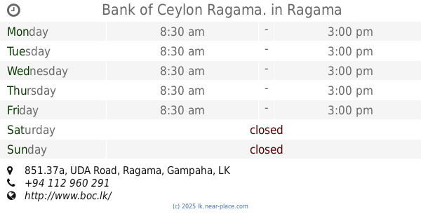
Bank of Ceylon Ragama.
851.37a UDA Road, Ragama
Bank
read more
3.686 km
Rural Bank
Kadawatha - Ganemulla Road, Kadawatha
Bank
read more
3.764 km
Sanasa Bank
Kadawatha
Bank
read more
3.894 km
Commercial Bank Kandana Branch
No 41D, Negombo Road, Kandana
Bank
read more
3.899 km
Cdb Bank Kandana
67d Negombo-Colombo Main Road, Kandana
Bank
read more
4.592 km
Sampath Bank
No.165, Realty Plaza, Negombo Road, Ja-Ela
Bank
read more
4.61 km
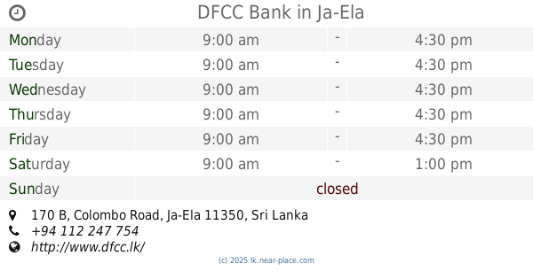
DFCC Bank
170 B, Colombo Road, Ja-Ela
Bank
read more
4.613 km
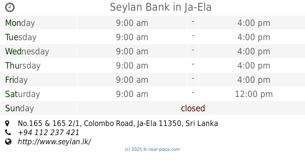
Seylan Bank
No.165 & 165 2/1, Colombo Road, Ja-Ela
Bank
read more
4.699 km
Union Bank
151/B, Colombo Road, Ja-Ela
Bank
read more
5.016 km
National Savings Bank
134, C 113 , Negombo Road, Ja-Ela
Bank
read more
5.291 km
Sanasa Development Bank සණස සංවර්ධන බැංකුව
511 Negambo Road, Wattala
Bank
read more
5.736 km
Samurdhi Bank
Josita Watta
Bank
read more
📑
all categories
Accounting
Administrative area level 1
Administrative area level 2
Airport
Amusement park
Aquarium
Art gallery
Atm
Bakery
Bank
Bar
Beauty salon
Bicycle store
Book store
Bowling alley
Bus station
Cafe
Campground
Car dealer
Car rental
Car repair
Car wash
Casino
Cemetery
Church
City hall
Clothing store
Colloquial area
Convenience store
Country
Courthouse
Dentist
Department store
Doctor
Electrician
Electronics store
Embassy
Finance
Fire station
Florist
Food
Funeral home
Furniture store
Gas station
General contractor
Grocery or supermarket
Gym
Hair care
Hardware store
Health
Hindu Temple
Home goods store
Hospital
Insurance agency
Intersection
Jewelry store
Laundry
Lawyer
Library
Light rail station
Liquor store
Local government office
Locality
Locksmith
Lodging
Meal delivery
Meal takeaway
Mosque
Movie rental
Movie theater
Moving company
Museum
Natural feature
Neighborhood
Night club
Painter
Park
Parking
Pet store
Pharmacy
Physiotherapist
Place of worship
Plumber
Point of interest
Police
Political
Post office
Premise
Real estate agency
Restaurant
Roofing contractor
Route
Rv park, camping
School
Shoe store
Shopping mall
Spa
Stadium
Storage
Store
Subpremise
Supermarket
Synagogue
Taxi stand
Train station
Transit station
Travel agency
University
Veterinary care
Zoo
administrative area level 3
sublocality level 1
sublocality level 2
↑