Bar nearby Chabot Wine Store
Sri Lanka
Bar nearby Chabot Wine Store
Chabot Wine Store
Kandy Road, Nawalapitiya, Kandy, LK Sri Lanka
contacts phone
:
+94
Latitude:
7.0554726
, Longitude:
80.5341759
larger map & directions
read more
nearest Bar
7.8 km
Kotmala Oya Liquor Restaurant
Gangaihala Korale
Bar
read more
8.515 km
Chamara Wine Store
B319, ගිනිගත්හේන
Bar
read more
8.515 km
Chamara Wine Store
B319, Ginigathhena
Bar
read more
8.574 km
Ginigathhena Wine Stores
Ginigathhena
Bar
read more
8.68 km
Jayantha Resturant & Bar
Ginigathhena
Bar
read more
8.751 km
Milanium Restaurant
Ginigathhena
Bar
read more
11.068 km
Villa Magnolia
Nuwara Eliya
Bar
read more
12.369 km
Thilanka Wine Stores
Gampola
Bar
read more
12.38 km
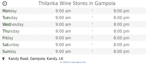
Thilanka Wine Stores
Kandy Road, Gampola
Bar
read more
12.621 km
Rukman Restaurant
Gampola
Bar
read more
12.696 km
Janatha Wine Stores
Gampola
Bar
read more
19.498 km
Frank Land Hotel And Bar
Hatton - Maskeliya - Dalhousie Road, Hatton
Bar
read more
19.639 km
Laa Adams
No :10, Mendis Mawatha, Hatton
Bar
read more
19.71 km
Samanpura Wine Stores
samanpura wine stores no 09 main street hatton
Bar
read more
19.727 km
Malelne Wine
Hatton
Bar
read more
21.569 km
Lucky Wine Stores
18, Peradeniya-Deltota-Rikiligaskada Road, Galaha
Bar
read more
24.031 km
Kuruppuarachchi Wine Stores
A1
Bar
read more
24.974 km
MACHAN PERADENIYA
No 08 Dangolla Road, Kandy
Bar
read more
25.051 km
MACHAN PERADENIYA
Sri Amarawansa Mawatha, Kandy
Bar
read more
25.65 km
Tavern 29 Rooftop Bar
11, Deveni Rajasinghe Mawatha, Kandy
Bar
read more
26.431 km
Nanuoya Restaurant & Bar
No. 52, Avissawella-Hatton-Nuwara Eliya Highway, Nanuoya
Bar
read more
27.95 km
Asiri Wine Store
Karandupana
Bar
read more
29.486 km
Diamond Wine Stores
A26, Nattarampota
Bar
read more
30.549 km
Oriental Vine Store
Kegalle
Bar
read more
31.244 km
Millenium Bar
Kegalle
Bar
read more
📑
all categories
Accounting
Administrative area level 1
Administrative area level 2
Airport
Amusement park
Aquarium
Art gallery
Atm
Bakery
Bank
Bar
Beauty salon
Bicycle store
Book store
Bowling alley
Bus station
Cafe
Campground
Car dealer
Car rental
Car repair
Car wash
Casino
Cemetery
Church
City hall
Clothing store
Colloquial area
Convenience store
Country
Courthouse
Dentist
Department store
Doctor
Electrician
Electronics store
Embassy
Finance
Fire station
Florist
Food
Funeral home
Furniture store
Gas station
General contractor
Grocery or supermarket
Gym
Hair care
Hardware store
Health
Hindu Temple
Home goods store
Hospital
Insurance agency
Intersection
Jewelry store
Laundry
Lawyer
Library
Light rail station
Liquor store
Local government office
Locality
Locksmith
Lodging
Meal delivery
Meal takeaway
Mosque
Movie rental
Movie theater
Moving company
Museum
Natural feature
Neighborhood
Night club
Painter
Park
Parking
Pet store
Pharmacy
Physiotherapist
Place of worship
Plumber
Point of interest
Police
Political
Post office
Premise
Real estate agency
Restaurant
Roofing contractor
Route
Rv park, camping
School
Shoe store
Shopping mall
Spa
Stadium
Storage
Store
Subpremise
Supermarket
Synagogue
Taxi stand
Train station
Transit station
Travel agency
University
Veterinary care
Zoo
administrative area level 3
sublocality level 1
sublocality level 2
↑